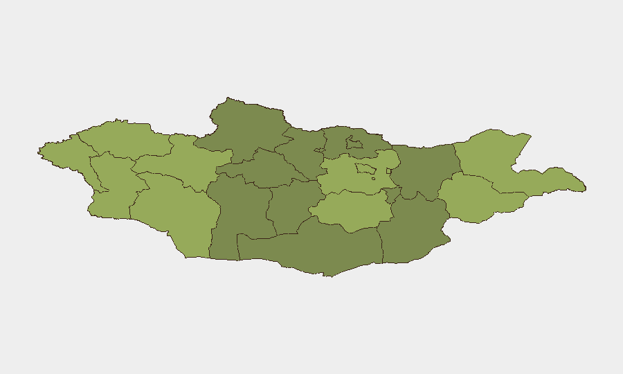
Situation Summary
Mongolia remains a low-threat environment globally (rank #172, composite score 3) with no verified security incidents, civil unrest, or conflict activity reported in the last 24–48 hours. The primary travel and operational risk continues to be nationwide fuel shortages affecting transport reliability and domestic/international flight schedules. Sub-national risk is concentrated in eastern and western border regions, likely reflecting cross-border activity, smuggling routes, and remote-area governance gaps rather than acute instability.
Key Developments
- No discrete security incidents reported in Mongolia for the 24–48 hour window (as of 2026-08-08). Standing travel advisories remain unchanged.
- Fuel supply constraints persist nationwide, affecting aircraft operations, petrol and diesel availability, and disruption to road transport and regional access. This is a logistics risk, not a security event, but impacts duty-of-care travel planning.
- Ulaanbaatar remains at moderate baseline risk with no new incident headlines or unrest signals in recent reporting (last confirmed advisory refresh: 2026-08-07).
- Border regions (Dornod, Sükhbaatar, eastern aimags) show elevated composite risk scores; drivers likely include remote terrain, limited state capacity, and cross-border trade/smuggling activity rather than active conflict.
Highest-Risk Areas
Dornod and Sükhbaatar aimags (northeastern Mongolia, bordering Russia) register the highest sub-national risk (58 and 55 respectively), followed by western frontier zones (Uvs, Khovd, Bayan-Ölgii). These rankings likely reflect remote geography, limited police/governance presence, cross-border smuggling networks, and informal economic activity rather than organized violence or insurgency. Ulaanbaatar (rank 45) remains moderate-risk, consistent with its role as the commercial and political hub but without current acute drivers. Western regions may also reflect seasonal herding disputes, water scarcity, or informal mining activity. No current indicators suggest imminent escalation in any ranked region.
How GeoBit Would Assist
Intel Sweep and multi-language OSINT fusion would provide real-time corroboration of fuel-supply disruptions and any emerging transport bottlenecks affecting asset mobility. AOI Monitoring & Early Warning on Dornod, Sükhbaatar, and western aimags would flag border-crossing disruptions, protest activity, or sudden police/military deployments. Routing & Network Analysis would enable alternative journey planning if fuel constraints tighten or road conditions degrade in specific regions, critical for duty-of-care compliance. Sentiment and temporal analysis on local media and Telegram channels would provide leading indicators of political friction or civil discontent before mainstream reporting.
7-Day Outlook
No material change to the current low-threat baseline is anticipated over the next 7 days. Fuel supply is likely to remain a logistical constraint through mid-August; teams should monitor Mongolian fuel ministry statements and carrier notices for flight cancellations. Border regions will continue to register elevated baseline risk, but without new trigger events or policy shifts, no acute risk escalation is forecast.
Highest-Risk Areas — Ranked
| # | State / Region | Risk |
|---|---|---|
| 1 | Dornod | 58 |
| 2 | Sükhbaatar | 55 |
| 3 | Uvs | 52 |
| 4 | Khovd | 50 |
| 5 | Bayan-Ölgii | 48 |
| 6 | Govi-Altai | 46 |
| 7 | Ulaanbaatar | 45 |
| 8 | Zavkhan | 44 |
| 9 | Töv | 42 |
| 10 | Dundgovi | 40 |
| 11 | Darkhan-Uul | 38 |
| 12 | Ömnögovi | 37 |
Sources
Previous Daily Briefs
A new Mongolia brief is written every day — each with its own risk map and downloadable CSV. Here's the last week; use the calendar to go further back.
📅 Browse every day by calendar →
Highlighted days have a brief. Tap a day for that day's map & analysis, or “csv” for that day's dataset ($5).
Atlas — our AI intelligence desk — emails them this snapshot personally. Nothing else, no list.