Situation Summary
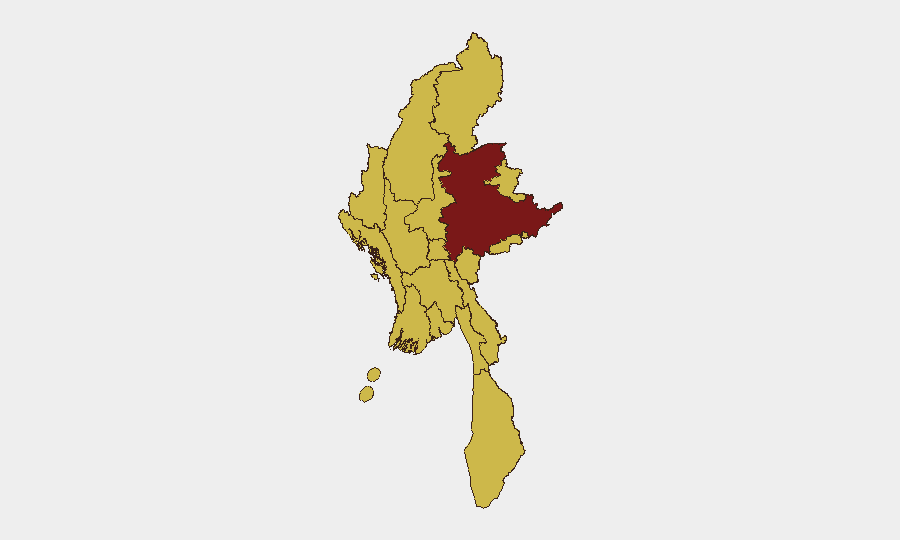
Myanmar remains in active civil conflict with a composite threat score of 100 (rank #9 globally), driven by ongoing armed opposition to the military junta across multiple regions. Diplomatic engagement with China (June 16 talks between Xi Jinping and Min Aung Hlaing) suggests effort to stabilize the conflict environment, but recent cross-border rhetoric and internal security statements indicate unresolved tensions. All-of-country risk persists at elevated levels, with Shan State presenting the single highest sub-national threat (risk 100).
Key Developments
- Beijing, China — June 16, 2026: Xi Jinping held formal talks with Myanmar's Min Aung Hlaing, with both sides signing cooperation documents covering transport, livelihood, and economic sectors. Xi publicly backed Myanmar's government and urged dialogue and reconciliation to secure stability in northern Myanmar—indicating Beijing's interest in preventing spillover conflict near Chinese borders.
- Myanmar–China Border Dynamics — June 17–18, 2026: Multiple public statements and threat exchanges between Myanmar authorities and China over unspecified border or governance matters (nine tracked diplomatic/rhetorical events recorded June 17–18), suggesting elevated cross-border tension despite the June 16 summit.
- Regional Diplomatic Responses — June 18, 2026: Indonesia and the United States issued public statements on Myanmar developments; Indonesian statement noted, and U.S. made multiple public positions on Myanmar governance and security issues—consistent with ongoing international pressure on the junta.
- Domestic Political Friction — June 18, 2026: Myanmar authorities disapproved of unspecified internal actions; separate public statements by Myanmar against its President suggest factional or governance tensions within the junta apparatus.
- Environmental Secondary Hazard — June 2026: Flood event recorded in Myanmar (Flood in Myanmar 1103937)—secondary threat to infrastructure, supply chains, and humanitarian access, particularly in already unstable regions.
Web Research Note: Incident-level security events (attacks, clashes, arrests) for June 18–19, 2026, could not be reliably confirmed from available open sources; the data corpus is dominated by diplomatic statements. A focused OSINT refresh for active conflict/unrest incidents is recommended.
Highest-Risk Areas
Shan State remains the single highest-risk sub-national zone (risk 100) and is the primary driver of Myanmar's overall threat score. A tier of nine regions—Tanintharyi, Chin, Sagaing, Kachin, Wa State (Northern Region), Magway, Mandalay, Rakhine, and Ayeyarwady—each score 70, with Yangon and Naypyitaw also at 70. This distribution indicates that civil-conflict risk is geographically pervasive: no major urban, administrative, or resource-rich region is isolated from armed opposition activity, supply-chain disruption, or junta counter-operations. Shan's elevated score reflects persistent armed-group presence, ethnic tensions, and proximity to the China border, where diplomatic strain compounds local instability.
How GeoBit Would Assist
Security teams should deploy AOI Monitoring & Early Warning to track Shan State and the nine tier-2 regions for conflict escalation, with real-time alerting on clashes or mass-casualty events. Intel Sweep and multi-language OSINT (X, Telegram, local Burmese sources) provide granular event confirmation and early signals of junta reprisal, supply-route closure, or cross-border spillover. Routing & Network Analysis enables duty-of-care teams to pre-plan alternative transport and evacuation routes around active conflict zones; Satellite & Imagery analysis confirms checkpoint positions and population displacement in real time.
7-Day Outlook
The June 16 China–Myanmar summit may temporarily reduce large-scale cross-border escalation, but the June 17–18 rhetorical exchanges and internal junta friction suggest fragile consensus. Armed opposition in Shan and adjoining regions is likely to maintain pressure on supply lines and forced-labor conscription; the flood event compounds humanitarian stress. No major tactical shift is expected within 7 days, but localized clashes and checkpoint tightening remain probable, particularly if junta internal divisions widen.
Highest-Risk Areas — Ranked
| # | State / Region | Risk |
|---|---|---|
| 1 | Shan State | 100 |
| 2 | Tanintharyi Region | 70 |
| 3 | Chin | 70 |
| 4 | Sagaing Region | 70 |
| 5 | Kachin State | 70 |
| 6 | Wa State (Northern Region) | 70 |
| 7 | Magway | 70 |
| 8 | Mandalay | 70 |
| 9 | Rakhine | 70 |
| 10 | Ayeyarwady | 70 |
| 11 | Yangon | 70 |
| 12 | Naypyitaw Union Territory | 70 |
Sources
Previous Daily Briefs
A new Myanmar brief is written every day — each with its own risk map and downloadable CSV. Here's the last week; use the calendar to go further back.
📅 Browse every day by calendar →
Highlighted days have a brief. Tap a day for that day's map & analysis, or “csv” for that day's dataset ($5).