Situation Summary
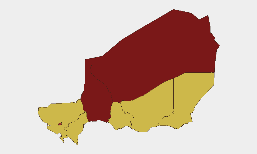
Niger remains the 13th highest-threat country globally (composite threat score 100) with 16 tracked events in the current monitoring window. The security environment is characterized by persistent instability in the Sahel-Sahara corridor, compounded by recent high-profile attacks on critical infrastructure in the capital. Threat vectors span armed group activity, civil unrest, and political tensions, with escalating risk concentrated in the northern and eastern regions. The trajectory suggests sustained volatility through the near term.
Key Developments
Limitation: Open-source corroboration for clearly dated, new security incidents in Niger within the last 24–48 hours (22–24 June 2026) is insufficient to confirm specific developments. The most recent verified incident in accessible reporting is the 18 June 2026 attack on Diori Hamani International Airport and adjacent military airbase in Niamey (11 security personnel and 2 civilians killed; 22 attackers killed, ~20 arrested), which falls outside the 24–48-hour window. Current event signals indicate ongoing political and civil friction (government rejections, public statements, threats, and producer demands documented 22–24 June), but precise locales and causal details remain unclear from available open sources. Cross-reference closed-source feeds, premium intelligence platforms, and real-time X/Twitter monitoring of Nigerien defence ministry, presidency, and interior-security accounts for time-stamped updates.
Highest-Risk Areas
Agadez and Tahoua regions dominate the risk landscape, scoring 99.6 and 98.4 respectively—driven by armed group presence, trafficking networks, and remote-area governance gaps. Niamey, despite lower sub-national ranking (78), carries elevated risk due to its status as the seat of government and demonstrated vulnerability to direct attack (airport strike, 18 June). Diffa, Tillabéri, and Zinder regions (all 69.6) face persistent cross-border spillover, militia activity, and community-level conflict. Northern and eastern regions remain the primary concern; Niamey requires heightened vigilance for security-force and critical-infrastructure targeting.
How GeoBit Would Assist
Intel Sweep and multi-language OSINT fusion would consolidate fragmented Nigerien government, security-service, and local media sources to confirm new incidents with precision dating and location. AOI Monitoring & Early Warning deployed on Agadez, Tahoua, Niamey, and Diffa would provide persistent, real-time alerts on armed-group movements, checkpoint activity, and civil unrest, enabling duty-of-care teams to anticipate staff exposure and route planning. Satellite & Imagery analysis combined with GIS & Spatial Analysis would map security-force deployments, damaged infrastructure, and corridor access around high-risk regions—critical for alternative-route planning and asset relocation decisions.
7-Day Outlook
Recent political tension signals and the June 18 airport attack suggest elevated near-term risk of secondary security-force actions, civil mobilization, or armed-group opportunism in northern regions and around Niamey. No imminent shift in threat trajectory is forecast; operations should assume persistent vigilance posture, contingency activation readiness, and real-time intelligence integration for the next 7 days. Monitor closed-source feeds and Nigerien official channels for government security-operation announcements or curfew/movement restrictions.
Highest-Risk Areas — Ranked
| # | State / Region | Risk |
|---|---|---|
| 1 | Agadez Region | 99.6 |
| 2 | Tahoua Region | 98.4 |
| 3 | Niamey | 78 |
| 4 | Zinder Region | 69.6 |
| 5 | Diffa Region | 69.6 |
| 6 | Tillabéri Region | 69.6 |
| 7 | Dosso Region | 69.6 |
| 8 | Maradi Region | 69.6 |
Previous Daily Briefs
A new Niger brief is written every day — each with its own risk map and downloadable CSV. Here's the last week; use the calendar to go further back.
📅 Browse every day by calendar →
Highlighted days have a brief. Tap a day for that day's map & analysis, or “csv” for that day's dataset ($5).