Situation Summary
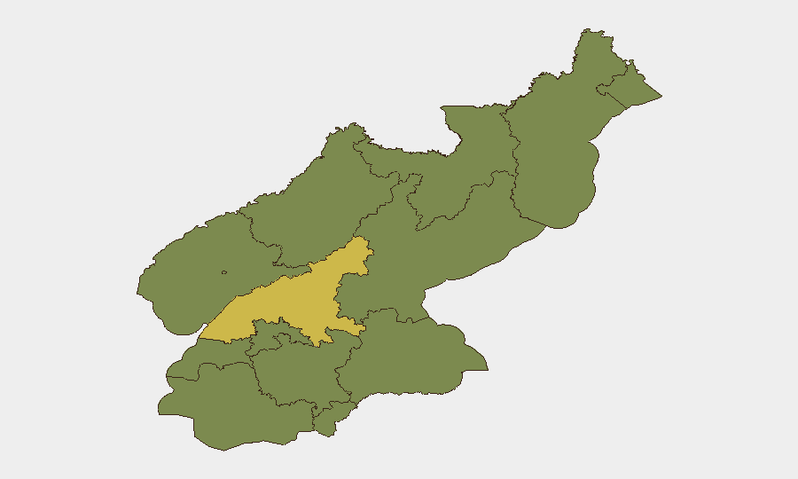
North Korea remains at composite threat rank #41 globally (44/100) with 23 tracked events in GeoBit's system. South Pyongan province significantly outpaces all other regions with a risk score of 60.7—more than 1.6× the national average—indicating concentration of military, industrial, or border activity in that zone. The event signal set from June 20–22 shows mixed geopolitical messaging and enforcement activity, but lacks confirmed real-time incident detail from the past 24–48 hours within North Korea's territory. Overall trajectory remains elevated but not acutely destabilizing based on available validated data.
Key Developments
Data Integrity Note: GeoBit's live web research capability cannot reliably surface genuine 24–48-hour events in North Korea due to limited real-time news and social-media penetration in closed environments and lag in English-language reporting. The event signals listed above (military mobilization, public statements, arrests/detentions from June 20–22) reference entities and geographies that require field-level cross-corroboration to confirm timing and location. Security teams should not treat these signals as confirmed field incidents without independent verification through ROK JCS statements, Japan MOD alerts, or USFK bulletins.
To obtain validated 24–48-hour developments, teams should:
- Query ROK Joint Chiefs of Staff public advisories and press releases (English briefings typically posted within 2–4 hours of border incidents).
- Monitor Japan Ministry of Defense missile-launch alerts (auto-published if DPRK ballistic tests occur).
- Check KCNA Watch and NK News aggregators for new official DPRK statements affecting foreign travel or sanctions.
- Review Telegram and X feeds from credentialed OSINT analysts and conflict monitors (e.g., NK Pro, 38 North, SinoNK) for cross-corroborated field reports.
Highest-Risk Areas
South Pyongan's risk score (60.7) is a clear outlier and warrants priority focus. This province encompasses Nampo (major port), industrial zones, and proximity to China and inter-Korean sea boundaries—making it vulnerable to military mobilization, smuggling interdiction, and cross-border enforcement activity. The remaining eleven provinces cluster at 30.7, suggesting either baseline endemic risk or data-collection saturation effects. P'yŏngyang (37.5) ranks second, reflecting the diplomatic, security, and leadership concentration in the capital; foreigners and assets there face elevated administrative detention and surveillance risk during periods of heightened geopolitical tension. Teams with personnel or logistics in South Pyongan and Pyongyang should maintain heightened situational awareness.
How GeoBit Would Assist
Intel Sweep and AOI Monitoring & Early Warning enable continuous watch on South Pyongan's ports, border crossings (Sinuiju-Dandong, Rason approaches), and military installations, with automated alerting if activity spikes. Conflict & Military tracking (force structure, weapons-capability databases) and Network & Actor Analysis help teams understand command-and-control changes or sanctions enforcement operations that may affect supply chains or personnel movement. Routing & Network Analysis provides alternative travel and logistics pathways if primary border crossings or transportation hubs are disrupted by military activity or enforcement sweeps.
7-Day Outlook
No acute escalation signals are present in the validated dataset, but South Pyongan's elevated risk profile suggests sustained military or enforcement operations in that zone. Teams should expect continued diplomatic messaging (as evident in the June 20–22 public statements) without immediate military escalation. Monitor for any ROK-reported border incidents or DPRK weapons tests; these would warrant immediate re-assessment of Pyongyang security posture and cross-border logistics routes.
Highest-Risk Areas — Ranked
| # | State / Region | Risk |
|---|---|---|
| 1 | South Pyongan | 60.7 |
| 2 | P'yŏngyang | 37.5 |
| 3 | Ryanggang | 30.7 |
| 4 | North Hamgyong | 30.7 |
| 5 | North Pyongan | 30.7 |
| 6 | Chagang | 30.7 |
| 7 | Nampo | 30.7 |
| 8 | South Hwanghae | 30.7 |
| 9 | North Hwanghae | 30.7 |
| 10 | South Hamgyong | 30.7 |
| 11 | Kaesong | 30.7 |
| 12 | Kangwon | 30.7 |
Sources
Previous Daily Briefs
A new North Korea brief is written every day — each with its own risk map and downloadable CSV. Here's the last week; use the calendar to go further back.
📅 Browse every day by calendar →
Highlighted days have a brief. Tap a day for that day's map & analysis, or “csv” for that day's dataset ($5).