Situation Summary
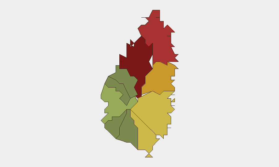
Saint Lucia remains a jurisdiction of moderate underlying risk, with a composite threat score of 2 and no tracked discrete security events in the current monitoring window. The island's security profile is concentrated in urban and transit corridors, particularly Castries, where organized crime, narcotics trafficking, and inter-gang violence constitute the primary drivers of risk. The wider archipelago experiences lower incident density outside the capital and northern coast, though prison security, weapons trafficking, and port-control challenges persist as institutional vulnerabilities.
Key Developments
No discrete security events have been verified within the last 24–48 hours. The most recent credible incident reporting available in public sources dates to July 2026 or earlier, and does not meet the current-window threshold for inclusion as an active development. Web research across local media and archived law-enforcement announcements has not yielded timestamped incidents occurring after 2026-08-01 at 00:00 UTC.
Background context (not current developments): Since at least July 2026, Saint Lucia police have conducted firearms and ammunition seizure operations across multiple districts (Castries, Bexon, Dennery, Jacmel, Gros Islet), and prison security officials have expanded restricted-access zones at Bordelais Correctional Facility in response to internal-order concerns. Port-authority and narcotics units have also maintained active investigations into smuggling networks at Port Castries, though no specific interdictions have been corroborated within the last 48 hours.
Highest-Risk Areas
Castries (risk 95) and Gros Islet (risk 78) account for the majority of Saint Lucia's composite threat score, driven by gang-affiliated violence, informal-economy conflict, and port-adjacent trafficking activity. Castries, as the capital and primary commercial hub, concentrates police presence and criminal-incident density; Gros Islet's high ranking reflects its role as a secondary urban and tourist corridor susceptible to organized-crime turf competition. Dennery (72), Vieux Fort (68), and Micoud (65) represent secondary-tier risk zones where gang presence and narcotics transshipment are documented but less acute than in the capital. Southern and western districts (Soufrière, Laborie, Choiseul, Anse La Raye, Canaries) remain significantly lower-risk, reflecting lower population density and reduced organized-crime infrastructure.
How GeoBit Would Assist
Corporate security and duty-of-care teams would employ AOI Monitoring & Early Warning (persistent geographic watch on Castries, Gros Islet, and port facilities with alerting on incident spikes), Intel Sweep and multi-language OSINT fusion (daily corroboration of local media, police announcements, and social-media signals to fill the current 24–48-hour reporting gap), and Network & Actor Analysis (mapping of gang structures and trafficking networks to anticipate displacement or escalation in high-risk districts). Routing & Network Analysis would support alternative journey planning for personnel transiting between asset locations and away from highest-risk corridors during periods of elevated gang activity.
7-Day Outlook
No specific security incidents are forecast for the near term, but seasonal patterns and the island's underlying vulnerability to narcotics-trafficking disruptions warrant sustained baseline monitoring. Staff and asset movements in Castries and Gros Islet should continue to operate under standard urban-crime protocols, with particular attention to port zones and informal-settlement interfaces where incident reporting is historically sparse.
Highest-Risk Areas — Ranked
| # | State / Region | Risk |
|---|---|---|
| 1 | Castries | 95 |
| 2 | Gros Islet | 78 |
| 3 | Dennery | 72 |
| 4 | Vieux Fort | 68 |
| 5 | Micoud | 65 |
| 6 | Soufrière | 42 |
| 7 | Laborie | 38 |
| 8 | Choiseul | 35 |
| 9 | Anse La Raye | 28 |
| 10 | Canaries | 12 |
Sources
- unitedpacstlucia.com
- unitedpacstlucia.com
- saintluciadailypost.com
- stluciatimes.com
- saintluciadailypost.com
- youtube.com
- unitedpacstlucia.com
- thevoiceslu.com
- thestkittsnevisobserver.com
- saintluciadailypost.com
- saintluciadailypost.com
- unitedpacstlucia.com
- thestkittsnevisobserver.com
- stluciatimes.com
- thestkittsnevisobserver.com
- thestkittsnevisobserver.com
- thevoiceslu.com
- stluciatimes.com
Previous Daily Briefs
A new Saint Lucia brief is written every day — each with its own risk map and downloadable CSV. Here's the last week; use the calendar to go further back.
📅 Browse every day by calendar →
Highlighted days have a brief. Tap a day for that day's map & analysis, or “csv” for that day's dataset ($5).
Atlas — our AI intelligence desk — emails them this snapshot personally. Nothing else, no list.