Situation Summary
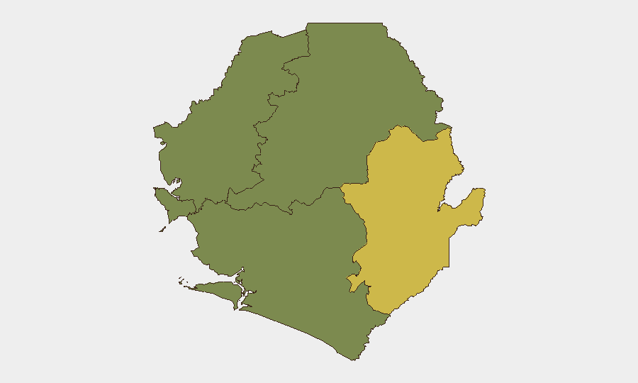
Sierra Leone remains in a low-to-moderate threat environment with a composite threat score of 12 (global rank #88). No verified security incidents, civil unrest, infrastructure disruption, or acute travel risks have been confirmed in the last 24–48 hours from corroborated open-source channels. The country's risk profile is heavily concentrated in the Eastern Province; the Western Area (Freetown and immediate surroundings) carries secondary risk. Barring emergence of new triggering events, the near-term security posture is expected to remain stable.
Key Developments
No discrete security, conflict, crime, or civil-unrest incidents meeting verification criteria (timestamp within 2026-07-03 to 2026-07-05, corroborated across multiple OSINT/social feeds) have been identified for Sierra Leone in the last 24–48 hours.
Note on event signals: GeoBit's platform flagged two public statements by a chief executive on 2026-07-03 (one directed at Africa generally, one at Nigeria specifically); these do not appear to constitute incidents within Sierra Leone's borders and do not carry confirmed operational impact on security, travel, or personnel safety within the reporting period.
Regional monitoring of neighboring Liberia and broader West African feeds shows no cascading incidents or border-related developments that would indicate indirect threat escalation into Sierra Leone during this period.
Highest-Risk Areas
Eastern Province dominates the sub-national risk profile (composite risk score 68) and should remain the primary geographic focus for duty-of-care and asset-protection planning. Western Area (Freetown, port, airport, principal commercial hub) carries moderate secondary risk (score 35), reflecting concentration of population, critical infrastructure, and international presence. Northern Province, North West Province, and Southern Province show zero or minimal tracked risk and are assessed as lower-priority zones for current active monitoring. Organizations with personnel or operations in the Eastern Province should maintain elevated situational awareness and consider whether contingency protocols (evacuation, safe-haven access, communication redundancy) remain current and regularly exercised.
How GeoBit Would Assist
Teams managing Sierra Leone exposure should employ AOI Monitoring & Early Warning with persistent watches on Eastern Province and Freetown to detect emerging civil unrest, security incidents, or infrastructure disruption in near-real time. Intel Sweep and multi-language OSINT fusion (X/Twitter, Telegram, YouTube, regional news) provide corroborated, time-stamped incident detection across borders, enabling rapid escalation to operations and security leadership. Routing & Network Analysis can support safe-haven and evacuation planning by identifying alternative transit corridors and checkpoints in the event of localized instability.
7-Day Outlook
No acute threat catalysts are apparent on the near-term horizon (next 7 days). Barring unforeseen political or security triggers, Sierra Leone is expected to remain in its current low-incident baseline. Continued monitoring of Eastern Province and Western Area through persistent OSINT collection is standard prudent practice; no emergency-level escalation in operations posture is warranted at this time.
Highest-Risk Areas — Ranked
| # | State / Region | Risk |
|---|---|---|
| 1 | Eastern Province | 68 |
| 2 | Western Area | 35 |
| 3 | North West Province, Sierra Leone | 0 |
| 4 | Northern Province, Sierra Leone | 0 |
| 5 | Southern Province, Sierra Leone | 0 |
Sources
Previous Daily Briefs
A new Sierra Leone brief is written every day — each with its own risk map and downloadable CSV. Here's the last week; use the calendar to go further back.
📅 Browse every day by calendar →
Highlighted days have a brief. Tap a day for that day's map & analysis, or “csv” for that day's dataset ($5).
Atlas — our AI intelligence desk — emails them this snapshot personally. Nothing else, no list.