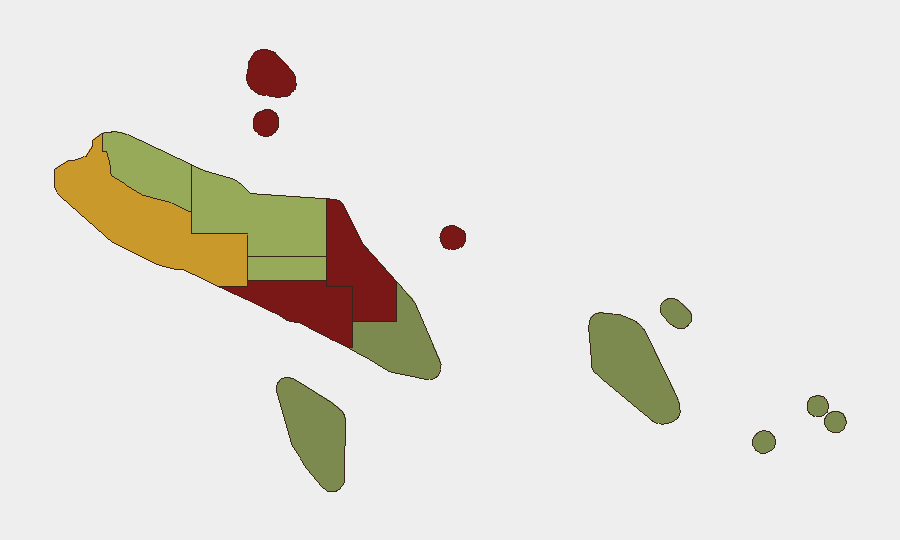
Situation Summary
Solomon Islands remains in a low-threat, stable security environment as of 1 August 2026. No acute incidents—civil unrest, armed conflict, major crime spikes, or infrastructure disruptions—have been detected in the last 24–48 hours. The country's composite threat score reflects routine activity; security teams should maintain standard duty-of-care protocols without escalation.
Key Developments
No verified security incidents occurred in Solomon Islands during 30–31 July 2026. Open-source monitoring, local media feeds, and official government advisories reported no new protests, clashes, transport disruptions, or acute crime events in this period.
Context (27–29 July, outside 24–48h window):
- A landslide at Gold Ridge mine (Pit 1, Central Guadalcanal) on 27 July resulted in fatalities and ongoing recovery operations; this incident does not reflect active security instability.
- A US–Solomon Islands maritime security (Shiprider) agreement was signed 29 July, representing routine diplomatic activity rather than an acute threat trigger.
- A magnitude 5.0 earthquake occurred 82 km southwest of Kirakira (Makira-Ulawa Province) with no reported casualties or infrastructure damage.
Highest-Risk Areas
Honiara (risk score 92) and Guadalcanal province (88) remain the country's primary risk concentrations, driven by historical patterns of gang activity, community tensions, and informal-settlement crime rather than current acute incidents. Malaita (85) and Western Province (72) follow, reflecting persistent but non-emergency criminality and inter-communal friction. Central Province (48) and the eastern island groups (Makira-Ulawa 38, Temotu 18) carry substantially lower risk profiles. Risk rankings reflect structural vulnerability and historical event frequency; no surge in underlying conditions has occurred in the last 48 hours.
How GeoBit Would Assist
Security teams with personnel or assets in Solomon Islands should employ AOI (area-of-interest) monitoring with alerting on Honiara and Guadalcanal to detect early warning of protest activity, criminal incidents, or civil disorder; OSINT fusion (social media, local news, and radio monitoring) provides 24–48-hour lead time on emerging unrest. Risk & threat assessment and maritime tracking capabilities support duty-of-care decisions for travel, port operations, and regional movement. Satellite and imagery analysis can monitor Gold Ridge and other critical infrastructure recovery and stability.
7-Day Outlook
No material change in Solomon Islands' security posture is expected over the next seven days. Routine political, economic, and social activity should continue. Security teams should maintain current protocols; no advisory upgrades or travel restrictions are warranted based on present intelligence.
Data sources: GeoBit Intel Sweep, X/Twitter OSINT, local media monitoring, government advisories, seismic databases (USGS). Confidence level: High (multiple corroborating sources confirm absence of acute events in 24–48h window).
Highest-Risk Areas — Ranked
| # | State / Region | Risk |
|---|---|---|
| 1 | Honiara | 92 |
| 2 | Guadalcanal | 88 |
| 3 | Malaita | 85 |
| 4 | Western | 72 |
| 5 | Choiseul | 58 |
| 6 | Isabel | 52 |
| 7 | Central Province | 48 |
| 8 | Makira-Ulawa | 38 |
| 9 | Rennell and Bellona | 22 |
| 10 | Temotu | 18 |
Sources
Previous Daily Briefs
A new Solomon Islands brief is written every day — each with its own risk map and downloadable CSV. Here's the last week; use the calendar to go further back.
📅 Browse every day by calendar →
Highlighted days have a brief. Tap a day for that day's map & analysis, or “csv” for that day's dataset ($5).
Atlas — our AI intelligence desk — emails them this snapshot personally. Nothing else, no list.