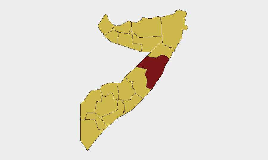
Situation Summary
Somalia remains at elevated threat level (#11 globally, composite score 94) driven primarily by Al‑Shabaab insurgency activity across multiple regions. The past 48 hours have seen coordinated militant attacks on military installations in the central and southwestern regions, alongside sustained IED and intimidation operations near the capital. Puntland continues to face governance and press-freedom pressures, while maritime hostage situations persist in the Gulf of Aden. The security picture reflects active, dispersed militant presence rather than territorial collapse, but operational tempo and geographic spread warrant continued vigilance.
Key Developments
- Wajid Airport, Bakool region – 11 July 2026: Al‑Shabaab mounted a coordinated assault on Ethiopian troops at Wajid Airport during a military resupply operation, resulting in sustained firefighting; casualty and damage assessments remain pending.
- Garbaharey, Gedo region – 11 July 2026: Hours after Wajid, Al‑Shabaab launched a second attack on the Somali government's "WFP camp" military base, triggering pre-dawn combat; no verified casualty figures released.
- Ma'aane & Elasha Biyaha, west of Mogadishu – through 10 July 2026: Armed Al‑Shabaab patrols conducted door-to-door civilian questioning and intimidation operations in suburbs 10–15 km west of Mogadishu, indicating persistent militant presence in the capital's western approaches.
- Ma'aane, west of Mogadishu – days before 10 July 2026: A roadside IED detonated against security forces, part of a continuing sequence of explosions targeting government convoys on western approaches to Mogadishu.
- Gulf of Aden / Red Sea – reported 6 July 2026, ongoing: International Maritime Organization reports 44 seafarers held hostage across three vessels following April–May pirate attacks, with 24 attempted or successful piracy incidents in the preceding three months.
- Garowe, Puntland – 9 July 2026: Journalists staged a protest demanding the release of reporter Suways Jama Mahmoud, detained since 2 July without court appearance, reflecting press-freedom and arbitrary detention concerns in Puntland.
Highest-Risk Areas
Mudug (95.9) stands significantly above all other regions, driven by active insurgent operations and military engagement. The tier-two cluster—Awdal, Woqooyi Galbeed, Gedo, Bakool, Bay, Middle Juba, Lower Shabelle, Sahil, Togdheer, Hiiraan, and Middle Shebelle (all 65.9)—reflects widespread Al‑Shabaab presence and operational capacity across southern and central Somalia. Bakool and Gedo, sites of the 11 July attacks, are particularly active; western approaches to Mogadishu (Lower Shabelle/Middle Shebelle interface) sustain elevated IED and intimidation risk. The sub-national distribution indicates a decentralized but coordinated threat rather than concentration in a single enclave.
How GeoBit Would Assist
Corporate security and duty-of-care teams should employ AOI Monitoring & Early Warning on Mudug, Bakool, Gedo, and western Mogadishu corridors to detect tactical shifts and cumulative threat escalation. Conflict & Military battle mapping and force-structure analysis would clarify Ethiopian and Somali government response postures and Al‑Shabaab capability trends. Maritime & Aviation tracking combined with entity and network analysis would support supply-chain and personnel-movement risk assessment in high-threat regions and offshore hostage-situation monitoring.
7-Day Outlook
Al‑Shabaab maintains operational initiative across multiple regions with apparent coordination capability. Military bases and supply operations remain priority targets; IED activity and civilian intimidation will likely persist near Mogadishu. No immediate de-escalation indicators are visible; heightened vigilance for secondary attacks and roadside threats is warranted across central and southwestern zones.
Highest-Risk Areas — Ranked
| # | State / Region | Risk |
|---|---|---|
| 1 | Mudug | 95.9 |
| 2 | Awdal | 65.9 |
| 3 | Woqooyi Galbeed | 65.9 |
| 4 | Gedo | 65.9 |
| 5 | Bakool | 65.9 |
| 6 | Bay | 65.9 |
| 7 | Middle Juba | 65.9 |
| 8 | Lower Shabelle | 65.9 |
| 9 | Sahil | 65.9 |
| 10 | Togdheer | 65.9 |
| 11 | Hiiraan | 65.9 |
| 12 | Middle Shebelle | 65.9 |
Sources
Previous Daily Briefs
A new Somalia brief is written every day — each with its own risk map and downloadable CSV. Here's the last week; use the calendar to go further back.
📅 Browse every day by calendar →
Highlighted days have a brief. Tap a day for that day's map & analysis, or “csv” for that day's dataset ($5).
Atlas — our AI intelligence desk — emails them this snapshot personally. Nothing else, no list.