Situation Summary
South Sudan remains in a volatile equilibrium following Independence Day commemorations (9 July), with coordinated attacks on government facilities in Warrap State killing at least 15 people and triggering a security crackdown across key population centers. Concurrent clashes between SSPDF and SPLA‑IO factions in Jonglei State—intensified by the assassination of Akobo County Commissioner James Kueth Makuach on 5 July—have destabilized civilian movement and oil-sector access in the northeast. Intra-elite political friction, visible during recent Juba ceremonies, compounds the risk of uncontrolled security responses and localized violence around administrative nodes.
Key Developments
- Akobo West County, Jonglei State (13–14 July): Fresh clashes between SSPDF and SPLA‑IO reported near Walgak; road ambush risks confirmed for humanitarian and commercial traffic following Commissioner Makuach's targeted killing on 5 July; civilian casualties ongoing.
- Warrap State (night of 8–9 July, follow-up through 14 July): Coordinated attacks on government facilities during Independence observances killed ≥15 and wounded 12; security forces deployed with checkpoints and intensified screening continuing through mid-July; authorities warn of potential follow-on clashes.
- Juba and major highway corridors (13–14 July): SSPDF and police presence increased with ad-hoc roadblocks and aggressive vehicle screening on Juba–Bor and Juba–Yei routes in response to recent unrest; travel disruption and checkpoint confrontation risk elevated.
- Juba, Central Equatoria (12 July): Public political confrontation between Napwon and Jubek Deputy Governor during Jubek Day celebrations triggered security alert and visible elite tension, signaling risk of politically triggered disorder around state events.
- Unity and Central Equatoria States (13–14 July): Country risk reporting identifies volatile civil-unrest and armed-activity pockets; localized clashes and criminality intensified in early–mid July, affecting aid-worker mobility.
Highest-Risk Areas
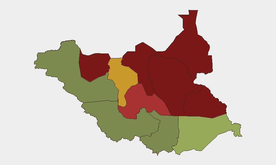
Unity, Jonglei, and Upper Nile States dominate the threat landscape, with composite risk scores of 95, 93, and 88 respectively. Jonglei's ranking reflects active SSPDF–SPLA‑IO confrontation, targeted killings of officials, and ambush activity along major transport corridors; Unity State faces generalized armed activity and criminality. Northern Bahr el Ghazal and Greater Pibor Administrative Area remain severe-risk zones with persistent inter-communal and factional violence. By contrast, Central Equatoria (risk 35) and Western Bahr el Ghazal (risk 28)—though hosting the capital and containing oil infrastructure—show lower composite scores, though Juba itself remains a locus of elite political friction and checkpoint intensity.
How GeoBit Would Assist
Security teams should employ AOI Monitoring & Early Warning to track Jonglei, Warrap, and Unity states for armed-activity signals, checkpoint activity, and ambush indicators; Intel Sweep and multi-language OSINT to monitor local and regional outlets, Telegram, and radio for militia statements and casualty reports; and Routing & Network Analysis to generate dynamic alternative-route options for staff and supply movements, accounting for real-time blockades and confrontation zones. Conflict & Military battle mapping would clarify factional positions around Akobo West and Warrap to inform movement planning.
7-Day Outlook
Warrap State security operations will likely continue intensive checkpoints and deployments through mid-to-late July as authorities respond to the coordinated attacks. Jonglei clashes are expected to persist in border zones near Akobo West absent credible mediation; road access risk will remain elevated. Political tensions in Juba may intensify around remaining Independence-related ceremonies, raising the likelihood of localized confrontations at security checkpoints and administrative sites.
Highest-Risk Areas — Ranked
| # | State / Region | Risk |
|---|---|---|
| 1 | Unity | 95 |
| 2 | Jonglei | 93 |
| 3 | Upper Nile | 88 |
| 4 | Greater Pibor Administrative Area | 87 |
| 5 | Northern Bahr el Ghazal | 82 |
| 6 | Lakes | 78 |
| 7 | Warrap | 72 |
| 8 | Ruweng Administrative Area | 68 |
| 9 | Eastern Equatoria | 52 |
| 10 | Western Equatoria | 38 |
| 11 | Central Equatoria | 35 |
| 12 | Western Bahr el Ghazal State | 28 |
Sources
Previous Daily Briefs
A new South Sudan brief is written every day — each with its own risk map and downloadable CSV. Here's the last week; use the calendar to go further back.
📅 Browse every day by calendar →
Highlighted days have a brief. Tap a day for that day's map & analysis, or “csv” for that day's dataset ($5).
Atlas — our AI intelligence desk — emails them this snapshot personally. Nothing else, no list.