Situation Summary
Suriname remains at baseline risk with no verified security incidents in the past 24–48 hours. The national threat environment is stable, with no acute escalation anticipated in the immediate term. However, sub-national disparities are pronounced: interior districts (Sipaliwini, Brokopondo, Para) carry structural risk tied to criminal activity and armed group presence, while coastal urban zones (Paramaribo, Marowijne) maintain elevated but contained risk profiles. Overall security posture for corporate personnel and assets is manageable under standard duty-of-care protocols.
Key Developments
- No verified security incidents reported countrywide in the last 24–48 hours. Open-source monitoring (news outlets, embassy advisories, social media) has surfaced no credible reports of civil unrest, armed clashes, major crime spikes, or infrastructure failures in this window.
- Paramaribo & coastal districts remain at elevated baseline risk with no new incident activity. Urban security conditions are stable relative to historical norms; no reports of localized crime escalation or unrest in the past 48 hours.
- Interior regions (Sipaliwini, Brokopondo, Para) continue structural exposure to criminal and armed-group activity, with no new location-specific events verified in the last 24–48 hours. Risk in these zones is persistent but not acutely triggered at present.
- 7-day outlook signals no anticipated escalation. Analysts assess the operating environment will remain at current baseline levels, with no near-term incident triggers identified.
Highest-Risk Areas
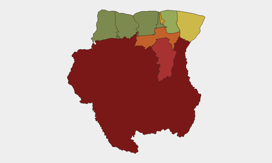
Sipaliwini (risk score 92), Brokopondo (78), and Para (74) dominate the sub-national ranking and reflect the interior's structural vulnerability to illegal mining, narcotics trafficking, and armed-group presence. These sparsely populated, border-proximate districts lack consistent state authority and law-enforcement capacity. Paramaribo (71) and Marowijne (68), while coastal and more developed, carry elevated urban and border-crossing risk respectively—organized crime, gang activity, and transnational smuggling networks operate in both. Commewijne and Wanica present moderate risk tied to peri-urban criminal activity. Coronie and Nickerie rank lowest and are suitable for standard corporate operations with routine precautions.
How GeoBit Would Assist
Teams managing Suriname exposure should deploy Intel Sweep and multi-language OSINT across regional news, social media, and institutional alerts to detect early signals of crime, civil unrest, or armed-group activity before escalation. AOI Monitoring & Early Warning on Sipaliwini, Brokopondo, and Paramaribo would provide persistent, geo-targeted alerts tied to incident thresholds, enabling proactive duty-of-care response. GIS & Spatial Analysis and Routing & Network Analysis support alternative-route planning for personnel and supply chains, bypassing high-risk interior and border zones during elevated periods.
7-Day Outlook
No acute escalation is anticipated over the next seven days. The security environment is expected to remain at baseline, with interior-region risk persisting at structural rather than acute levels. Corporate teams should maintain routine monitoring and standard travel protocols while remaining positioned to scale response if incident triggers emerge in high-risk zones.
Highest-Risk Areas — Ranked
| # | State / Region | Risk |
|---|---|---|
| 1 | Sipaliwini | 92 |
| 2 | Brokopondo | 78 |
| 3 | Para | 74 |
| 4 | Paramaribo | 71 |
| 5 | Marowijne | 68 |
| 6 | Commewijne | 42 |
| 7 | Wanica | 38 |
| 8 | Saramacca | 29 |
| 9 | Coronie | 12 |
| 10 | Nickerie | 8 |
Sources
Previous Daily Briefs
A new Suriname brief is written every day — each with its own risk map and downloadable CSV. Here's the last week; use the calendar to go further back.
📅 Browse every day by calendar →
Highlighted days have a brief. Tap a day for that day's map & analysis, or “csv” for that day's dataset ($5).
Atlas — our AI intelligence desk — emails them this snapshot personally. Nothing else, no list.