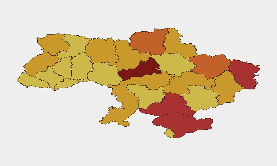
Situation Summary
Ukraine remains under sustained Russian offensive pressure, with aerial bombardment of Kyiv and central regions intensifying over the past 48 hours and Ukrainian air operations expanding into Russian territory. The composite threat score of 100 reflects active large-scale warfare, elevated civilian casualty risk in capital and regional centers, and critical infrastructure under repeated attack. Current trajectory shows no de-escalation; both sides are executing multi-domain strikes, and air defense requirements continue to outpace Ukrainian supply.
Key Developments
- Kyiv, central districts – July 1–2, 2026 (overnight): Russian missile and drone strikes detonated in central Kyiv, triggering fires and injuring at least five civilians. Air raid alerts preceded the attacks; emergency services deployed under continued threat. President Zelensky reiterated urgent calls for additional air defense systems.
- Kyiv, multiple neighborhoods – July 2 early morning: Follow-on Russian drone and missile strikes hit multiple Kyiv districts, with fires reported and additional civilian injuries confirmed by Ukrainian authorities.
- Poltava region – July 1, 2026: A Ukrainian twin-engine fighter jet crashed during a combat mission and was likely shot down by a Russian long-range air-to-air missile, reflecting sustained high-risk air operations across central Ukraine.
- Crimea (Russian-occupied) – July 1, 2026: Ukrainian drone and missile strikes targeted Russian energy infrastructure and logistics nodes in occupied Crimea, exacerbating ongoing blackouts and fuel shortages for Russian occupation authorities.
- Cross-border Ukraine-to-Russia drone campaign – June 30–July 1, 2026: Ukraine executed a large-scale drone offensive into Russian territory, targeting refineries and critical infrastructure across multiple regions and the Moscow periphery; Russian officials reported fuel shortages and rationing as a result.
Highest-Risk Areas
Kyiv and Cherkasy Oblast dominate the risk ranking due to direct exposure to Russian aerial bombardment and proximity to active combat zones. Kyiv's rank-100 score reflects its status as Ukraine's administrative and economic center and its persistent vulnerability to missile and drone strikes despite air defense deployments. Cherkasy Oblast (90.3) lies in central Ukraine and serves as a logistics corridor; it faces spillover from Russian operations targeting broader central Ukrainian infrastructure. Crimea, Kherson, Luhansk, and Kharkiv oblasts all exceed risk 75, driven by direct ground contact, occupation, or proximity to active frontlines. Organizations with personnel or critical assets in Kyiv and central oblasts face the highest duty-of-care and operational continuity risk.
How GeoBit Would Assist
Security and risk teams would deploy AOI Monitoring & Early Warning on Kyiv and other high-risk oblasts to receive real-time alerts on air raid activity, drone/missile strikes, and route disruption. Conflict & Military capabilities—including battle mapping and weapons-capability tracking—would track Russian strike patterns, Ukrainian air defense effectiveness, and force disposition changes. Intel Sweep and OSINT fusion (X/Telegram/YouTube sources, sentiment analysis, multi-language feeds) would provide corroborated situational updates faster than traditional reporting, enabling faster duty-of-care decisions and evacuation or shelter protocols.
7-Day Outlook
Russian aerial operations against Kyiv and central Ukraine are expected to continue at current or elevated intensity. Ukrainian cross-border strikes into Russian territory will likely persist, creating secondary risk through potential Russian retaliation escalation or miscalculation. Civilian casualty risk and critical infrastructure degradation remain the primary near-term threat vectors for personnel and assets in risk-ranked regions.
Highest-Risk Areas — Ranked
| # | State / Region | Risk |
|---|---|---|
| 1 | Kyiv | 100 |
| 2 | Cherkasy Oblast | 90.3 |
| 3 | Autonomous Republic of Crimea | 79 |
| 4 | Kherson Oblast | 78.8 |
| 5 | Luhansk Oblast | 78.5 |
| 6 | Kharkiv Oblast | 75.7 |
| 7 | Chernihiv Oblast | 73 |
| 8 | Odesa Oblast | 72.7 |
| 9 | Dnipropetrovsk Oblast | 72.6 |
| 10 | Donetsk Oblast | 72.6 |
| 11 | Kirovohrad Oblast | 72.3 |
| 12 | Sumy Oblast | 72 |
Sources
Previous Daily Briefs
A new Ukraine brief is written every day — each with its own risk map and downloadable CSV. Here's the last week; use the calendar to go further back.
📅 Browse every day by calendar →
Highlighted days have a brief. Tap a day for that day's map & analysis, or “csv” for that day's dataset ($5).