Situation Summary
Venezuela faces a critical humanitarian and security inflection following two major earthquakes on 24 June 2026, with a nationwide death toll exceeding 1,400 and tens of thousands reported missing. Search-and-rescue operations remain active in Caracas and affected provinces under a declared state of emergency, with military deployments and movement controls in effect. The earthquake-driven displacement, infrastructure collapse, and resource scarcity are elevating secondary instability risks—looting, civil disorder, and overwhelmed local authority response—superimposed on Venezuela's existing chronic crime and political volatility.
Key Developments
- Caracas, 1–2 July 2026: U.S. urban search-and-rescue teams from California and Virginia are conducting active survivor extraction from collapsed residential structures; one documented rescue included a mother and nine-month-old infant recovered from rubble within 24 hours of the initial quake. Operations are concentrated in neighborhoods with the heaviest structural damage.
- Nationwide, 1–2 July 2026: International humanitarian organizations (World Central Kitchen, World Food Programme, Mexican "Topos" rescue teams, and specialized K-9 units) have established logistics hubs and meal distribution points in Caracas and other affected urban centers, signaling sustained foreign operational presence and staging activity.
- Nationwide, 30 June–2 July 2026: Casualty and missing-persons figures have been updated by aid agencies, confirming death toll exceeding 1,400 with tens of thousands unaccounted for; these figures are driving significant displacement and resource-scarcity pressures in urban zones.
- Caracas and urban centers, 1–2 July 2026: Extensive residential and critical infrastructure damage (collapsed buildings, blocked roads, damaged utilities) is complicating emergency-service access and creating secondary risks including crime opportunities (looting) in damaged areas; specific criminal incidents are not yet systematically documented in open sources.
- UK FCDO update, 30 June–2 July 2026: Venezuela travel advice was updated to advise against all travel, citing crime, civil unrest, poor health infrastructure, and arbitrary arrest, with explicit reference to earthquake-related disruption. This signals elevated duty-of-care concern for foreign nationals across all regions.
- Nationwide, late June–early July 2026: State of emergency and military deployments remain in effect, with reports of strikes and stability operations across provinces including Caracas; curfews and movement controls are expected to persist and constrain normal business and staff mobility.
Highest-Risk Areas
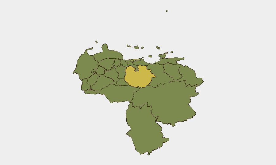
Guarico State (63.3) and the Federal District/Caracas (56.9) are the highest-scored regions, reflecting both pre-earthquake instability drivers and acute earthquake impacts. Vargas State (43.8) and Carabobo State (39.7) follow, suggesting significant geographic dispersion of secondary risks beyond the capital. The earthquake has amplified vulnerability in all urban centers where infrastructure damage, displacement, and overwhelmed authorities create conditions favoring looting, supply-chain disruption, and civil order degradation.
How GeoBit Would Assist
Security teams should deploy AOI Monitoring & Early Warning to track Caracas, Guarico, Vargas, and Carabobo for signs of escalating civil unrest, looting, or checkpoint activity. Intel Sweep and multi-language OSINT (X/Twitter, Telegram, local news feeds) provide real-time event corroboration and sentiment analysis to distinguish earthquake-related disruption from emerging political or criminal flashpoints. Routing & Network Analysis supports alternative journey planning and safe-passage assessment as curfews and military checkpoints evolve across affected provinces.
7-Day Outlook
Rescue operations are expected to taper as the critical 72-hour window closes, shifting focus to recovery and displacement management. Military presence and curfews will likely remain in place through early–mid July, constraining staff mobility and supply logistics. Secondary instability (looting, resource conflicts, civil order degradation) poses the near-term risk; political opportunism and potential regime-stability complications may emerge as casualty counts and failures in emergency response become subjects of public criticism.
Highest-Risk Areas — Ranked
| # | State / Region | Risk |
|---|---|---|
| 1 | Guarico State | 63.3 |
| 2 | Federal District | 56.9 |
| 3 | Vargas State | 43.8 |
| 4 | Carabobo State | 39.7 |
| 5 | Anzoategui State | 38.1 |
| 6 | Miranda State | 33.8 |
| 7 | Zulia State | 33.7 |
| 8 | Barinas State | 33.7 |
| 9 | Aragua State | 33.5 |
| 10 | Falcon State | 33.3 |
| 11 | Federal Dependencies | 33.3 |
| 12 | Nueva Esparta State | 33.3 |
Sources
Previous Daily Briefs
A new Venezuela brief is written every day — each with its own risk map and downloadable CSV. Here's the last week; use the calendar to go further back.
📅 Browse every day by calendar →
Highlighted days have a brief. Tap a day for that day's map & analysis, or “csv” for that day's dataset ($5).