Situation Summary
Eritrea remains a low-frequency event environment with no confirmed security incidents reported in the last 24–48 hours. Structural risks—including border tensions, regional military activity in the Red Sea, and conscription pressures—persist but have not escalated into acute incidents in the immediate reporting window. Sub-national threat concentration in Gash-Barka (risk 92) and the Southern Red Sea Region (risk 75) reflects ongoing geopolitical exposure and proximity to conflict zones rather than current localized violence. The country's overall composite threat score of 12 places it in the lower percentile globally, though travel advisories remain in effect due to potential inter-state conflict risk.
Key Developments
No verified security, civil unrest, crime, or infrastructure incidents have been detected in Eritrea during 28–29 July 2026 across multi-source monitoring (news, social media, broadcast, and regional Horn-of-Africa–focused outlets).
Travel advisories from major governments continue to recommend heightened caution or reconsideration of non-essential travel to Eritrea, citing potential conflict with neighbouring states; these are ongoing structural assessments, not triggered by a new incident in this period.
An "unconventional-violence" signal involving Eritrea and Canada was flagged on 24 July 2026, but details and verification remain incomplete and the event falls outside the 48-hour reporting window.
Open-source scanning of Eritrean and regional media shows no confirmed reports of protests, clashes, bombings, large-scale crime, or sabotage within Eritrea's borders in the last 24–48 hours.
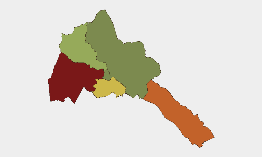
Highest-Risk Areas
Gash-Barka Region (risk 92) drives the country's highest sub-national threat score, reflecting its exposure to cross-border activity and regional instability. The Southern Red Sea Region (risk 75) presents secondary concentration, likely linked to maritime military activity and geopolitical proximity to conflict zones in the Horn of Africa. Debub Region (risk 68) shows elevated risk tied to structural border and regional factors. By contrast, Maekel Region (the capital area, risk 18) and the Northern Red Sea Region (risk 0) show substantially lower threat footprints, though travel restrictions and conscription pressures apply countrywide.
How GeoBit Would Assist
Security teams with personnel or assets in Eritrea should deploy Intel Sweep and global event feeds for real-time incident detection, coupled with multi-language X/Twitter and Telegram OSINT to capture early signals of unrest or civil mobilization before mainstream reporting. AOI Monitoring & Early Warning with persistent geospatial focus on Gash-Barka and the Southern Red Sea Region would provide persistent watch for border activity, military movement, or infrastructure changes. Routing & Network Analysis supports contingency planning for staff movement and supply-chain resilience in a low-transparency operating environment.
7-Day Outlook
No acute escalation is indicated in the near term; the security environment remains stable at current structural-risk levels. Ongoing regional tensions (Ethiopian border dynamics, Red Sea maritime activity, and internal conscription enforcement) will continue to drive elevated caution advisories. Monitoring should remain routine but consistent, with heightened sensitivity to cross-border signals and any changes in regional military posture that could cascade into Eritrean airspace or border zones.
Highest-Risk Areas — Ranked
| # | State / Region | Risk |
|---|---|---|
| 1 | Gash-Barka | 92 |
| 2 | Southern Red Sea Region | 75 |
| 3 | Debub Region | 68 |
| 4 | Anseba | 55 |
| 5 | Maekel Region | 18 |
| 6 | Northen Red Sea Region | 0 |
Sources
Previous Daily Briefs
A new Eritrea brief is written every day — each with its own risk map and downloadable CSV. Here's the last week; use the calendar to go further back.
📅 Browse every day by calendar →
Highlighted days have a brief. Tap a day for that day's map & analysis, or “csv” for that day's dataset ($5).
Atlas — our AI intelligence desk — emails them this snapshot personally. Nothing else, no list.