Situation Summary
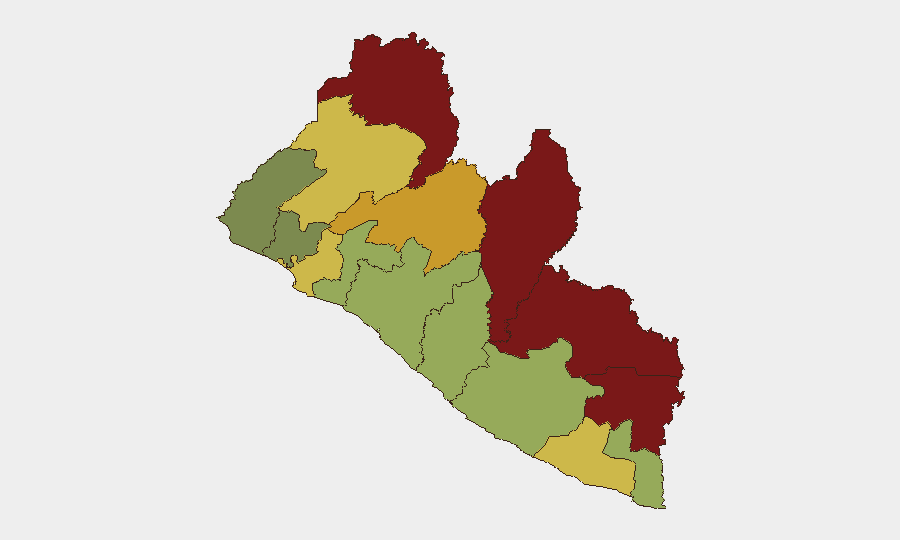
Liberia remains a low-risk country globally (rank #151, composite score 10) with no tracked security events during the reporting period. The security environment reflects a functioning state apparatus, with law enforcement and defense cooperation active, though significant subnational variation exists. The northeastern border region—particularly Nimba, Lofa, and Grand Gedeh counties—continues to drive aggregate risk scores; interior and coastal areas register materially lower threat levels. Trajectory remains stable absent new destabilizing events.
Key Developments
- Roberts International Airport, Margibi County — 19 October: Morocco delivered vehicles and supplies to the Armed Forces of Liberia via military C-130 transport; a second delivery flight was scheduled by 22 October, reflecting ongoing defense capacity-building.
- Monrovia — 18 October: Liberia's deputy police inspector general convened Nigerian military officers at LNP headquarters to discuss intelligence-sharing, cross-border security coordination, and technology integration—signaling elevated bilateral law-enforcement engagement.
- Monrovia — 16 October: River Gee County Senator Francis Dopoh requested Senate intervention regarding premature enforcement of Liberia's Cybercrime Law, citing absence of a mandated cybersecurity council and specialized unit. The dispute underscores institutional capacity gaps in cyber governance.
- Gbarnga and Panta District No. 4, Bong County — 15 October: Four suspects were forwarded to the Ninth Judicial Circuit Court on separate theft charges involving mineral extraction and mobile phone theft, reflecting ongoing petty-crime prosecution.
- Harper, Maryland County — 12–13 October: S. Tubman University reported an early-morning campus intrusion during which unknown individuals took keys, deflated a student-bus tire, and made threats ahead of midterm exams; the university requested police investigation.
Highest-Risk Areas
Nimba (92), Lofa (88), and Grand Gedeh (85) counties form a northeastern corridor driving Liberia's subnational risk profile. This region's elevation reflects historical cross-border trafficking vulnerabilities, limited state presence, and porous frontiers with Guinea and Sierra Leone. Bong County (72) and Gbarpolu (64) also warrant attention due to interior positioning and resource-extraction activity that can attract organized crime. Montserrado County (64), home to the capital, maintains elevated risk despite law enforcement concentration—reflecting urban crime density and migrant populations. Counties south and west of Monrovia (Grand Bassa, Margibi, Sinoe) register moderate-to-low scores, reflecting stronger state capacity and coastal accessibility.
How GeoBit Would Assist
Security teams operating in Liberia should employ AOI Monitoring & Early Warning on Nimba, Lofa, and Grand Gedeh counties to detect emerging trafficking, armed group activity, or organized crime patterns before they escalate. Intel Sweep and multi-language OSINT (X/Twitter, Telegram, local media) provide early signal of civil unrest, police operations, or cross-border incidents. Network & Actor Analysis supports mapping of trafficking and smuggling nodes; Routing & Network Analysis assists in identifying safer transit corridors and alternative border crossings for personnel and supply movement in the high-risk northeast.
7-Day Outlook
No significant deterioration is expected over the next seven days. Continued capacity-building with Morocco and Nigeria suggests stable institutional trajectory. Cybercrime law implementation disputes may generate low-level political friction but pose minimal direct security risk to corporate operations. Seasonal rainfall patterns may degrade road conditions in interior counties, affecting logistics more than security posture.
Highest-Risk Areas — Ranked
| # | State / Region | Risk |
|---|---|---|
| 1 | Nimba County | 92 |
| 2 | Lofa County | 88 |
| 3 | Grand Gedeh County | 85 |
| 4 | River Gee County | 83 |
| 5 | Bong County | 72 |
| 6 | Gbarpolu County | 68 |
| 7 | Grand Kru County | 65 |
| 8 | Montserrado County | 64 |
| 9 | Rivercess County | 58 |
| 10 | Sinoe County | 55 |
| 11 | Margibi County | 52 |
| 12 | Grand Bassa County | 48 |
Sources
Previous Weekly Briefs
A new Liberia brief is written every Monday, covering the week — each with its own risk map and downloadable CSV. Use the calendar to go further back.
- October 13, 2026
- October 6, 2026
- September 29, 2026
- September 22, 2026
- September 15, 2026
- September 8, 2026
- September 2, 2026
📅 Browse past briefs by calendar →
Highlighted days have a brief. Tap a day for that day's map & analysis, or “csv” for that day's dataset ($5).
Atlas — our AI intelligence desk — emails them this snapshot personally. Nothing else, no list.