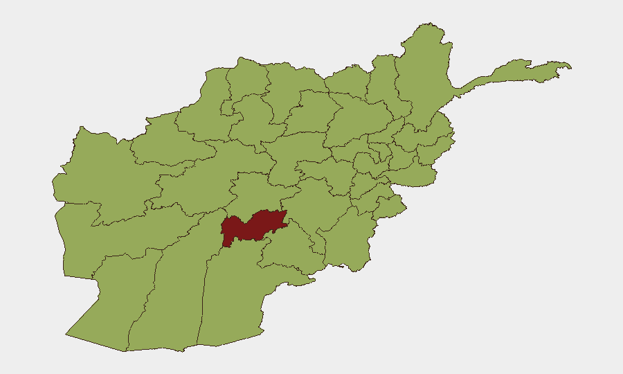
Situation Summary
Afghanistan remains a high-threat environment ranked #24 globally with a composite score of 77 across 44 tracked security events. Recent developments indicate intensifying state control measures alongside sustained civil tensions, particularly affecting media freedom and civil society space. Uruzgan Province continues to drive the highest localized risk (83.9), with Kabul and Herat provinces showing elevated threat levels tied to governance instability and factional competition. Current trajectory reflects a consolidation of authority by Taliban security apparatus amid international pressure and internal institutional friction.
Key Developments
- Kabul – 23 June 2026: Taliban security forces raided the headquarters of Tamadon TV (a Shia-owned broadcaster) and ordered a complete halt to transmissions. The station announced shutdown via public statement; this represents an escalation in Taliban media control and reflects tightening restrictions on non-aligned news outlets in the capital.
- Government statement – 24 June 2026: Government entity publicly rejected an unspecified proposal or position, suggesting internal discord or international pressure on policy matters; corroboration on substance is limited in available open-source reporting.
- UN investigation – 24 June 2026: UN initiated an investigative action related to unspecified Afghan events, indicating international scrutiny of governance or alleged violations.
- Afghan–European tensions – 24 June 2026: Public disapproval expressed by Afghan entities toward European positions; timing and specific subject remain unclear from available sources.
- Security Council statement – 24 June 2026: UN Security Council issued a public statement regarding Afghan affairs, underscoring continued international engagement and concern.
- Broader signaling: Multiple public statements from population, Belgium–Taliban entities, EU spokespeople, and journalist rejection of unnamed action (22 June) point to sustained pressure on Taliban governance from multiple directions and fragmented media/civil society response.
Highest-Risk Areas
Uruzgan Province's risk score (83.9) substantially exceeds all other regions and likely reflects persistent Taliban factional competition, residual anti-Taliban armed activity, and limited state capacity in remote areas. Kabul (59.2) and Herat (58.8) provinces drive secondary risk through governance dysfunction, civil-military friction, and international diplomatic pressure concentrated in administrative centers. The plateau of risk scores across nine provinces at 53.9–54.3 suggests a baseline of endemic instability across southern, eastern, and western regions—including Kandahar, Helmand, and Paktika—rooted in Taliban supply-line vulnerabilities, ISIS-K recruitment zones, and Pakistan border permeability. Media suppression in Kabul and civil-society contraction signal deteriorating institutional predictability, raising duty-of-care exposure for organizations operating in urban centers.
How GeoBit Would Assist
Corporate security teams should employ persistent Area-of-Interest (AOI) Monitoring & Early Warning on Kabul, Uruzgan, and Herat to detect changes in Taliban checkpoint operations, military movements, or media/NGO pressure campaigns affecting access and safety. Conflict & Military mapping and Network & Actor Analysis would clarify Taliban faction positions, supply routes, and ISIS-K presence in high-risk provinces to support route planning and facility site assessment. OSINT fusion (X/Twitter, Telegram, radio SIGINT) combined with multi-language search would track emerging restrictions on foreign business, visa policy changes, and security force targeting of specific sectors—critical for real-time duty-of-care adjustments.
7-Day Outlook
Taliban consolidation of internal security and media control is likely to continue, with intermittent public friction with international actors over governance and human-rights standards. Risk of secondary ISIS-K or anti-Taliban activity in Uruzgan and border provinces remains elevated and unforecast. Organizations should expect further operational friction in Kabul and provincial capitals; contingency planning for rapid staff relocation and asset protection should remain active.
Highest-Risk Areas — Ranked
| # | State / Region | Risk |
|---|---|---|
| 1 | Uruzgan Province | 83.9 |
| 2 | Kabul Province | 59.2 |
| 3 | Herat Province | 58.8 |
| 4 | Bamyan Province | 54.3 |
| 5 | Zabul Province | 53.9 |
| 6 | Kandahar Province | 53.9 |
| 7 | Ghazni Province | 53.9 |
| 8 | Paktika Province | 53.9 |
| 9 | Farah Province | 53.9 |
| 10 | Nimruz Province | 53.9 |
| 11 | Helmand Province | 53.9 |
| 12 | Jowzjan Province | 53.9 |
Previous Daily Briefs
A new Afghanistan brief is written every day — each with its own risk map and downloadable CSV. Here's the last week; use the calendar to go further back.
📅 Browse every day by calendar →
Highlighted days have a brief. Tap a day for that day's map & analysis, or “csv” for that day's dataset ($5).