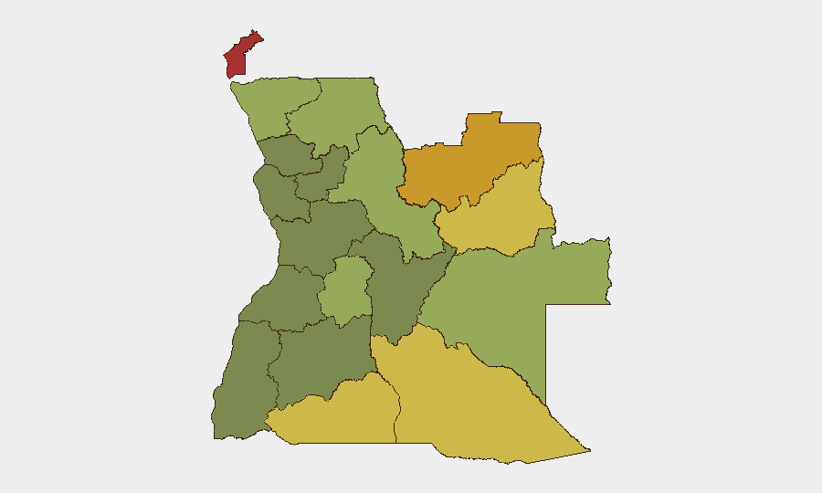
Situation Summary
Angola remains a stable, mid-range global security environment (rank #51) with no reported armed conflict, civil unrest, or critical infrastructure failures in the last 24–48 hours. The primary current drivers of disruption are wildfire activity across multiple provinces and heightened but routine security measures surrounding the African Chiefs of Defense Conference in Luanda through July 5. Risk concentration remains in the resource-rich eastern and northern border regions, while the capital and central zones maintain baseline stability without acute acute threats to corporate operations or expatriate populations.
Key Developments
- Luanda – July 5, 2026 – ACHOD 2026 (African Chiefs of Defense Conference) entered its conclusion phase with sustained reinforced checkpoints, perimeter security, and diplomatic traffic restrictions around key venues and hotels hosting 35+ delegations; no security incidents reported.
- Luanda and northern/eastern provinces – July 4–5, 2026 – Active wildfires across multiple regions generated visibility, air-quality, and secondary-road disruptions with potential localized evacuations; environmental hazard with secondary travel and emergency-services strain.
- Luanda Province – July 4–5, 2026 – Risk monitoring confirms elevated baseline due to political/commercial concentration, but no new armed incidents, mass crime, or civil unrest impacting foreigners or strategic infrastructure reported.
- Angola-wide – July 4–5, 2026 – Cross-checked open-source feeds (traditional media, social, security platforms) show no corroborated armed clashes, terrorist attacks, protests, or nationally significant crime targeting expatriates or assets.
- Angola-wide – July 4–5, 2026 – No reported major infrastructure failures (national power grid, airport, port) altering travel or operational risk at national scale; routine issues do not meet significance threshold.
Highest-Risk Areas
Cabinda (risk 78), Lunda Norte (72), and Lunda Sul (68) provinces drive Angola's sub-national risk profile due to ongoing armed-group activity, transnational smuggling networks, and resource competition. These northeastern and eastern border zones have historically hosted splinter factions (FLEC elements), artisanal mining disputes, and cross-border trafficking; the persistent elevation reflects structural factors rather than acute recent escalation. Cuando Cubango, Cunene, and Moxico provinces (risk 64, 62, 58 respectively) extend southern and eastern risk bands, though at lower intensity. Luanda and central provinces (Huambo, Malanje, Bié) show mid-to-lower risk, suitable for normal corporate presence with standard precautions.
How GeoBit Would Assist
Security teams should employ AOI (Area of Interest) Monitoring & Early Warning on Cabinda, Lunda Norte/Sul, and cross-border zones to detect armed-group movement, trafficking patterns, or civil unrest with persistent alerting. Conflict & Military tracking (force structure, weapons, battle mapping) combined with Network & Actor Analysis will identify key non-state actors and their operational tempo, enabling predictive assessment of flashpoint risk. Environmental & Health monitoring (wildfire tracking, air-quality data) integrated with Routing & Network Analysis allows real-time alternative-route planning when natural hazards disrupt primary corridors, protecting supply chains and personnel transit.
7-Day Outlook
ACHOD 2026 will conclude by July 6, after which Luanda's heightened security posture will normalize, reducing localized traffic and movement friction. Wildfire activity is expected to persist seasonally across northern and eastern provinces, with air quality and secondary-road closures remaining routine hazards rather than acute security threats. No indicators suggest imminent armed escalation, policy instability, or major crime waves in the near term; Angola's trajectory remains stable within its established regional risk profile.
Highest-Risk Areas — Ranked
| # | State / Region | Risk |
|---|---|---|
| 1 | Cabinda Province | 78 |
| 2 | Lunda Norte Province | 72 |
| 3 | Lunda Sul Province | 68 |
| 4 | Cuando Cubango Province | 64 |
| 5 | Cunene Province | 62 |
| 6 | Moxico Province | 58 |
| 7 | Zaire Province | 54 |
| 8 | Huambo Province | 50 |
| 9 | Uíge Province | 48 |
| 10 | Malanje Province | 42 |
| 11 | Bié Province | 35 |
| 12 | Huíla Province | 32 |
Sources
Previous Daily Briefs
A new Angola brief is written every day — each with its own risk map and downloadable CSV. Here's the last week; use the calendar to go further back.
📅 Browse every day by calendar →
Highlighted days have a brief. Tap a day for that day's map & analysis, or “csv” for that day's dataset ($5).
Atlas — our AI intelligence desk — emails them this snapshot personally. Nothing else, no list.