Situation Summary
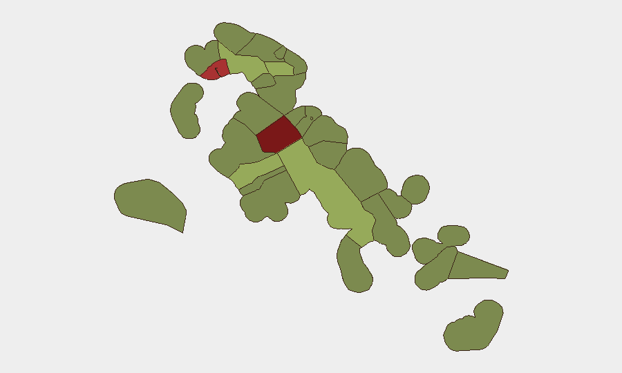
The Bahamas remains at composite threat level 21 globally, with New Providence (Nassau) and Freeport dominating risk exposure at scores of 92 and 78 respectively. No discrete security incidents have been verified in the past 24–48 hours; however, events from 1–3 August—including a double shooting in Nassau, a seaplane taxiing incident in Bimini, infrastructure failures at the Blue Hills Power Station, and shanty-town demolition tensions—indicate sustained underlying volatility. The U.S. State Department's 28 July Level 2 advisory citing armed robbery, burglary, and sexual assault in Nassau and Freeport remains operative and reflects the baseline threat environment.
Key Developments
- No new security incidents verified in the 24–48 hour window (4–6 August 2026). Open-source and social-media sweep by specialized risk platforms has not confirmed any discrete incidents clearly dated and corroborated to this period.
- Double shooting, West Bay Street, New Providence – 3 August 2026. One fatality and one hospitalization reported; police investigation active. Location is proximity to central Nassau commercial and hotel zones.
- Seaplane float damage, North Bimini Seaplane Base – 1 August 2026. Tropic Ocean Airways Cessna 208B immobilized during taxiing; all 10 passengers safely evacuated. Aircraft Accident Investigation Authority (AAIA) formal investigation ongoing under ICAO Annex 13 protocols.
- Blue Hills Power Station explosion and outages, New Providence – early August 2026. Lightning-triggered incident caused power disruption to residential areas, businesses, hotels, Nassau airport, and Princess Margaret Hospital, with ongoing service instability affecting critical infrastructure.
- House fire fatality, Palmetto Avenue, New Providence – early August 2026. Man deceased from severe burns; police investigation ongoing.
- Shanty-town demolition and assault, Montgomery area (Cowpen Road), New Providence – early August 2026. Government-led demolition of 64 of 67 structures; task-force chief assaulted during operation amid civil tensions over resident displacement.
Highest-Risk Areas
New Providence (score 92) and Freeport (score 78) account for the majority of tracked risk, driven by armed robbery, gang activity, and sexual assault concentrated in Nassau's "Over the Hill" area south of Shirley Street and downtown Freeport zones. Central Abaco (52), Central Andros (48), and Exuma (45) represent moderate secondary risk, though specific drivers are less densely documented in current cycles. Outer Family Islands (Cat Island, Mangrove Cay, South Abaco) carry substantially lower scores but remain part of the operational map for corporate assets and personnel movements.
How GeoBit Would Assist
Security teams would employ Intel Sweep and multi-language OSINT fusion to detect and corroborate emerging violent-crime and infrastructure incidents in real time, avoiding single-source dating errors and misdated rumor. AOI Monitoring & Early Warning with persistent geofenced alerts on New Providence and Freeport would flag shooting, robbery, or critical-infrastructure disruptions within operational zones before they circulate in mainstream media. Routing & Network Analysis would support contingency journey planning around high-risk neighborhoods and infrastructure bottlenecks (e.g., Blue Hills Power Station outages affecting airport access) to ensure continuity for personnel and asset movements.
7-Day Outlook
Absent new major incidents, baseline threat posture is likely to persist: chronic gang and street-crime pressure in Nassau and Freeport, periodic infrastructure strain, and sporadic unrest tied to socioeconomic tensions (demolitions, unemployment). Heightened summer tourism and cruise-port activity in early-to-mid August may attract opportunistic robbery and theft. Continuous monitoring of police reports and hospital-incident logs remains warranted to detect any shift in frequency or scale.
Highest-Risk Areas — Ranked
| # | State / Region | Risk |
|---|---|---|
| 1 | New Providence | 92 |
| 2 | City of Freeport | 78 |
| 3 | Central Abaco | 52 |
| 4 | Central Andros | 48 |
| 5 | Exuma | 45 |
| 6 | East Grand Bahama | 42 |
| 7 | South Andros | 38 |
| 8 | North Abaco | 35 |
| 9 | North Eleuthera | 33 |
| 10 | South Abaco | 32 |
| 11 | Cat Island | 30 |
| 12 | Mangrove Cay | 28 |
Sources
Previous Daily Briefs
A new Bahamas brief is written every day — each with its own risk map and downloadable CSV. Here's the last week; use the calendar to go further back.
📅 Browse every day by calendar →
Highlighted days have a brief. Tap a day for that day's map & analysis, or “csv” for that day's dataset ($5).
Atlas — our AI intelligence desk — emails them this snapshot personally. Nothing else, no list.