Situation Summary
Bangladesh faces elevated political and security volatility, with composite threat ranking at #22 globally (score 67/100). The event signal cluster from 26–28 July—including arrests, armed clashes, territory occupation, and a reported assassination attempt on the Prime Minister—indicates acute instability concentrated in the capital and surrounding regions. Security teams should treat the current 48-hour window as a high-alert period pending clarification of government response and opposition movement intentions.
Key Developments
- Dhaka Division, 27–28 July: Police conducted large-scale arrest operations, detaining 377–387 individuals across 41–45 cases in anti-crime sweeps (DMP reporting). Exact incident triggers remain unclear from available sources; confirmation against independent outlets is pending.
- Bangladesh-wide, 27–28 July: Multiple armed clashes reported between uprising/protest actors and police/security forces, per event signal logs. Specific casualty figures and geographic pinpoints unavailable; circulation suggests capital-region concentration.
- Dhaka Division, 27 July: Territory occupation reported; scale and duration not yet specified in available open reporting.
- Bangladesh (National level), 28 July: Government announced expulsion/deportation action; target group and timeline require urgent clarification for duty-of-care assessment.
- Shariatpur District, 27 July: Police detention activity logged; connection to capital-region unrest unclear.
- Border areas (Kushtia/Daulatpur, early period): BGB reportedly intercepted irregular cross-border movement of eight unidentified individuals; may indicate trafficking or security-related activity.
Note: Open reporting on these events remains sparse and unauthenticated by secondary sources. Signals derive primarily from event aggregation; corporate teams should cross-check with embassy advisories, local media (Bangla and English), and direct in-country contacts before operational decisions.
Highest-Risk Areas
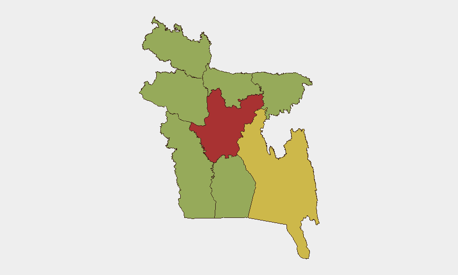
Dhaka Division dominates the risk profile (76.5/100), driven by protest/political activity, police operations, and armed incidents concentrated in the capital and adjacent districts. Chittagong Division (65.0) presents secondary risk, likely linked to port-area labor and occasional militant activity; Rangpur (59.8) and Khulna (58.4) show elevated but lower acute threat. The three southernmost divisions (Barishal, Sylhet, Mymensingh) remain below the national mean, indicating risk concentration in the urban-industrial belt and northern border zones.
How GeoBit Would Assist
Intel Sweep and OSINT Fusion (X/Twitter, Telegram, local Bangla news, YouTube activist channels) would rapidly triangulate event locations, timeline accuracy, and actor identities within the arrest and armed-clash signals. AOI Monitoring & Early Warning on Dhaka, Chittagong port, and border crossings would flag new protest mobilization, checkpoints, or movement restrictions affecting staff commute and supply chains in real time. Network & Actor Analysis would map opposition, government, and security-force statements to assess escalation risk and likely next flashpoints for the coming week.
7-Day Outlook
Political tension is expected to remain elevated through early August, with risk of further clashes if government enforcement operations continue or opposition movements expand demonstrations. International statement activity (evident from recent diplomatic rejections/disapprovals) suggests potential for sanctions, visa restrictions, or travel advisories that may affect personnel rotations and local hiring. Security teams should implement heightened situational awareness protocols, establish staff communication trees, and pre-position contingency evacuation/safe-haven procedures in Dhaka and Chittagong.
Highest-Risk Areas — Ranked
| # | State / Region | Risk |
|---|---|---|
| 1 | Dhaka Division | 76.5 |
| 2 | Chittagong Division | 65 |
| 3 | Rangpur Division | 59.8 |
| 4 | Khulna Division | 58.4 |
| 5 | Mymensingh Division | 48.3 |
| 6 | Rajshahi Division | 46.8 |
| 7 | Barishal Division | 46.5 |
| 8 | Sylhet Division | 46.5 |
Sources
Previous Daily Briefs
A new Bangladesh brief is written every day — each with its own risk map and downloadable CSV. Here's the last week; use the calendar to go further back.
📅 Browse every day by calendar →
Highlighted days have a brief. Tap a day for that day's map & analysis, or “csv” for that day's dataset ($5).
Atlas — our AI intelligence desk — emails them this snapshot personally. Nothing else, no list.