Situation Summary
Barbados remains in a stable security environment with no confirmed incidents, civil unrest, infrastructure disruption, or travel-risk events in the 24–48-hour window of 26–27 August 2026. The composite national threat score of 3 (ranked #182 globally) reflects low overall risk, though routine criminal activity—assault, drug trafficking—continues at baseline levels in earlier reporting (22–25 August). No emerging security triggers have materialized; normal law-enforcement activity and commercial operations are proceeding without reported disruption.
Key Developments
- No discrete security incidents confirmed in Barbados for 26–27 August 2026. Available web sources and regional security briefs contain no reports of protests, riots, violent crime spikes, infrastructure failures, or travel corridor disruptions during this 48-hour window.
- Routine law-enforcement activity noted in prior reporting (22–25 August). Court filings and police activity records from Barbados Today document assault and drug-trafficking cases, but these fall outside the current 24–48-hour window and do not indicate new or escalating incidents on 26–27 August.
- Event activity on 26 August at Bay Street Esplanade confined to commercial/entertainment programming (ticket sales, event promotion on CBC/Mornin' Barbados broadcast), with no security advisories or disruption indicators attached.
- No civil unrest, protest activity, or political instability signaled in current surveillance. Regional and local news snapshots show no organized demonstrations, roadblocks, or community conflict in the reporting window.
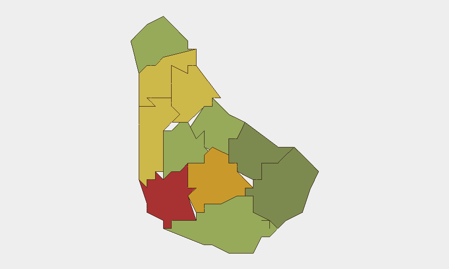
- Saint Michael, Saint George, and Saint James parishes continue to register the highest sub-national risk scores, but this reflects baseline crime/incident prevalence rather than acute emerging events on 26–27 August.
Highest-Risk Areas
Saint Michael (risk 78), Saint George (risk 72), and Saint James (risk 68) drive Barbados's sub-national risk profile. These parishes—encompassing the capital Bridgetown, surrounding urban districts, and tourism-adjacent coastal zones—carry elevated property crime, street-level assault, and drug-trafficking activity relative to the island's rural parishes. Saint Andrew, Saint Peter, and Saint Joseph follow (risk scores 65, 62, 58), suggesting risk is concentrated in populated and economic-hub areas. The steep drop-off to Saint Philip (risk 28) and Saint John (risk 35) indicates that southern and isolated parishes experience materially lower incident frequency and severity.
How GeoBit Would Assist
A security team with personnel or assets in Barbados should employ AOI Monitoring & Early Warning on the highest-risk parishes (Saint Michael, Saint George, Saint James) to detect emerging civil unrest, protest activity, or crime spikes in real time. Intel Sweep and multi-language web/social OSINT (including X/Twitter and local news feeds) would provide 24-hour situational awareness of any new incidents, political statements, or labor disputes that precede formal reporting. Routing & Network Analysis capabilities can identify alternative travel paths and safe corridors should any localized disruption occur on primary routes between key corporate or residential zones.
7-Day Outlook
No acute security triggers are visible for the near term. Absent new political tensions, gang violence escalation, or natural-disaster impact, Barbados is expected to remain in a low-threat, stable operational environment through early September. Routine crime monitoring and standard duty-of-care protocols remain appropriate; formal alert escalation is not warranted at this time.
Highest-Risk Areas — Ranked
| # | State / Region | Risk |
|---|---|---|
| 1 | Saint Michael | 78 |
| 2 | Saint George | 72 |
| 3 | Saint James | 68 |
| 4 | Saint Andrew | 65 |
| 5 | Saint Peter | 62 |
| 6 | Saint Joseph | 58 |
| 7 | Saint Thomas | 52 |
| 8 | Saint Lucy | 48 |
| 9 | Christ Church | 42 |
| 10 | Saint John | 35 |
| 11 | Saint Philip | 28 |
Sources
Previous Daily Briefs
A new Barbados brief is written every day — each with its own risk map and downloadable CSV. Here's the last week; use the calendar to go further back.
- August 24, 2026
- August 21, 2026
- August 18, 2026
- August 16, 2026
- August 14, 2026
- August 12, 2026
- August 10, 2026
📅 Browse every day by calendar →
Highlighted days have a brief. Tap a day for that day's map & analysis, or “csv” for that day's dataset ($5).
Atlas — our AI intelligence desk — emails them this snapshot personally. Nothing else, no list.