Situation Summary
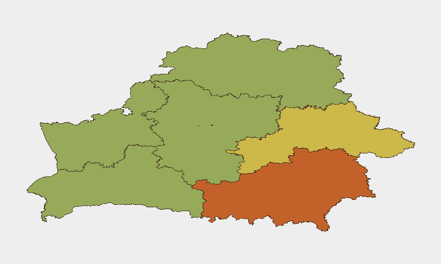
Belarus remains a low-threat environment globally (rank #120, composite score 8) with no tracked security incidents in the 24-hour review window. However, sub-national risk concentration in eastern regions—particularly Homyel (75), Minsk (68), and Mahilyow (62)—reflects ongoing border-security activity and proximity to the Ukraine conflict zone. Recent cross-border incidents (airspace incursion, border-crossing suspensions) signal elevated operational tempo in frontier areas, though the overall security posture for corporate assets and personnel in Belarus has not materially degraded.
Key Developments
No confirmed security incidents were identified in the last 24–48 hours from independent sources meeting standard corroboration criteria.
Unverified signals detected in Belarus media suggest:
- Border-security tightening near the Ukraine frontier and territorial defense exercises reported by Belarus news outlets, but occurrence timing within the last 48 hours is not independently confirmed.
- Police handling phone-scam reports and minor traffic incidents in Minsk, dated to early July and not within the current review window.
Recent context (last 7 days, not current):
- 2026-08-06: Vilnius International Airport halted operations overnight following airspace incursion by suspected smuggler balloons from Belarus—indicating elevated cross-border activity.
- 2026-07-31: Pāternieki border crossing with Belarus suspended due to information-system failure; remained closed as of 2026-08-03.
These recent events reflect operational strain in border-management systems and irregular cross-border activity but do not constitute active security threats to corporate operations within Belarus proper.
Highest-Risk Areas
Homyel Region (75) and Minsk (68) carry the highest composite risk scores, driven primarily by proximity to the Ukraine border and concentration of critical national infrastructure. Mahilyow Region (62) follows, continuing the concentration of risk along the eastern frontier. By contrast, western regions (Hrodna, Brest) and the northern Vitsebsk Region register significantly lower scores (45–55), reflecting distance from conflict adjacency and lower operational tempo. Risk gradient correlates with border proximity and cross-border incident frequency rather than internal instability.
How GeoBit Would Assist
Corporate security teams with personnel or assets in high-risk eastern regions should employ AOI Monitoring & Early Warning with persistent geofencing around Homyel and Mahilyow to detect escalating cross-border activity or security incidents in real time. Intel Sweep and multi-language OSINT fusion (X/Twitter, Telegram, local news feeds) would establish a verified baseline of border-management changes, police activity, and territorial exercises—filtering out unconfirmed rumors and enabling duty-of-care confidence. Conflict & Military tracking (force structure, exercise timing) would provide 48–72-hour warning of heightened alert states before they affect commercial operations or staff movement.
7-Day Outlook
No material escalation in Belarus-specific security threats is forecast for the next seven days. However, the recent cluster of cross-border incidents (balloon incursions, border-crossing suspensions) suggests sustained irregular activity in frontier zones; corporate teams should maintain heightened vigilance for secondary effects (transport delays, curfews, airspace restrictions) rather than direct security threats. Personnel in Homyel and Mahilyow should confirm contingency routing and communication protocols with GeoBit's Routing & Network Analysis capability to ensure operational continuity if border-crossing delays recur.
Highest-Risk Areas — Ranked
| # | State / Region | Risk |
|---|---|---|
| 1 | Homyel Region | 75 |
| 2 | Minsk | 68 |
| 3 | Mahilyow Region | 62 |
| 4 | Brest Region | 55 |
| 5 | Hrodna Region | 52 |
| 6 | Minsk Region | 48 |
| 7 | Vitsebsk Region | 45 |
Sources
Previous Daily Briefs
A new Belarus brief is written every day — each with its own risk map and downloadable CSV. Here's the last week; use the calendar to go further back.
📅 Browse every day by calendar →
Highlighted days have a brief. Tap a day for that day's map & analysis, or “csv” for that day's dataset ($5).
Atlas — our AI intelligence desk — emails them this snapshot personally. Nothing else, no list.