Situation Summary
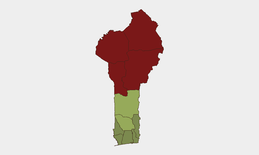
Benin remains a relatively stable West African state, ranked #45 globally on GeoBit's composite threat index (score 41). No verified security incidents have been reported in open sources within the last 24–48 hours. The country's risk profile is heavily concentrated in its northern departments, where proximity to conflict zones in Niger, Burkina Faso, and northern Nigeria creates persistent structural vulnerability, while southern and coastal regions maintain substantially lower threat exposure.
Key Developments
No confirmed security, conflict, civil-unrest, crime, or infrastructure incidents in Benin have been verified in open sources for the period of 12–14 July 2026. Recent GeoBit event signals (dated 12–14 July) tagged to Benin predominantly reference internal political communications and statements rather than security events. Open-source monitoring (news, social media, and web sources) has not identified time-specific, independently corroborated incidents meeting GeoBit's reporting threshold. Some signals may reflect misattribution to Benin City, Edo State, Nigeria—a distinct location—rather than events within the Republic of Benin.
Highest-Risk Areas
Northern Benin drives the country's overall risk profile. Alibori Department (risk score 92) and Atakora Department (risk score 88) face sustained cross-border pressure from terrorist and armed groups operating in Niger and Burkina Faso, with historical incursions and recruitment activity. Donga (85) and Borgou (83) departments present similar exposure. By contrast, central and southern departments—Zou (45), Collines (42), and Plateau (38)—carry moderate structural risk, while coastal departments including Littoral (25) and Ouémé (22) remain substantially lower-threat zones. Risk in the north reflects geography and transnational criminal/militant networks rather than active, ongoing armed conflict within Benin itself at this time.
How GeoBit Would Assist
Security teams managing personnel or assets in Benin should employ GeoBit's AOI Monitoring & Early Warning capability to establish persistent watches over high-risk northern departments (Alibori, Atakora, Donga, Borgou), with alerting thresholds set for cross-border incursions, armed-group recruitment, or sudden displacement. Intel Sweep, multi-language OSINT, and sentiment analysis across regional news, social media, and Telegram channels can detect early signals of escalation before they crystallize into incidents. Routing & Network Analysis and GIS & Spatial Analysis support duty-of-care planning, allowing teams to identify safer alternative travel corridors and safe havens within the country by real-time risk layering.
7-Day Outlook
Benin's near-term security trajectory is expected to remain stable, with no indicators of imminent state-level instability or large-scale civil unrest. Northern departments will continue to face low-level transnational pressure from armed groups operating primarily in Niger and Burkina Faso; however, Benin's security forces have maintained border integrity and prevented major spillover. Routine vigilance for cross-border militant activity and monitoring of political statements (several noted in recent event signals) are warranted; any material escalation would likely manifest first in open-source signals in the north and should be detected by sustained AOI monitoring.
Highest-Risk Areas — Ranked
| # | State / Region | Risk |
|---|---|---|
| 1 | Alibori Department | 92 |
| 2 | Atakora Department | 88 |
| 3 | Donga Department | 85 |
| 4 | Borgou Department | 83 |
| 5 | Zou Department | 45 |
| 6 | Collines Department | 42 |
| 7 | Plateau Department | 38 |
| 8 | Kouffo Department | 35 |
| 9 | Mono Department | 32 |
| 10 | Atlantique Department | 28 |
| 11 | Littoral | 25 |
| 12 | Ouémé Department | 22 |
Sources
Previous Daily Briefs
A new Benin brief is written every day — each with its own risk map and downloadable CSV. Here's the last week; use the calendar to go further back.
📅 Browse every day by calendar →
Highlighted days have a brief. Tap a day for that day's map & analysis, or “csv” for that day's dataset ($5).
Atlas — our AI intelligence desk — emails them this snapshot personally. Nothing else, no list.