Situation Summary
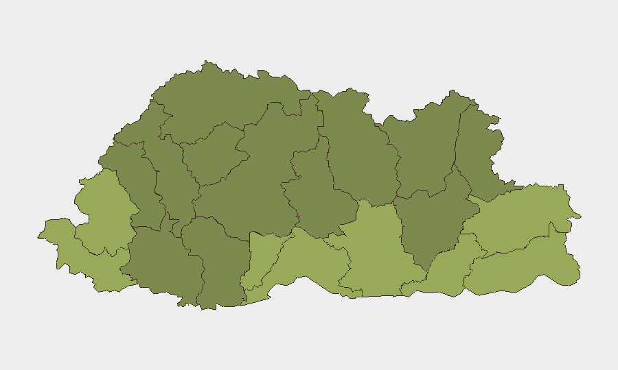
Bhutan maintains a stable national security environment with no verified incidents reported in the last 24–48 hours. The country's composite threat score remains low (3/100) globally, with no active tracked conflict or civil-unrest events. Risk concentration is localized to six southern and eastern border districts (Samtse, Sarpang, Haa, Pemagatshel, Samdrup Jongkhar, and Tsirang), which reflect elevated vulnerability scores but no imminent escalation indicators as of 2 August 2026.
Key Developments
- National — 2026-08-01 to 2026-08-02: No security incidents, civil unrest, or infrastructure disruptions verified in the last 24–48 hours; country-level stability assessment remains unchanged.
- Border districts (Samtse, Sarpang, Haa) — 2026-08-01 to 2026-08-02: Localized vulnerability persists in southern and eastern frontier regions, but no new specific incident was reported during the reporting window.
No additional discrete security events met verification thresholds for recency and significance during the review period.
Highest-Risk Areas
The southern border districts of Samtse (risk 58), Sarpang (55), and Haa (52) rank highest, reflecting chronic vulnerability to cross-border movements, informal trade, and wildlife trafficking rather than active conflict. Eastern districts including Pemagatshel (50), Samdrup Jongkhar (48), and Tsirang (45) similarly show elevated risk profiles tied to limited state capacity and remote geography. These areas warrant monitoring for illicit flows and civil-order stressors, but no current escalation is indicated. The northern and central districts (Gasa, Lhuntse, Wangdue Phodrang) register lower risk and remain stable.
How GeoBit Would Assist
Security teams with personnel or assets in Bhutan's border districts should deploy AOI Monitoring & Early Warning on Samtse, Sarpang, and Haa to detect emerging patterns in movement, trade, or civil-order disruption. OSINT fusion and multi-language search (including Bhutanese and regional sources) would provide continuous verification of incident reports and early signals of change. Conflict, crime, and border-territory search capabilities enable targeted intelligence sweeps on trafficking networks, informal cross-border activity, and localized tensions that may not surface in mainstream reporting. Periodic GIS & Spatial Analysis and satellite imagery review of high-risk districts would inform duty-of-care assessments and route-planning decisions.
7-Day Outlook
No near-term security escalation is forecast for Bhutan at the national level. Border districts will continue to present baseline vulnerabilities to illicit flows and informal activity, but no catalyst for rapid change is visible in the current intelligence window. Continued weekly monitoring of Samtse, Sarpang, and Haa is prudent for organizations with operations in those areas.
Highest-Risk Areas — Ranked
| # | State / Region | Risk |
|---|---|---|
| 1 | Samtse District | 58 |
| 2 | Sarpang District | 55 |
| 3 | Haa District | 52 |
| 4 | Pemagatshel District | 50 |
| 5 | Samdrup Jongkhar District | 48 |
| 6 | Tsirang District | 45 |
| 7 | Zhemgang District | 42 |
| 8 | Trashigang District | 40 |
| 9 | Mongar District | 38 |
| 10 | Gasa District | 35 |
| 11 | Lhuntse District | 32 |
| 12 | Wangdue Phodrang District | 30 |
Sources
Previous Daily Briefs
A new Bhutan brief is written every day — each with its own risk map and downloadable CSV. Here's the last week; use the calendar to go further back.
📅 Browse every day by calendar →
Highlighted days have a brief. Tap a day for that day's map & analysis, or “csv” for that day's dataset ($5).
Atlas — our AI intelligence desk — emails them this snapshot personally. Nothing else, no list.