Situation Summary
Bolivia remains under a 90-day state of emergency as security forces conduct nationwide operations to clear road blockades that have persisted for over six weeks, driven by protests against fuel subsidy cuts and deteriorating economic conditions. Cochabamba Department (risk 64.3) is the highest-risk sub-national zone, with rural associations allied to former President Evo Morales maintaining control of key production routes despite partial agreements with national trade unions. The security environment is volatile: military and police have expanded powers to detain, disperse gatherings, and enforce restrictions on alcohol and large assemblies in designated "red zones," creating acute risk of sudden confrontations in urban areas and along major transport corridors. Supply shortages of food, fuel, and medical supplies persist, particularly affecting La Paz and El Alto, while road conditions remain fluid as security forces open some routes while new blockades emerge elsewhere.
Key Developments
- La Paz & El Alto, 24–25 June: Security forces continuing active operations to clear road blockades under state of emergency; UK FCDO advisory warns of expanded military deployment and risk of armored vehicle use in urban areas if blockades persist.
- Cochabamba Department (Chapare region), 24–25 June: Rural associations aligned with former President Morales maintaining control of key access routes, refusing to stand down despite partial union agreements; routes 4 and 24 remain under blockade control.
- Intercity corridors (La Paz–Copacabana, Desaguadero, Oruro, Cochabamba, Potosí, Rurrenabaque), 24–25 June: UK FCDO advising against all travel on these major highways "until further notice" due to continuing blockades and active security operations; rapid route status changes reported.
- Multi-department supply crisis, 24–25 June: CNN and DW report ongoing shortages of food, fuel, and medical supplies across La Paz, El Alto, Cochabamba, Oruro, Potosí, and Chuquisaca as a direct result of blockade persistence.
- Urban enforcement zones (La Paz, Cochabamba, major cities), 24–25 June: Updated FCDO guidance notes alcohol bans and restrictions on large gatherings in "red zones," with police and military empowered to enforce; heightened risk of night-time enforcement actions in nightlife and plaza areas.
- National transport authority updates, 24–25 June: Bolivian road authority issuing frequent blockade status updates, indicating fluid conditions and requiring travelers to monitor local media continuously for route changes.
Highest-Risk Areas
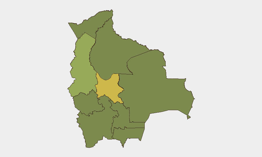
Cochabamba (64.3) and La Paz (46.2) drive the national threat profile. Cochabamba's elevated risk reflects sustained control of rural blockades by associations loyal to former President Morales, who reject state-of-emergency enforcement and control access to production areas in the strategically important Chapare region. La Paz's risk stems from the concentration of security operations, urban confrontations, and the supply crisis affecting the capital and neighboring El Alto. The remaining departments (Potosí, Tarija, Pando, Beni, Oruro, Chuquisaca, Santa Cruz) all score 34.3, reflecting secondary but persistent protest activity, blockades, and shortages linked to the national emergency.
How GeoBit Would Assist
Security teams should employ AOI Monitoring & Early Warning (persistent watch on Cochabamba Chapare routes, La Paz checkpoint areas, and intercity corridors) coupled with Routing & Network Analysis to identify safe alternative supply and personnel movement paths as primary routes change. Multi-language OSINT fusion (monitoring local media, Telegram protest channels, and Bolivian authority road-status feeds) provides real-time blockade status and enforcement-action alerts, while event tracking and sentiment analysis flag escalation signals within protest communities before major confrontations occur.
7-Day Outlook
The 90-day emergency framework is likely to intensify enforcement operations on major routes over the coming week, particularly around La Paz, El Alto, and Cochabamba, with sporadic clearances followed by new blockades. Supply shortages are expected to persist and potentially worsen if blockades in the Chapare region hold. Risk of sudden, localized violence and detentions around enforcement actions remains acute; corporate operations should maintain heightened vigilance on personnel movement and supply logistics.
Highest-Risk Areas — Ranked
| # | State / Region | Risk |
|---|---|---|
| 1 | Cochabamba | 64.3 |
| 2 | La Paz | 46.2 |
| 3 | Potosí | 35.3 |
| 4 | Tarija | 34.3 |
| 5 | Pando | 34.3 |
| 6 | Beni | 34.3 |
| 7 | Oruro | 34.3 |
| 8 | Chuquisaca | 34.3 |
| 9 | Santa Cruz | 34.3 |
Previous Daily Briefs
A new Bolivia brief is written every day — each with its own risk map and downloadable CSV. Here's the last week; use the calendar to go further back.
📅 Browse every day by calendar →
Highlighted days have a brief. Tap a day for that day's map & analysis, or “csv” for that day's dataset ($5).