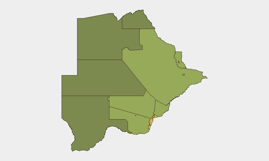
Situation Summary
Botswana remains a relatively low-threat environment in absolute terms (composite threat score 4; no tracked events in the current window). Open-source reporting over the past 24–48 hours shows no clearly verified new security, crime, unrest, infrastructure, or travel incidents. Risk is geographically concentrated in major urban and mining centres, with Gaborone, the South-East District, and Lobatse accounting for the highest sub-national scores; baseline crime, cross-border movement, and localized labour tensions remain the primary drivers rather than acute instability.
Key Developments
No discrete security events meeting verification criteria (Botswana-specific, clearly dated within 24–48 hours, independently confirmed) have been identified in the current reporting window (6 August 2026).
Available open-source coverage does not support attribution of new incidents to the past two days. Earlier developments—including cross-border crime and migration alerts tied to South African unrest (late June 2026), internal Botswana Patriotic Front mediation (early July 2026), and defence cooperation discussions with Angola (early August, exact date unconfirmed in open sources)—fall outside the 24–48-hour threshold required for "Key Developments" reporting.
Security teams with operational presence should continue to monitor routine risk vectors (petty crime in Gaborone and Lobatse, informal cross-border movement in border districts, and labour-related gatherings in mining zones) using standard protocols rather than escalating response to new acute triggers at this time.
Highest-Risk Areas
Gaborone (risk 72), South-East District (68), and Lobatse (65) comprise the top tier of sub-national risk and reflect concentrations of economic activity, population density, and cross-border connectivity. Francistown and Jwaneng follow, each driven by mining operations and informal-economy density. Risk in these zones is attributable to property crime, vehicle theft, informal settlement unrest, and proximity to South African border dynamics rather than to political instability or organized conflict. Rural and northern districts (North-West, Central, North-East) register substantially lower risk profiles, indicating that security incidents and routine threats are heavily urbanized phenomena.
How GeoBit Would Assist
Security teams operating in Botswana should deploy AOI Monitoring & Early Warning on Gaborone, Lobatse, and Francistown to detect emerging labour disputes, informal-settlement tensions, or cross-border movement spikes in near-real time. Intel Sweep (global event feeds, social media OSINT, multi-language search) combined with Network & Actor Analysis enables continuous tracking of criminal networks and labour organizers active in high-risk districts. Routing & Network Analysis supports duty-of-care teams in identifying secure movement corridors around Gaborone and mining zones, particularly for personnel with cross-border travel requirements.
7-Day Outlook
No imminent acute security events are forecast based on current open-source indicators. Routine baseline risks—petty crime, informal-settlement disputes, and cross-border informal activity—will persist in urban zones, particularly Gaborone and Lobatse, without mitigation changes. Monitoring cadence should remain standard unless AOI alerts or new event signals trigger escalation protocols.
Highest-Risk Areas — Ranked
| # | State / Region | Risk |
|---|---|---|
| 1 | Gaborone | 72 |
| 2 | South-East District | 68 |
| 3 | Lobatse | 65 |
| 4 | Francistown | 62 |
| 5 | Jwaneng | 61 |
| 6 | Selebi Phikwe | 58 |
| 7 | Southern District | 55 |
| 8 | Kgatleng District | 50 |
| 9 | Kweneng District | 48 |
| 10 | North-East District | 45 |
| 11 | Central District | 42 |
| 12 | North-West District | 38 |
Sources
Previous Daily Briefs
A new Botswana brief is written every day — each with its own risk map and downloadable CSV. Here's the last week; use the calendar to go further back.
📅 Browse every day by calendar →
Highlighted days have a brief. Tap a day for that day's map & analysis, or “csv” for that day's dataset ($5).
Atlas — our AI intelligence desk — emails them this snapshot personally. Nothing else, no list.