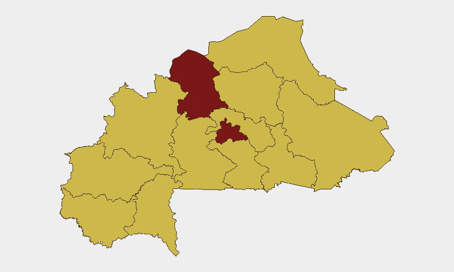
Situation Summary
Burkina Faso remains at composite threat rank #23 globally with a score of 94, reflecting persistent instability across the North and Centre regions. Recent diplomatic ruptures—including the expulsion of EU diplomats and closure of consular services—signal deteriorating state cohesion and international relations. No verified kinetic incidents were reported in the 24–48 hours prior to 16 July 2026, though elevated threat signals from public statements and military posturing suggest underlying tension. The security environment remains fragmented by region, with northern and central zones sustaining the highest risk profiles.
Key Developments
- Ouagadougou, 15 July 2026 – Burkina Faso authorities ordered two EU diplomats to leave the country within 72 hours; embassy and consular services were subsequently closed, following the government's decision to rupture diplomatic relations with the EU.
- Burkina Faso–Benin Border (Koualou area), 14 July 2026 onward – Joint border patrols between Beninese and Burkinabè military forces commenced to strengthen counterterrorism and border control operations.
- Ouagadougou, 19 July 2026 – A public statement was issued by the Burkina Faso government; specific content and implications remain under assessment.
- Military posturing signal, 19 July 2026 – A conventional military force event was recorded involving Burkina Faso and Tunisia; operational details and intent are not yet corroborated.
- Regional threat escalation, 17–18 July 2026 – Multiple threat signals were detected, including government-level public statements (17 July) and cross-actor threats involving Africa and Burkina Faso (18 July); contextual analysis is ongoing.
- No kinetic incidents confirmed, 13–16 July 2026 – Despite elevated signal activity, no verified attacks or clashes were independently documented in the prior 48-hour windows.
Highest-Risk Areas
The North and Centre regions carry equal composite risk scores of 95.5, substantially above all other tracked zones. Both regions sustain the security apparatus's core concern, driven by persistent armed group activity, weak territorial control, and recurring displacement. Nine additional regions (Upper-Basins through East) cluster at risk score 65.5, indicating widespread but secondary-order vulnerability. The geographic concentration of top-tier risk in the North and Centre suggests that organizations with personnel or assets in Ouagadougou and surrounding central zones face elevated exposure; operations extending into northern provinces require heightened vigilance and contingency planning.
How GeoBit Would Assist
Security teams should employ AOI Monitoring & Early Warning capabilities on the North, Centre, and border regions to detect emerging kinetic activity and mass-casualty events in real time. OSINT fusion and corroboration across X/Twitter, Telegram, radio SIGINT, and YouTube intelligence streams will disambiguate official statements and threat signals, reducing false-positive escalation. Conflict & Military force-structure tracking combined with Network & Actor Analysis will map command relationships and intentions behind recent military posturing toward Tunisia and diplomatic ruptures, supporting duty-of-care decisions on expat presence and asset relocation.
7-Day Outlook
Diplomatic rupture and military signaling suggest the government is consolidating control and recalibrating external posture, likely in response to internal or regional pressure. Kinetic risk in the near term remains episodic rather than systemic; however, the absence of confirmed violence in the last 48 hours should not be read as de-escalation. Organizations should anticipate further public statements and border activity within the next seven days and maintain contingency protocols for rapid staff movement or asset protection.
Highest-Risk Areas — Ranked
| # | State / Region | Risk |
|---|---|---|
| 1 | North | 95.5 |
| 2 | Centre | 95.5 |
| 3 | Upper-Basins | 65.5 |
| 4 | Boucle du Mouhoun | 65.5 |
| 5 | Central-West | 65.5 |
| 6 | Central-South | 65.5 |
| 7 | Central-East | 65.5 |
| 8 | Waterfalls | 65.5 |
| 9 | Southwest | 65.5 |
| 10 | Sahel | 65.5 |
| 11 | Central-North | 65.5 |
| 12 | East | 65.5 |
Sources
Previous Daily Briefs
A new Burkina Faso brief is written every day — each with its own risk map and downloadable CSV. Here's the last week; use the calendar to go further back.
📅 Browse every day by calendar →
Highlighted days have a brief. Tap a day for that day's map & analysis, or “csv” for that day's dataset ($5).
Atlas — our AI intelligence desk — emails them this snapshot personally. Nothing else, no list.