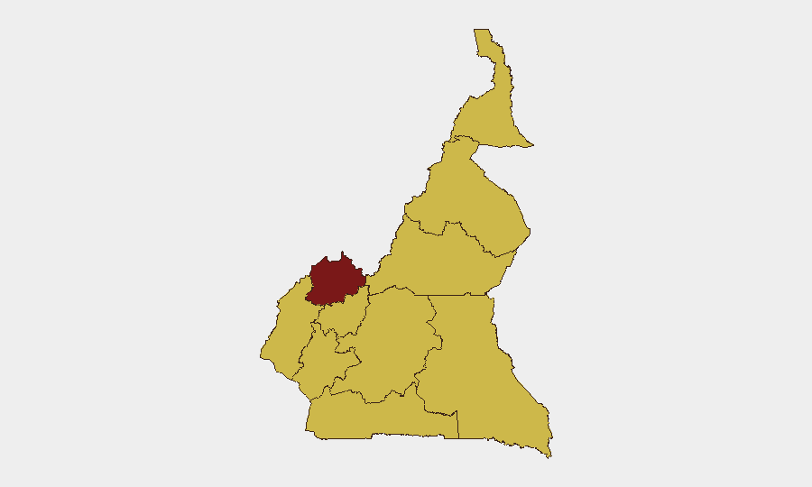
Situation Summary
Cameroon remains a composite mid-tier threat (global rank #23, score 91) with acute regional concentration in the Northwest and mounting pressure from Boko Haram in the Far North. The past 48 hours have witnessed escalating hostage-taking linked to armed groups, fresh jihadist violence in Mayo-Tsanaga, and reported security-force arrests in anglophone zones, indicating simultaneous friction across separatist, counterinsurgency, and governance axes. Humanitarian deterioration and informal-sector deaths underscore compounding risks to civilians and business continuity.
Key Developments
- Douala-Bonabéri Port, Littoral Region (2 July 2026). Defence Minister Joseph Beti Assomo inaugurated a new Rapid Intervention Battalion (BIR) base consolidating maritime operations and logistical centers. Signals intensified elite-force presence and likelihood of more frequent security checkpoints and operations around the port and harbor zone.
- Mayo-Tsanaga Division, Far North Region (2–3 July 2026). Public Health Minister visit to Mokolo Regional Annex Hospital confirmed multiple civilians wounded in recent Boko Haram attacks. Confirms active jihadist threat in rural northern communities with cross-border implications.
- Abductions and Hostage Incidents, Cameroon (3 July 2026). Two distinct abduction/hostage events reported: one targeting a priest, another targeting Franciscan religious personnel. Suggests targeting of high-profile or symbolic figures and heightened volatility in regions hosting religious or aid organizations.
- Northwest Region, Public Statements (3 July 2026). Multiple counter-statements and official responses between Northwest separatist actors and Cameroon government recorded on 3 July. Reflects ongoing rhetorical and political confrontation in the highest-risk sub-national zone.
- West Cameroon Arrests (2–3 July 2026). Civil-society groups posted allegations of "illegal arrests" in anglophone regions within the preceding 48 hours, citing suppression of rights. Indicates recent security-force detention operations contributing to political tensions, though specific locations and case details remain partially unverified.
- Kye-Ossi, South Region (2 July 2026). Informal gold-mining fatality (drowning) at an unregulated extraction site near the Equatorial Guinea border. Highlights poor safety and emergency-response infrastructure in border-zone informal economies where expatriate and local workers operate.
- National Humanitarian Alerts (2–3 July 2026). NGO messaging on social platforms flagged escalating food insecurity and compounding shocks to civilian populations. Worsening humanitarian conditions create recruitment and grievance vulnerability, particularly in conflict-affected regions.
Highest-Risk Areas
The Northwest Region (93.6 score) drives national risk due to sustained separatist mobilization, armed-group presence, and government counteroperations. The Centre, Southwest, West, Littoral, Adamawa, South, Far-North, North, and East regions all score 63.6–66.6, indicating that risk is geographically dispersed but concentrated along Boko Haram infiltration corridors (Far North), anglophone conflict zones (Southwest/Northwest/West), and major urban/port infrastructure (Littoral, Centre). The hostage-takings and arrest incidents of the past 48 hours span both separatist and religious-targeting patterns, suggesting multiple threat vectors rather than a single dominant driver.
How GeoBit Would Assist
Security teams would deploy AOI Monitoring & Early Warning on Northwest, Far North (Mayo-Tsanaga), and Littoral logistics nodes to detect emerging incidents and militant movement patterns. Network & Actor Analysis of separatist factions and Boko Haram cells would clarify targeting intent and operational capacity. Routing & Network Analysis would provide real-time alternate travel planning and safe-corridor identification for personnel and supply movement, particularly between Douala, Yaoundé, and conflict zones.
7-Day Outlook
Hostage incidents and separatist statements suggest sustained pressure in the Northwest; Boko Haram activity in the Far North is likely to persist given recent rural targeting. Port and government security consolidation (BIR) may increase checkpoint friction and operational tempo in Douala and surrounding routes. Humanitarian deterioration and arrest allegations will reinforce local grievances, elevating indirect risk to foreign workers and supply chains through economic instability and civil unrest.
Highest-Risk Areas — Ranked
| # | State / Region | Risk |
|---|---|---|
| 1 | Northwest | 93.6 |
| 2 | Centre | 66.6 |
| 3 | Southwest | 63.6 |
| 4 | West | 63.6 |
| 5 | Littoral | 63.6 |
| 6 | Adamawa | 63.6 |
| 7 | South | 63.6 |
| 8 | Far-North | 63.6 |
| 9 | North | 63.6 |
| 10 | East | 63.6 |
Sources
Previous Daily Briefs
A new Cameroon brief is written every day — each with its own risk map and downloadable CSV. Here's the last week; use the calendar to go further back.
📅 Browse every day by calendar →
Highlighted days have a brief. Tap a day for that day's map & analysis, or “csv” for that day's dataset ($5).