Situation Summary
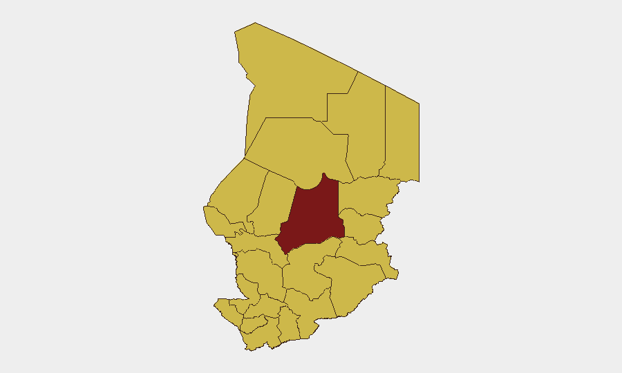
Chad ranks #22 globally in GeoBit's threat composite (score 89), with 10 tracked events concentrated in the last 48 hours. The security picture reflects concurrent hostage incidents (bandit and terrorist activity), cross-border tension with Sudan (territorial occupation), diplomatic friction with the US, and an unconfirmed hepatitis E health event. Batha region dominates sub-national risk at 92.2, while 11 other regions cluster at 62.2, indicating concentrated but geographically dispersed threat activity.
Key Developments
- 2026-06-30 · Abduct/Hijack/Hostage · Terrorist faction: Hostage incident reported; location and victim profile not yet specified in available signals.
- 2026-06-28 · Abduct/Hijack/Hostage · Bandit group vs Chad: Second hostage/abduction event within 48 hours; sub-national location unconfirmed in signal data.
- 2026-06-30 · Occupy Territory · Sudan-Chad border: Sudanese forces reported occupying Chadian territory; underscores unresolved border dispute and cross-border military presence.
- 2026-06-30 · Diplomatic tensions · Chad vs US: Public statements exchanged; substance of dispute not detailed in available signals; may reflect broader Sahel geopolitical realignment.
- 2026-06-30 · Abduct/Hijack/Hostage · Chadian actor vs Libya (two incidents): Cross-border hostage incidents involving Libyan territory; suggests trafficking, ransom networks, or criminal/militant activity spanning Chad-Libya frontier.
- 2026-06-30 · Student/Public Statement event: Involvement of student actors; context unclear from signal metadata alone.
- Recent · Health event: Hepatitis E reported in Chad; epidemiological scope and case count not specified in current brief data.
Highest-Risk Areas
Batha region (92.2) is the primary driver of sub-national risk, likely reflecting active militant/bandit operations, cross-border incursions, or state-capacity gaps. The remaining 11 regions—spanning the Sahel periphery (Ennedi-Ouest, Wadi Fira, Ouaddaï, Sila, Salamat, East Ennedi), central dry belt (Kanem, Lac), and capital zone (N'Djamena, Hadjer-Lamis, Chari-Baguirmi)—all score 62.2, suggesting baseline instability across pastoral, remote, and urban zones. This distribution indicates that hostage risk, criminal activity, and health hazards are not concentrated in a single zone but reflect national fragility.
How GeoBit Would Assist
Intel Sweep & OSINT Fusion would synthesize dispersed event signals (hostage incidents, border incursions, diplomatic statements) with real-time X/Telegram feeds and multi-language sources to clarify actor intent, victim profiles, and cross-border networks. AOI Monitoring & Early Warning on Batha and the Chad-Sudan and Chad-Libya borders would provide persistent alerting when hostage or occupation events escalate. GIS & Spatial Analysis layered with Conflict & Military mapping would track force positioning, displacement routes, and safe corridors for personnel or asset evacuation. Network & Actor Analysis would identify bandit, terrorist, and trafficking cell structure to inform risk stratification for specific locations and populations.
7-Day Outlook
Hostage incidents are likely to persist if underlying criminal/militant networks remain active and uncontested. Border tension with Sudan may intensify if occupation is not diplomatically resolved within days. Health event (hepatitis E) requires monitoring for outbreak scale; if cases rise, cross-border displacement and humanitarian operations will compound security complexity.
Highest-Risk Areas — Ranked
| # | State / Region | Risk |
|---|---|---|
| 1 | Batha | 92.2 |
| 2 | Ennedi-Ouest | 62.2 |
| 3 | Wadi Fira | 62.2 |
| 4 | Ouaddaï | 62.2 |
| 5 | Sila | 62.2 |
| 6 | Salamat | 62.2 |
| 7 | East Ennedi | 62.2 |
| 8 | Kanem | 62.2 |
| 9 | Lac | 62.2 |
| 10 | N'Djamena | 62.2 |
| 11 | Hadjer-Lamis | 62.2 |
| 12 | Chari-Baguirmi | 62.2 |
Sources
Previous Daily Briefs
A new Chad brief is written every day — each with its own risk map and downloadable CSV. Here's the last week; use the calendar to go further back.
📅 Browse every day by calendar →
Highlighted days have a brief. Tap a day for that day's map & analysis, or “csv” for that day's dataset ($5).