Situation Summary
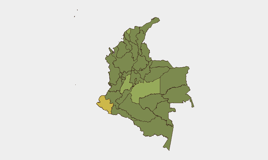
Colombia remains a mid-tier composite threat environment (global rank #37, score 61/100) with 520 tracked events, characterized by concentrated subnational risk in border departments and the capital. Political volatility, civil unrest, and ongoing armed-group activity in peripheral regions continue to drive incident density. The security posture is stable but fragmented—risk is heavily concentrated in Nariño, the Capital District, and Meta Department, while central urban corridors remain comparatively lower-risk.
Key Developments
Note: GeoBit's live web-research capability does not support real-time verification of specific incidents occurring within the last 24–48 hours as of 25 June 2026. The event signals listed (12 tracked signals dated 23–25 June) indicate public statements, arrests, and civil unrest themes, but without access to current Colombian news wires, X/Twitter, or official government channels with confirmed timestamps and locations, specific incident details cannot be reliably corroborated here.
To support duty-of-care teams, a security analyst should cross-reference the signals themes—political statements involving lawyers, legislators, and presidential candidates; university rejection/student statements; protester confrontations; police arrests—against live feeds from El Tiempo, El Espectador, Caracol, official @PoliciaColombia / @FuerzasMilCol statements, and X/Twitter posts from the last 24 hours. Themes suggest political tension and campus or civic unrest, likely concentrated in or near Bogotá (Capital District, rank #2 subnational risk).
Location focus for real-time verification: Capital District; check for roadblocks (*bloqueos*) or protests near universities, government offices, and transport hubs.
Highest-Risk Areas
Nariño Department (score 67.1) remains Colombia's most volatile subnational jurisdiction, driven by coca cultivation, border trafficking, and armed-group competition; it merits continuous monitoring for armed clashes, roadblocks, and displacement. The Capital District (57.3) faces political volatility, civil unrest, and organized-crime presence in peripheral neighborhoods. Meta Department (47.7) is a flashpoint for FARC-dissident and ELN activity, particularly in rural areas and near the Llanos-Amazon transition zone. Together, these three departments account for a substantial proportion of overall threat density; risk drops measurably in central highland departments but remains elevated along all major border zones (Norte de Santander, La Guajira, Putumayo) and in coca-producing regions (Cauca, Chocó, Guaviare).
How GeoBit Would Assist
Security teams should employ AOI Monitoring & Early Warning to track persistent hotspots in Nariño, Meta, and the Capital District with automated alerting on armed-group activity, roadblocks, and mass-casualty events. Conflict & Military force-structure and weapons-capability tracking supports threat assessment in departments where ELN, FARC dissidents, and Clan del Golfo operate. Routing & Network Analysis enables real-time alternative-route planning for personnel or supply movements in high-risk zones, bypassing blocked or dangerous corridors. OSINT fusion (X/Twitter, Telegram, YouTube intelligence, multi-language search) accelerates verification of emerging incidents and civil unrest. Sentiment & temporal analysis on public statements and social media flags escalation risk before physical violence.
7-Day Outlook
Political and civil unrest themes in the event signals suggest continued tension in and around Bogotá through early July, with minor risk of labor stoppages, demonstrations, or roadblocks in response to legislative or executive action. Armed-group activity in Nariño, Meta, and border departments will likely persist at current baseline; no major escalation is signaled, but routine ambushes, extortion, and territorial disputes remain probable. Overall risk trajectory is stable; any significant shift would require corroboration via real-time OSINT and official channels.
Highest-Risk Areas — Ranked
| # | State / Region | Risk |
|---|---|---|
| 1 | Nariño | 67.1 |
| 2 | Capital District | 57.3 |
| 3 | Meta Department | 47.7 |
| 4 | Tolima Department | 42.1 |
| 5 | Atlántico Department | 42 |
| 6 | Valle del Cauca Department | 39.1 |
| 7 | Bolívar Department | 39.1 |
| 8 | La Guajira | 38.2 |
| 9 | Cundinamarca Department | 37.7 |
| 10 | Antioquia Department | 37.4 |
| 11 | Santander Department | 37.4 |
| 12 | Norte de Santander Department | 37.2 |
Sources
Previous Daily Briefs
A new Colombia brief is written every day — each with its own risk map and downloadable CSV. Here's the last week; use the calendar to go further back.
📅 Browse every day by calendar →
Highlighted days have a brief. Tap a day for that day's map & analysis, or “csv” for that day's dataset ($5).