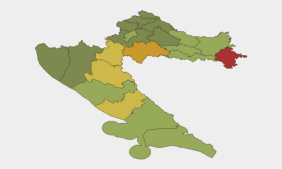
Situation Summary
Croatia maintains stable national security conditions with no active civil unrest, armed conflict, or infrastructure crises. The last 24–48 hours have registered routine localized criminal incidents (assault, burglary, traffic accidents) concentrated in coastal and eastern border regions, consistent with baseline crime patterns. Overall risk trajectory remains flat; no systemic destabilization indicators are present.
Key Developments
- Nova Mokošica (Dubrovnik area) – 21 July 2026: A 65-year-old man was seriously injured after being pushed down stairs and beaten following a parking dispute. Police arrested a 32-year-old suspect on suspicion of attempted murder.
- Island of Vir (Zadar County) – 20–21 July 2026: Three male suspects were detained in connection with three separate violent assaults on the island, resulting in multiple injuries including at least one serious case.
- Medulin waterfront (Istria County) – 20–21 July 2026 (incident dated 17–18 July, follow-up reporting current): Police continue investigation into a violent assault on two Slovenian nationals (aged 26, 23), one with serious injuries.
- Pakrac (Požega-Slavonia County) – c. 21 July 2026: A 29-year-old male was arrested on suspicion of attempted burglary and theft of church property; criminal investigation ongoing.
- Retkovci–Andrijaševci road (Vukovar-Srijem County) – c. 21 July 2026: A 21-year-old driver sustained serious injuries in a single-vehicle accident; police are investigating criminal circumstances.
- Dubrovnik traffic incidents – 20 July 2026: A pedestrian was injured in a traffic accident on Ulica žrtava s Dakse. Police report 28 traffic accidents on Dubrovnik roads over seven days, indicating elevated routine traffic risk in the area.
Highest-Risk Areas
Vukovar-Srijem County (risk 78) and Sisak-Moslavina County (risk 72) remain the highest-risk regions, driven by proximity to the Serbian border, legacy conflict-related sensitivities, and persistent property crime. Karlovac and Lika-Senj counties (risk 68 and 65 respectively) show elevated scores linked to similar geographic and post-conflict factors. The coastal belt—particularly Zadar and Šibenik-Knin counties (risk 55 and 62)—shows elevated localized violent crime, especially during high tourist season. Zagreb (risk 50) and Split-Dalmatia (risk 48) register moderate risk; current incident clustering in Dubrovnik and Zadar reflects seasonal tourism-related congestion and interpersonal violence rather than organized crime or political targeting.
How GeoBit Would Assist
Security teams operating in Croatia should leverage AOI Monitoring & Early Warning on highest-risk counties (Vukovar-Srijem, Sisak-Moslavina) to detect emerging unrest or organized activity; Intel Sweep and multi-language OSINT (X/Twitter, Telegram, local media) to track localized crime trends and inflammatory rhetoric in real time; and Routing & Network Analysis to identify safe transit corridors away from current incident concentrations in Dubrovnik and Zadar. Sentiment & temporal analysis on local sources would flag escalation in interpersonal violence clusters before they spread.
7-Day Outlook
No material escalation is expected. Localized violent crime and traffic incidents will likely persist at baseline rates through the tourist season. Border tensions with Serbia remain subdued; no new political or protest activity is forecast. Duty-of-care teams should maintain standard security protocols for coastal and eastern regions but require no emergency response measures.
Highest-Risk Areas — Ranked
| # | State / Region | Risk |
|---|---|---|
| 1 | Vukovar-Srijem County | 78 |
| 2 | Sisak-Moslavina County | 72 |
| 3 | Karlovac County | 68 |
| 4 | Lika-Senj County | 65 |
| 5 | Šibenik-Knin County | 62 |
| 6 | Brod-Posavina County | 58 |
| 7 | Zadar County | 55 |
| 8 | Osijek-Baranja County | 52 |
| 9 | City of Zagreb | 50 |
| 10 | Split-Dalmatia County | 48 |
| 11 | Požega-Slavonia County | 45 |
| 12 | Virovitica-Podravina County | 42 |
Sources
Previous Daily Briefs
A new Croatia brief is written every day — each with its own risk map and downloadable CSV. Here's the last week; use the calendar to go further back.
📅 Browse every day by calendar →
Highlighted days have a brief. Tap a day for that day's map & analysis, or “csv” for that day's dataset ($5).
Atlas — our AI intelligence desk — emails them this snapshot personally. Nothing else, no list.