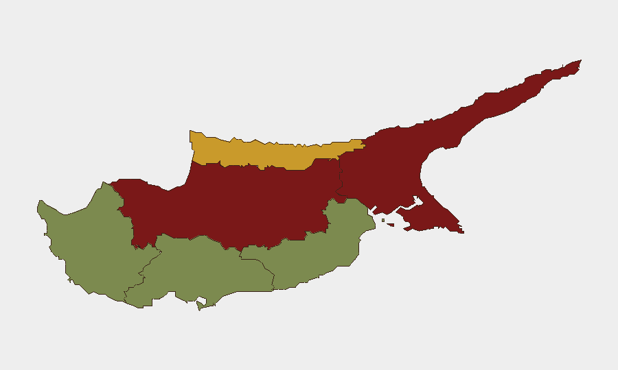
Situation Summary
Cyprus remains a low-threat destination overall (global rank #172, composite score 4), but security incidents are concentrated in the divided island's northern regions, particularly Nicosia and Famagusta. Over the past 24–48 hours, violent crime, fraud, and infrastructure incidents have emerged across multiple districts, indicating episodic but not systemic instability. The risk profile is heavily skewed toward the partition line and Turkish-controlled areas; southern and western regions retain markedly lower threat exposure.
Key Developments
- Limassol city center, 2026-08-12 (03:30): An explosion damaged a building, nearby property, and a parked vehicle; the target was believed to be nightclub or party-related premises. Investigation ongoing; exact motive and responsibility unconfirmed.
- Larnaca Airport, 2026-08-12: Police arrested a 37-year-old man under court warrant on fraud charges involving 20 cases and approximately €827,400 in reported losses.
- Nicosia/Aglantzia, 2026-08-12 (early hours): A road collision left a 16-year-old seriously injured after a vehicle struck and dragged a personal mobility device.
- Nationwide, 2026-08-12: Police overnight preventive operations yielded two arrests and 368 complaints/citations for traffic violations and public-order offenses across urban areas.
- Agios Ioannis Malountas, 2026-08-12: A forest fire was reported fully under control; no casualty or displacement data released.
- Paphos District/Holy Monastery of Agios Neophytos (2026-08-08 to present): A 51-year-old monk was remanded for six days in connection with an attempted murder investigation; two people injured in the incident.
Highest-Risk Areas
Nicosia (risk 92) and Famagusta (risk 88) dominate the threat landscape, reflecting their proximity to the UN buffer zone and Turkish-controlled northern Cyprus; both regions experience elevated rates of property crime, inter-communal tensions, and occasional violent incidents. Kyrenia (risk 72) follows at moderate-high risk. In contrast, southern and western districts—Larnaca (28), Limassol (22), and Paphos (18)—register substantially lower composite scores, though recent isolated incidents (the Limassol explosion and Paphos monastery violence) underscore that no area is entirely incident-free. Risk concentration in the north reflects historical partition dynamics and reduced government presence; southern zones benefit from stronger institutional control and tourism-driven security investment.
How GeoBit Would Assist
Security teams with personnel or assets in Cyprus should deploy AOI Monitoring & Early Warning on Nicosia and Famagusta to track emerging protest activity, property crime clusters, and inter-communal incidents in near-real time. Intel Sweep and multi-language OSINT (including X/Telegram feeds and local police reports) enable continuous horizon-scanning for violent crime, fraud rings, and infrastructure threats. Risk & Threat Assessment and GIS & Spatial Analysis allow duty-of-care teams to model safe zones, optimize travel routing via Routing & Network Analysis, and brief staff on area-specific hazards before deployment.
7-Day Outlook
No imminent large-scale security deterioration is forecast; Cyprus remains stable at the national level. Isolated incidents—robbery, fraud, occasional violence, and infrastructure threats—will likely persist at current frequencies in urban centers and northern zones. Monitoring of protest activity near British military bases and continued police operations against property-crime networks should be expected.
Highest-Risk Areas — Ranked
| # | State / Region | Risk |
|---|---|---|
| 1 | Nicosia | 92 |
| 2 | Famagusta | 88 |
| 3 | Kyrenia | 72 |
| 4 | Larnaca | 28 |
| 5 | Limassol | 22 |
| 6 | Paphos | 18 |
Sources
Previous Daily Briefs
A new Cyprus brief is written every day — each with its own risk map and downloadable CSV. Here's the last week; use the calendar to go further back.
📅 Browse every day by calendar →
Highlighted days have a brief. Tap a day for that day's map & analysis, or “csv” for that day's dataset ($5).
Atlas — our AI intelligence desk — emails them this snapshot personally. Nothing else, no list.