Situation Summary
DR Congo remains the 10th-highest-risk country globally, driven primarily by persistent insurgency and armed-group activity across eastern provinces. The immediate security picture is characterized by baseline armed-group presence and civil conflict rather than major new escalations in the last 48 hours; however, a concurrent Bundibugyo-strain Ebola outbreak—now spreading beyond Ituri into North Kivu and South Kivu—is compounding health-security strain and limiting operational access for humanitarian and security personnel. Political tension persists in Kinshasa following mid-June protest clashes, with elevated alert levels around key government sites. Overall trajectory remains unstable but not acutely deteriorating in the short term.
Key Developments
- Ituri Province Ebola growth (18–19 June): WHO and humanitarian agencies reported ~29–21 new Ebola cases in successive 24-hour periods, bringing confirmed cases to approximately 896 with over 230 deaths, with more than 90% concentrated in Ituri. Insecurity and population displacement are actively hampering outbreak response operations.
- Cross-provincial Ebola spread (18–19 June): Bundibugyo-strain Ebola cases now confirmed in North Kivu and South Kivu beyond the initial Ituri epicenter, signaling regional health containment risk. Uganda continues to report 19 linked cases with no recent new infections.
- Health infrastructure strain (18–19 June): Over 500 Ebola treatment beds activated in Ituri, >2,000 tests conducted daily, and contact-tracing reaching ~75% of known contacts; operations remain disrupted by armed-group presence and movement restrictions.
- Eastern DRC armed-group activity (18–19 June): Persistent baseline armed-group presence and elevated civil-conflict risk noted across North Kivu, Tshopo, and Lower Uele; no independently verified large-scale clashes, massacres, or major new displacement events in the last 48 hours.
- Kinshasa political alert (18–19 June): Authorities remain on high alert around parliamentary and key government sites following 15 June security-force dispersal of anti-constitutional-reform protesters; no additional large-scale confrontations verified in last 24–48 hours, but sudden protest disruptions remain a risk.
- Human-rights commission statement (19 June): African Commission on Human and Peoples' Rights published findings highlighting ongoing armed conflict, forced displacement, sexual violence in eastern DRC, and overcrowded conditions at Makala Central Prison in Kinshasa, reinforcing structural detention and conflict-related abuse risks.
Highest-Risk Areas
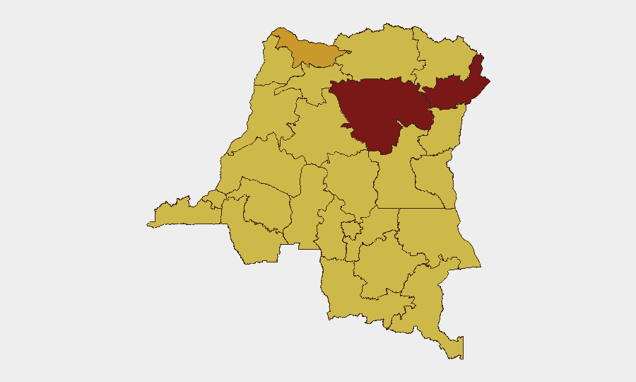
Ituri Province (risk score 100) is the dominant threat driver, combining active armed-group presence with the epicenter of the Ebola outbreak and health-system collapse. Tshopo (85) follows as a secondary eastern corridor of instability. Nord-Ubangi, Maniema, and a tier of provinces at risk 70 form a contiguous band of armed-group activity and displacement across the eastern and northern frontier zones. North Kivu (70) and Lualaba (70) represent persistent conflict and criminal-group risk, respectively. The concentration of risk in the eastern provinces reflects both ADF and M23-linked activity, cross-border spillover from Uganda and Rwanda, and severely degraded state authority.
How GeoBit Would Assist
Security teams operating in or supporting DR Congo should deploy AOI Monitoring & Early Warning on Ituri, North Kivu, and Tshopo to detect escalations in armed-group activity or health-system collapse in real time. Routing & Network Analysis can identify safe movement corridors around Ebola-affected health zones and areas of active armed-group presence. OSINT Fusion & Corroboration via X/Twitter, Telegram, and multi-language search will surface emerging protest activity or political instability in Kinshasa ahead of major disruptions.
7-Day Outlook
Near-term trajectory is likely to remain stable but fragile. Ebola containment efforts will dominate health-sector access and logistics constraints, particularly in Ituri and expanding secondary sites. Armed-group activity is expected to persist at baseline levels with low probability of major escalation in the next week; however, political tension in Kinshasa poses a secondary disruption risk if constitutional reforms advance. Cross-border screening and health protocols for Uganda and regional neighbors will remain essential.
Highest-Risk Areas — Ranked
| # | State / Region | Risk |
|---|---|---|
| 1 | Ituri | 100 |
| 2 | Tshopo | 85 |
| 3 | Nord-Ubangi | 71.2 |
| 4 | Maniema | 70 |
| 5 | Sud-Ubangi | 70 |
| 6 | Équateur | 70 |
| 7 | Mongala | 70 |
| 8 | Lower Uele | 70 |
| 9 | Tshuapa | 70 |
| 10 | Upper Uele | 70 |
| 11 | North Kivu | 70 |
| 12 | Lualaba | 70 |
Sources
Previous Daily Briefs
A new DR Congo brief is written every day — each with its own risk map and downloadable CSV. Here's the last week; use the calendar to go further back.
📅 Browse every day by calendar →
Highlighted days have a brief. Tap a day for that day's map & analysis, or “csv” for that day's dataset ($5).