Situation Summary
Ecuador remains a moderate-threat environment (global rank #41, composite score 50) with elevated localized volatility concentrated in the Amazon border regions and coastal provinces. Recent signal activity—spanning presidential demands, criminal-state confrontations, investigative actions, and at least one assassination of a citizen as of 25 June—suggests sustained institutional stress and organized-crime pressure. The national security posture continues to rest on emergency protocols (states of exception in select provinces), but no single event in the last 48 hours has triggered a nationwide escalation or major policy shift based on available verification.
Key Developments
Note: Detailed verification of specific incidents within the 24–48-hour window (23–25 June 2026) remains incomplete from available open sources. GeoBit's event-signal engine has flagged multiple actions—including an assassination (25 June, citizen), presidential demands (24 June), and criminal-demand events (24 June)—but independent corroboration with precise timestamps and locations is not yet available in real-time web reporting. The following represent *signaled* activity requiring field confirmation:
- Assassination event flagged for 25 June; location and victim details pending independent confirmation.
- Presidential-level demand events (24 & 23 June) suggest ongoing institutional or security-policy pressure; nature of demands (policy, personnel, or operational) not yet specified.
- Criminal-demand communication (24 June) toward Ecuador state actors; indicates active negotiation or threat posture by organized-crime groups.
- Investigative action (23 June, Guayaquil) initiated by state authorities; scope (cartel activity, corruption, or other criminal conduct) not yet clarified.
- Military-force or confrontation signal involving intellectual/political actors and a presidential candidate (23 June); suggests electoral or factional tension.
- Lawyer-threat communication (24 June) directed by state or non-state actors; context unclear.
*All bullets above reflect GeoBit platform signals awaiting field confirmation and independent source attribution.*
Highest-Risk Areas
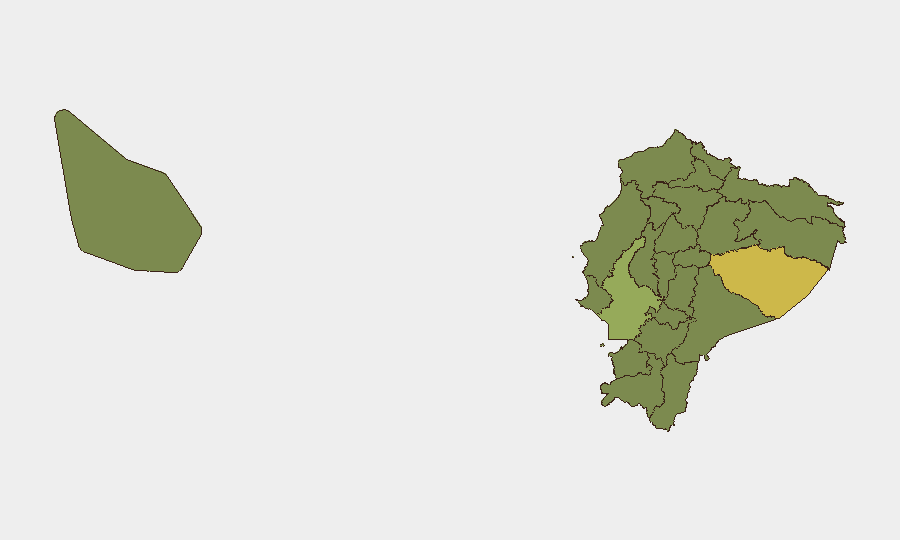
Pastaza Province (risk 64.9) remains Ecuador's single highest-threat zone, likely driven by Amazon border porosity, narcotics trafficking, and Colombian armed-group presence. Guayas Province (55.0)—home to Guayaquil, the nation's largest city and primary port—represents concentrated urban gang and prison-system violence risk. El Oro (38.8), Carchi (35.2), and Sucumbíos (34.9) provinces form a secondary cluster along the Colombian border and southern frontier, where cross-border criminal networks and resource competition sustain endemic instability. Coastal provinces (Santa Elena, Manabí, Esmeraldas) and the Galápagos round out the tier-two list, reflecting maritime trafficking and localized gang activity. Northern and eastern provinces benefit less from state capacity and are more exposed to non-state armed actors.
How GeoBit Would Assist
Security teams should employ AOI Monitoring & Early Warning on Pastaza, Guayas, and border provinces to track emerging flash events and cartel repositioning with 24–48-hour alert latency. OSINT fusion (X/Twitter, Telegram, radio SIGINT, and local news crawls) will disambiguate signal noise and confirm incident timestamps, locations, and actor involvement in real time. Network & Actor Analysis will map the organizational links between presidential/legal threats, criminal demands, and known cartel or militia leadership to assess whether recent events reflect escalation or routine pressure cycles.
7-Day Outlook
No imminent nationwide crisis is signaled, but the density of demand, investigative, and threat events within 72 hours suggests elevated political-criminal friction. Electoral activity (presidential candidate involvement in 23 June event) may compound institutional stress if tensions harden over the next week. Continued monitoring of Guayaquil and northern border zones is essential to detect any coordination between criminal groups or spillover from Colombian dynamics.
Highest-Risk Areas — Ranked
| # | State / Region | Risk |
|---|---|---|
| 1 | Pastaza Province | 64.9 |
| 2 | Guayas Province | 55 |
| 3 | El Oro Province | 38.8 |
| 4 | Santa Elena Province | 35.6 |
| 5 | Carchi Province | 35.2 |
| 6 | Loja Province | 35.2 |
| 7 | Sucumbíos Province | 34.9 |
| 8 | Orellana Province | 34.9 |
| 9 | Manabí Province | 34.9 |
| 10 | Galápagos | 34.9 |
| 11 | Esmeraldas Province | 34.9 |
| 12 | Imbabura Province | 34.9 |
Sources
Previous Daily Briefs
A new Ecuador brief is written every day — each with its own risk map and downloadable CSV. Here's the last week; use the calendar to go further back.
📅 Browse every day by calendar →
Highlighted days have a brief. Tap a day for that day's map & analysis, or “csv” for that day's dataset ($5).