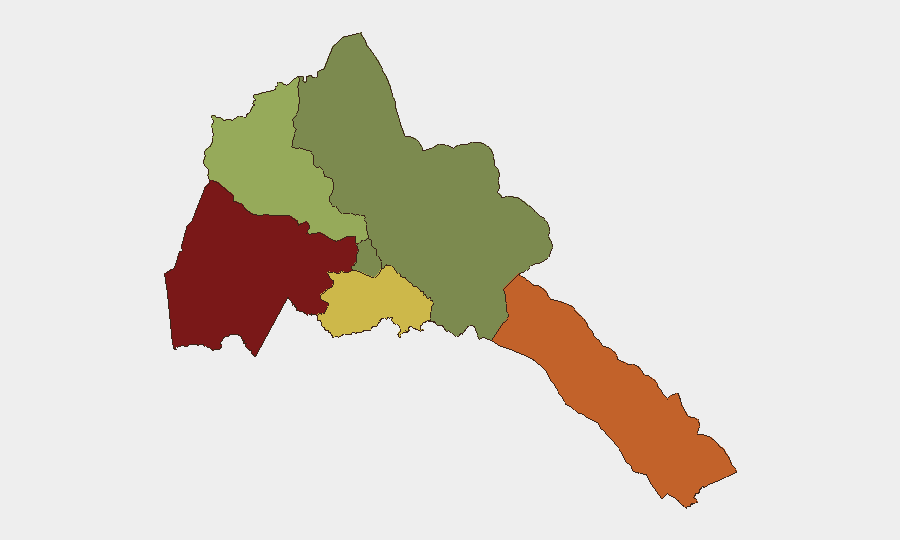
Situation Summary
Eritrea remains a low-frequency-incident environment with a composite threat score of 2 and no tracked security events recorded in the past 24–48 hours. A strike or boycott event was flagged on 2026-07-29, though specific location and scale details remain limited in open-source reporting. The country's risk profile is heavily concentrated in its western and southern border regions (Gash-Barka, Southern Red Sea, Debub), while the capital region (Maekel) presents minimal documented threat activity. Overall security conditions are stable but warrant region-specific awareness among personnel and assets in higher-risk zones.
Key Developments
- Strike/Boycott Activity – 2026-07-29 (location and scope TBD)
A labor or civil action was reported on 2026-07-29, though specific geographic location, affected sectors, and scale remain unconfirmed in current open-source channels. No reports of violence, disruption to critical infrastructure, or security-force response have been documented.
- No Acute Incidents (Last 24–48 Hours)
Open-source monitoring (news, social media, state media) has not identified location-specific security incidents, civil unrest, major crime events, or infrastructure disruptions in Eritrea during the assessment window. Routine government and cultural announcements (including conclusion of the National Eritrean Festival on 2026-07-26) dominate recent state communications.
Note on Unverified Signal:
GeoBit flagged an "unconventional-violence" signal involving Eritrea–Canada on 2026-07-24, but corroborating open-source data, location details, and casualty information are not yet available. This remains under review and does not meet current-incident criteria pending verification.
Highest-Risk Areas
Gash-Barka (risk 92) and Southern Red Sea Region (risk 75) drive the country's elevated sub-national profile, likely reflecting historical border tensions with Sudan, resource-competition dynamics, and limited state-security presence in remote or pastoral zones. Debub Region (risk 68) presents secondary concern, while Anseba (risk 55) carries moderate exposure. By contrast, Maekel Region (risk 18) and Northern Red Sea Region (risk 0) show minimal recorded risk, correlating with greater government control and lower reported incident density. Organizations with personnel or assets in Gash-Barka or the Southern Red Sea should maintain heightened vigilance and contingency protocols for cross-border movement and regional supply-chain disruption.
How GeoBit Would Assist
Organizations operating in Eritrea should deploy AOI (Area-of-Interest) Monitoring & Early Warning on Gash-Barka and Southern Red Sea Region to detect cross-border movement, civil unrest, or infrastructure events in real time. Conflict & Military intelligence (force-structure and border-security tracking) and OSINT fusion (multi-language news, social-media, and radio monitoring) enable continuous assessment of regional flashpoints and labor or governance shifts. Routing & Network Analysis supports contingency planning for personnel and supply-chain resilience, particularly across high-risk zones and border crossings.
7-Day Outlook
No significant escalation is anticipated in the near term based on current open-source signals and the absence of acute incidents. The 2026-07-29 strike or boycott should be monitored for follow-on labor actions or sectoral impact, though early indications suggest localized scope. Border and regional dynamics will remain the primary driver of risk; routine monitoring of Gash-Barka and Southern Red Sea activities is advised to detect early shifts in security posture or cross-border activity.
Highest-Risk Areas — Ranked
| # | State / Region | Risk |
|---|---|---|
| 1 | Gash-Barka | 92 |
| 2 | Southern Red Sea Region | 75 |
| 3 | Debub Region | 68 |
| 4 | Anseba | 55 |
| 5 | Maekel Region | 18 |
| 6 | Northen Red Sea Region | 0 |
Sources
Previous Daily Briefs
A new Eritrea brief is written every day — each with its own risk map and downloadable CSV. Here's the last week; use the calendar to go further back.
📅 Browse every day by calendar →
Highlighted days have a brief. Tap a day for that day's map & analysis, or “csv” for that day's dataset ($5).
Atlas — our AI intelligence desk — emails them this snapshot personally. Nothing else, no list.