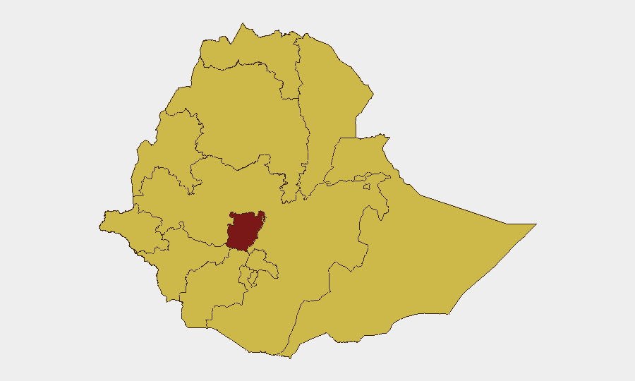
Situation Summary
Ethiopia remains at acute civil-conflict risk (#6 globally, composite threat score 100), with Central Ethiopia Regional State now the dominant flashpoint (risk 100) and 11 additional regions assessed at elevated threat (risk 70 each). Recent signals include government statements, international diplomatic tensions (including reduced relations and property seizure involving US interests as of 2026-06-30), and unconfirmed abduction reports affecting third-country nationals. The security environment remains fragmented and volatile, with wildfire activity adding secondary humanitarian and displacement pressure across central and border zones.
Key Developments
- 2026-06-30 · Diplomatic Escalation (Location: National) — Ethiopian government announced reduced relations; simultaneous property seizure actions targeting US interests reported. Implications for expatriate duty-of-care protocols and supply-chain continuity warrant immediate review.
- 2026-06-28 · Third-Country National Security Incident (Location: Not yet geographically specified) — Abduction/hijacking event involving Nigerian national(s) reported. Suggests criminal or armed-group activity beyond state control; geographic scope and hostage status require urgent clarification.
- 2026-06-30 · Property Seizure (Location: National, US-linked assets) — Multiple reports of Ethiopian authorities seizing or damaging US-linked property. Direct implications for foreign corporate and NGO asset security.
- 2026-06-28 · Regional Actor Statement (Eritrea/Asmara) — Public statement from Asmara; context suggests potential cross-border dimension to current tensions. Relevant to Tigray, Afar, and northern supply corridors.
- 2026-06-27 · Administrative Statement (Location: Not specified) — Government public statement; content and intent not yet verified. Monitor for policy or security posture changes affecting operations.
- Environmental Pressure (Location: Central/Sudan border zones, recent) — Multiple wildfires in Ethiopia and Sudan border region active; secondary risk of population displacement, resource stress, and armed-group recruitment in affected areas.
*Note: Open-source verification of granular incident locations and casualty counts remains incomplete for events <48 hours old.*
Highest-Risk Areas
Central Ethiopia Regional State (risk 100) is now the primary driver of national-level threat and should be the focus of all movement, personnel, and asset-security planning. Tigray, Amhara, Afar, Benishangul-Gumuz, and Somali regions remain at sustained risk (70 each), reflecting ongoing armed-group activity, communal conflict, and administrative fragmentation. Addis Ababa and Oromia, despite composite scores of 70, retain operational significance due to concentration of foreign personnel, international organizations, and government infrastructure; localized incidents (crime, protest, sectarian tension) can escalate rapidly. Risk concentration in the northern and eastern periphery, coupled with Central Ethiopia's escalation, suggests the conflict's geographic footprint remains broad and unpredictable.
How GeoBit Would Assist
Security teams should deploy AOI Monitoring & Early Warning focused on Central Ethiopia, Addis Ababa, and key border crossings to detect force movements, roadblock activity, and supply-chain disruption in real time. Intel Sweep and OSINT fusion (X/Twitter, Telegram, local media, radio SIGINT) will clarify the scope and actors behind the recent US-asset seizure and abduction incident, enabling rapid duty-of-care response. Conflict & Military battle mapping combined with Routing & Network Analysis supports alternative-route planning and safe-corridor identification for personnel and cargo movement.
7-Day Outlook
Escalatory signals (diplomatic tension, asset seizure, third-country abductions) suggest heightened state-to-international friction and possible armed-group activity in or near urban centers. Movement and supply-chain delays should be anticipated across Central Ethiopia and transit zones. Monitor Addis Ababa and northern corridors closely for announcements of travel restrictions, curfews, or further enforcement actions within 72 hours.
Highest-Risk Areas — Ranked
| # | State / Region | Risk |
|---|---|---|
| 1 | Central Ethiopia Regional State | 100 |
| 2 | Tigray | 70 |
| 3 | Amhara Region | 70 |
| 4 | Afar Region | 70 |
| 5 | Benishangul-Gumuz Region | 70 |
| 6 | Somali Region | 70 |
| 7 | Gambela Region | 70 |
| 8 | South West Ethiopia Peoples | 70 |
| 9 | Addis Ababa | 70 |
| 10 | South Ethiopia Regional State | 70 |
| 11 | Oromia Region | 70 |
| 12 | Sidama | 70 |
Sources
Previous Daily Briefs
A new Ethiopia brief is written every day — each with its own risk map and downloadable CSV. Here's the last week; use the calendar to go further back.
📅 Browse every day by calendar →
Highlighted days have a brief. Tap a day for that day's map & analysis, or “csv” for that day's dataset ($5).