Situation Summary
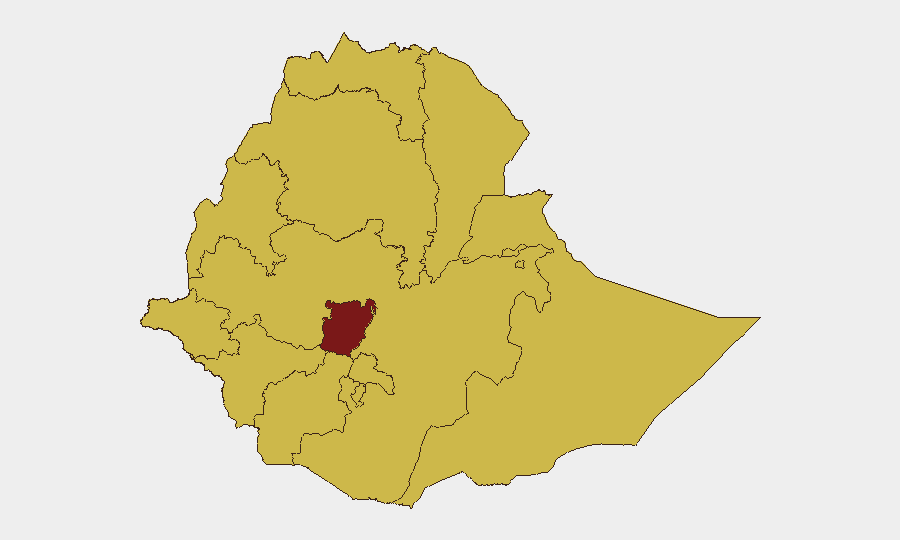
Ethiopia remains at elevated civil conflict risk (global rank #10, composite score 100), driven by ongoing armed clashes across multiple regions and deteriorating state-to-federal relations. Central Ethiopia Regional State carries the highest sub-national risk score (100), with Tigray, Amhara, Afar, and Benishangul-Gumuz all rated at 70. Event signals from June 30–July 1 indicate escalating rhetoric between state and federal actors, international diplomatic friction, and reported military engagements, though a coherent operational picture for the last 48 hours remains incomplete pending additional verified reporting.
Key Developments
GeoBit's live web research (last 24–48 hours) has identified event signals but cannot yet attribute these to specific, timestamped incidents at defined locations within June 30–July 2, 2026. The following signals are flagged:
- Diplomatic friction (June 30–July 1): Public statements and relation-reduction events involving Ethiopia, the United States, and New Zealand suggest international tension over policy or conduct, though specific triggers are not yet clarified in available sources.
- Security force tensions (June 30–July 1): Police and Ethiopian government actors issued public statements and faced public demonstrations, indicating possible domestic unrest or labor/governance friction.
- Alleged military engagement (June 30–July 1): An event signal references conventional military force between Ethiopian and Malawi actors; verification and operational context are pending.
- Property seizure (June 30): Two separate events indicate seizure or damage to U.S. property by Ethiopian actors, suggesting possible anti-American protest or asset targeting.
- Ongoing Amhara fighting (late June): Unverified reporting suggests military claims of neutralizing Fano fighters in Gojjam (Amhara Region), consistent with long-running insurgent activity in the region.
Note: Specific incident locations, casualty counts, and exact dates require corroboration from Ethiopian media (Addis Standard, Fana Broadcasting) and international newswires (Reuters, AFP, BBC Amharic) to meet verification standards.
Highest-Risk Areas
Central Ethiopia Regional State (risk 100) is the primary driver of national risk, reflecting the concentration of federal military and administrative targets and competing armed factions. Amhara Region (risk 70) remains volatile due to ongoing Fano insurgent activity and federal counter-operations; Tigray (risk 70) carries residual conflict risk and humanitarian exposure despite ceasefire agreements. Afar, Benishangul-Gumuz, Gambela, and Somali regions (all risk 70) are exposed to cross-border militia activity, pastoralist violence, and trafficking networks. Addis Ababa (risk 70), despite capital status, faces protest dynamics and security force operations tied to broader federal tensions. Organizations with personnel or assets in Amhara, central regions, and border areas face the highest operational risk.
How GeoBit Would Assist
Security teams would prioritize AOI Monitoring & Early Warning on high-risk regions (Amhara, Central Ethiopia, Afar) to detect military movement, protest staging, and checkpoint establishment in real time. Intel Sweep (global event feeds, multi-language OSINT, X/Twitter monitoring) would disambiguate the June 30–July 1 signals and identify emerging federal–state friction or anti-foreign sentiment. Battle Mapping and Force Structure tracking would clarify allegiances, unit dispositions, and likely escalation vectors; Routing & Network Analysis would enable safer movement corridors for personnel or convoys.
7-Day Outlook
Federal–state relations and international diplomatic messaging appear strained as of early July 2026; military signaling and protest activity may intensify if diplomatic channels do not stabilize. Amhara and Central Ethiopia regions will likely remain flashpoints for armed clashes and displacement. Organizations should monitor official U.S. and international travel advisories, maintain communication with local security liaisons, and prepare contingency evacuation or safe-area protocols.
Highest-Risk Areas — Ranked
| # | State / Region | Risk |
|---|---|---|
| 1 | Central Ethiopia Regional State | 100 |
| 2 | Tigray | 70 |
| 3 | Amhara Region | 70 |
| 4 | Afar Region | 70 |
| 5 | Benishangul-Gumuz Region | 70 |
| 6 | Somali Region | 70 |
| 7 | Gambela Region | 70 |
| 8 | South West Ethiopia Peoples | 70 |
| 9 | Addis Ababa | 70 |
| 10 | South Ethiopia Regional State | 70 |
| 11 | Oromia Region | 70 |
| 12 | Sidama | 70 |
Sources
Previous Daily Briefs
A new Ethiopia brief is written every day — each with its own risk map and downloadable CSV. Here's the last week; use the calendar to go further back.
📅 Browse every day by calendar →
Highlighted days have a brief. Tap a day for that day's map & analysis, or “csv” for that day's dataset ($5).