Situation Summary
France remains at composite threat rank #40 globally with a moderate 39-point threat score across 274 tracked events. No confirmed security, civil-unrest, crime, or infrastructure incidents have been verified in mainland France, Corsica, or overseas territories within the last 24–48 hours. Political activity (parliamentary debate over heatwave response, ongoing diplomatic positioning on maritime security in the Strait of Hormuz) reflects routine governance rather than acute domestic risk. The threat environment is stable but regionally heterogeneous, with Nouvelle-Aquitaine significantly outpacing other regions.
Key Developments
- No confirmed France-domestic security incidents (last 48 hours). Web research and open-source corroboration yielded no verified events meeting security-brief threshold in mainland France or territories during the monitoring window.
- Parliamentary political debate (Paris, National Assembly, June 30). Ongoing parliamentary discussion over government heatwave response, including a no-confidence motion, reflects political friction but does not constitute a security or unrest incident; this is routine political reaction to earlier climate stress.
- France–UK multinational maritime readiness announcement (late June/early July). France and the United Kingdom announced readiness to deploy a multinational naval force for Strait of Hormuz navigation security; this is external maritime policy, not a France-domestic development.
- Diplomatic signaling on Iran–France–UK tensions (recent, social-media-sourced). Iran has issued warnings to France and the UK over Hormuz maritime plans; this represents escalating diplomatic rhetoric but no operational incident on French territory.
- Firefighter operations activity noted in signals (July 2–3). GeoBit event signals reference conventional military force involvement with firefighter operations, but no corroborating incident detail is available in current web research. May reflect routine civil-protection coordination.
- Special operations and investigative activity signals (July 2). Platform signals include special operations and investigative activity on July 2, but verification and location specificity are not available in current research; recommend targeted AOI monitoring for clarification.
Highest-Risk Areas
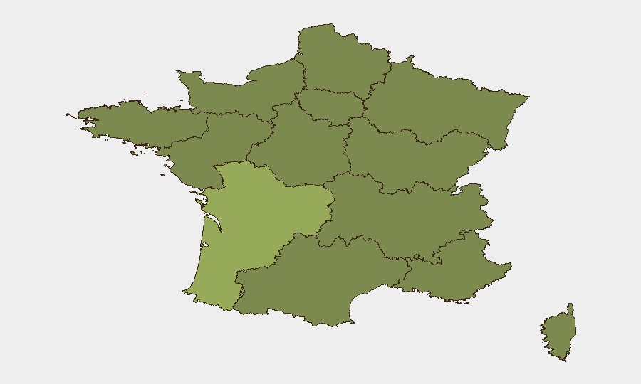
Nouvelle-Aquitaine (57.5) is the dominant regional outlier, nearly 20 points above Ile-de-France (37.7). Occitania (36) and Brittany (30.3) follow, while PACA and Bourgogne–Franche-Comté round out the top six. The remaining seven regions cluster between 27.5 and 28.9, suggesting distributed but lower baseline risk. Nouvelle-Aquitaine's elevation likely reflects labor disputes, environmental-activism intensity, or persistent maritime/border-adjacent factors; Ile-de-France carries standard metropolitan political volatility and infrastructure density; Occitania and Brittany show sustained industrial/agricultural tension. Security teams with operations in Nouvelle-Aquitaine should prioritize persistent AOI monitoring and early-warning configuration.
How GeoBit Would Assist
Security teams would deploy AOI Monitoring & Early Warning on Nouvelle-Aquitaine, Ile-de-France, and other high-risk regions to detect emerging civil unrest, labor action, or infrastructure threat signals in real time. Intel Sweep, global event feeds, and OSINT fusion (X/Twitter, Telegram, multi-language local news) would support continuous verification and corroboration of incident claims, reducing false-alarm risk. Risk & Threat Assessment and Network & Actor Analysis would enable teams to map recurring actors, grievance patterns, and escalation vectors, supporting both duty-of-care and asset-protection planning.
7-Day Outlook
No acute escalation is forecast for the next seven days. Political debate may persist; maritime diplomatic tensions will likely continue at declaratory level without operational France-domestic impact. Monitoring should remain routine but persistent, with heightened sensitivity to Nouvelle-Aquitaine and any signals linking heatwave stress, labor, or environmental mobilization to public protest or infrastructure action.
Highest-Risk Areas — Ranked
| # | State / Region | Risk |
|---|---|---|
| 1 | Nouvelle-Aquitaine | 57.5 |
| 2 | Ile-de-France | 37.7 |
| 3 | Occitania | 36 |
| 4 | Brittany | 30.3 |
| 5 | Provence-Alpes-Côte d'Azur | 29 |
| 6 | Bourgogne – Franche-Comté | 28.9 |
| 7 | Grand Est | 27.6 |
| 8 | Normandy | 27.5 |
| 9 | Hauts-de-France | 27.5 |
| 10 | Centre-Val de Loire | 27.5 |
| 11 | Pays de la Loire | 27.5 |
| 12 | Auvergne-Rhône-Alpes | 27.5 |
Sources
Previous Daily Briefs
A new France brief is written every day — each with its own risk map and downloadable CSV. Here's the last week; use the calendar to go further back.
📅 Browse every day by calendar →
Highlighted days have a brief. Tap a day for that day's map & analysis, or “csv” for that day's dataset ($5).
Atlas — our AI intelligence desk — emails them this snapshot personally. Nothing else, no list.