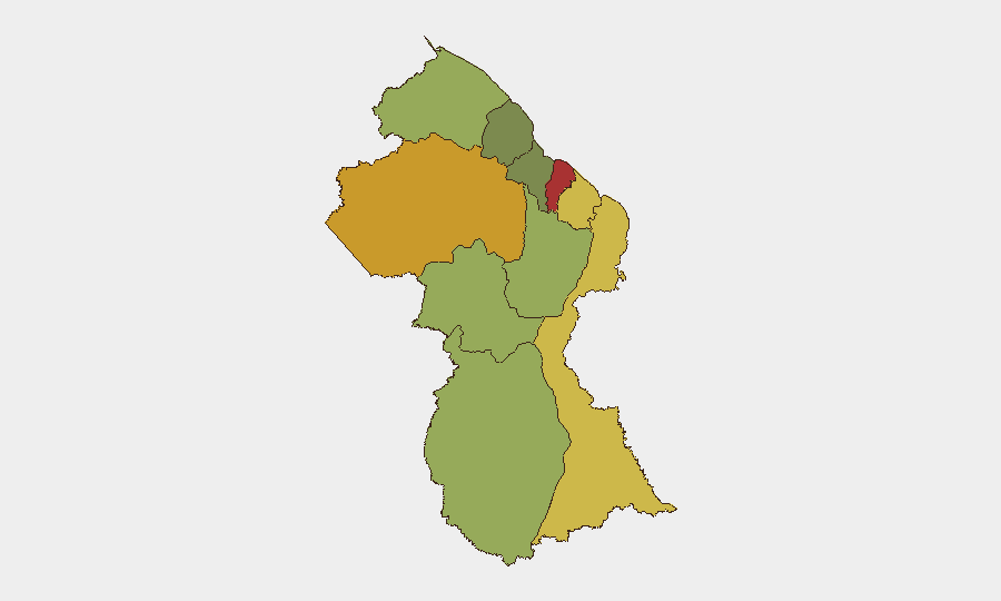
Situation Summary
Guyana remains a low-to-moderate threat environment globally (rank #94, composite score 14), but security volatility is concentrated in the coastal urban belt and interior mining zones. The past 48 hours have recorded multiple serious violent incidents—including a double homicide in Georgetown, an armed robbery attempt in East Bank Demerara, and ongoing civil unrest linked to the MV Barima maritime disaster—alongside weapons recovery and police-community friction. The risk profile is heavily skewed toward Demerara-Mahaica (risk 78) and Cuyuni-Mazaruni (risk 72), where gang-related crime, armed robbery, and trafficking pressures intersect with weak institutional capacity and limited police presence in remote areas.
Key Developments
- Georgetown, Water Street (2026-08-08): Police investigated a double stabbing fatality near Bounty Supermarket; suspect cited self-defense. Two males confirmed dead; motive and suspect status remain unclear.
- Providence, East Bank Demerara (2026-08-09): Three men allegedly attempted armed robbery of a residential property; armed resident confronted suspects, triggering gunfire. Suspects fled; no reported casualties or arrests at time of reporting.
- Cummings Park, Ogle airport zone (2026-08-08): Authorities issued a 10-day eviction notice to remaining squatters in the Eugene F. Correia International Airport clearance zone, signaling potential for civil disorder if compliance is resisted.
- Melanie Damishana / Model Village (2026-08-08): Residents clashed with police during a government consultation; two members of parliament were confronted. Reflects ongoing tension over regional resource distribution and service delivery.
- Region 10 / Linden (2026-08-05): Protest activity escalated during a government outreach visit, with demonstrators raising grievances linked to the MV Barima tragedy and unresolved hinterland development issues.
- Essequibo coastal waters (2026-08-08): Search-and-recovery operations for the MV Barima vessel continued; two additional bodies recovered, raising death toll. Operations ongoing; likelihood of further public unrest as casualty figures rise.
- Georgetown detention (2026-08-08): Two individuals arrested during MV Barima demonstrations filed complaints alleging unlawful arrest and police rights violations, adding to police-community friction.
- C Field, Sophia, Greater Georgetown (2026-08-05): Police recovered one AK-pattern assault rifle and two magazines from a dry drain during a search operation; no arrests reported to date.
Highest-Risk Areas
Demerara-Mahaica and Cuyuni-Mazaruni together account for the most acute threats, driven by gang presence, armed-robbery networks, and mineral-extraction violence. Mahaica-Berbice and East Berbice-Corentyne follow, reflecting spillover effects from coastal gang activity and inland diamond-mining disputes. The interior regions (Upper Demerara-Berbice, Potaro-Siparuni) pose secondary but significant risk due to remote geography, limited law-enforcement reach, and trafficking corridors; personnel in these zones face acute kidnap, robbery, and supply-chain disruption hazards.
How GeoBit Would Assist
Teams with personnel or assets in Guyana should employ AOI Monitoring & Early Warning on Demerara-Mahaica, Cuyuni-Mazaruni, and airport/port infrastructure zones to detect emerging gang, robbery, or protest activity in near-real time. Intel Sweep and X/Telegram OSINT enable tracking of gang communications, weapon movements, and community friction before incidents escalate. Routing & Network Analysis supports safer travel planning for staff in high-risk coastal and interior corridors, avoiding known robbery and kidnap hotspots.
7-Day Outlook
Armed robberies and gang-related violence are likely to persist at current levels; the airport eviction order (10-day window) poses moderate risk of civil disorder if resistance occurs. The MV Barima recovery operation will continue, sustaining public attention and potential for further protest activity in Linden and Georgetown. No imminent large-scale instability is forecast, but personnel should anticipate sporadic violent crime and brief localized unrest in coastal urban areas.
Highest-Risk Areas — Ranked
| # | State / Region | Risk |
|---|---|---|
| 1 | Demerara-Mahaica | 78 |
| 2 | Cuyuni-Mazaruni | 72 |
| 3 | Mahaica-Berbice | 65 |
| 4 | East Berbice-Corentyne | 62 |
| 5 | Upper Demerara-Berbice | 58 |
| 6 | Potaro-Siparuni | 48 |
| 7 | Barima-Waini | 45 |
| 8 | Upper Takutu-Upper Essequibo | 42 |
| 9 | Pomeroon-Supenaam | 38 |
| 10 | Essequibo Islands | 35 |
Sources
Previous Daily Briefs
A new Guyana brief is written every day — each with its own risk map and downloadable CSV. Here's the last week; use the calendar to go further back.
📅 Browse every day by calendar →
Highlighted days have a brief. Tap a day for that day's map & analysis, or “csv” for that day's dataset ($5).
Atlas — our AI intelligence desk — emails them this snapshot personally. Nothing else, no list.