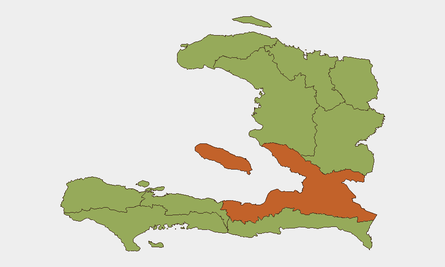
Situation Summary
Haiti remains in acute crisis, ranked #31 globally with gang-driven violence as the primary threat driver. Armed groups continue territorial control and resistance operations in Port-au-Prince and the coastal corridor, while the UN-backed Gang Suppression Force and Haitian National Police maintain counter-operations that generate significant collateral risk. Infrastructure disruption—notably fiber-optic cuts affecting southern departments—compounds operational and communications challenges. The security posture is volatile and unlikely to stabilize in the near term.
Key Developments
- Port-au-Prince, Martin Luther King Avenue (Route de Nazon) – 19 July 2026
U.S. Embassy issued a security alert warning of a sharp spike in targeted kidnapping risk over the following days in and around the MLK Avenue corridor, advising avoidance of the area and indicating active kidnap networks operating in central Port-au-Prince.
- Port-au-Prince and strategic transport corridors – through mid-July 2026
UN reporting confirms that GSF and HNP operations have pushed gangs out of some strategic areas including parts of Plaine du Cul-de-Sac and key transport routes; however, armed resistance remains high, sustaining crossfire and movement risks across affected corridors.
- Saint-Marc, Artibonite Department – 12–15 July 2026
IOM's Emergency Tracking Tool documented new displacement of residents following armed violence; households fled affected neighborhoods, adding to internal displacement burden in Artibonite and signaling heightened risk along the Saint-Marc–Port-au-Prince coastal corridor.
- National Road #2, southern Haiti – mid-July 2026
Digicel confirmed a major fiber-optic cable cut along RN2 in the deep south, causing significant internet degradation across affected departments and multi-day communications disruption; repair status remains unclear.
- Nord Department (Cap-Haïtien and wider region) – operations through 16 July 2026
Haitian National Police reported sustained counter-crime operations since early June yielding 391 arrests, 8 firearms seized, and multiple suspects neutralized in armed confrontations; ongoing police activity elevates crossfire and detention-related risks in northern communes.
Highest-Risk Areas
De l'Ouest Department (composite risk 73.8) dominates the national risk profile, substantially outpacing all other regions and reflecting concentrated gang territorial control and violence intensity in and around Port-au-Prince. Artibonite Department (44.2) ranks second due to armed clashes, displacement, and the strategic importance of the Saint-Marc–Port-au-Prince corridor; remaining departments cluster at 43.8, indicating more homogeneous underlying risk from distributed gang activity, police operations, and infrastructure vulnerability. Risk concentration in the western and northwestern zones reflects both population density and established gang strongholds.
How GeoBit Would Assist
Security teams would deploy AOI Monitoring & Early Warning on high-risk neighborhoods in Port-au-Prince (especially MLK Avenue, Plaine du Cul-de-Sac) and Saint-Marc to generate real-time alerts on violence spikes, displacement, or activity changes. Routing & Network Analysis would identify safe and high-risk movement corridors along RN2 and coastal routes, accounting for gang territorial control and infrastructure cuts. Intel Sweep and OSINT fusion across X/Telegram, YouTube, local radio SIGINT, and multi-language sources would provide early warning of kidnap campaigns, police operations, and gang movements, enabling duty-of-care decisions on personnel movement and asset security.
7-Day Outlook
Gang-suppression operations are likely to continue, maintaining elevated crossfire and kidnap risk in Port-au-Prince and Artibonite. Displacement flows are expected to persist as armed clashes remain unresolved. Communications degradation from infrastructure cuts will compound situational awareness challenges for operators in southern departments.
Highest-Risk Areas — Ranked
| # | State / Region | Risk |
|---|---|---|
| 1 | de l'Ouest Department | 73.8 |
| 2 | Artibonite Department | 44.2 |
| 3 | Grande-Anse Department | 43.8 |
| 4 | Sud Department | 43.8 |
| 5 | Nippes Department | 43.8 |
| 6 | Nord-Ouest Department | 43.8 |
| 7 | Nord Department | 43.8 |
| 8 | Nord-Est Department | 43.8 |
| 9 | Centre Department | 43.8 |
| 10 | Sud-Est Department | 43.8 |
Sources
Previous Daily Briefs
A new Haiti brief is written every day — each with its own risk map and downloadable CSV. Here's the last week; use the calendar to go further back.
📅 Browse every day by calendar →
Highlighted days have a brief. Tap a day for that day's map & analysis, or “csv” for that day's dataset ($5).
Atlas — our AI intelligence desk — emails them this snapshot personally. Nothing else, no list.