Situation Summary
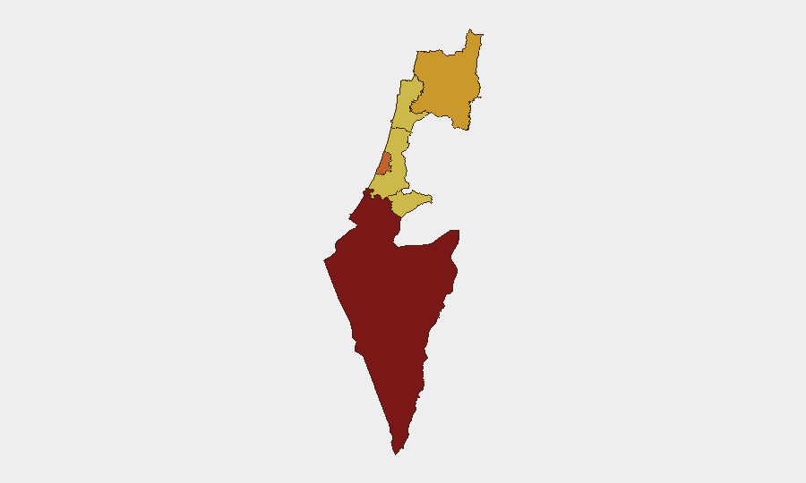
Israel faces a composite threat level ranked #6 globally as of 26 June 2026, driven by active military operations on multiple fronts, civil unrest linked to domestic political divisions, and cyber targeting of critical infrastructure. The security environment is characterized by ongoing cross-border military exchanges with Lebanon and Iran, large-scale Haredi protests disrupting internal movement, and extended diplomatic negotiations over force withdrawal from southern Lebanon—all of which elevate risk across multiple districts and sectors. The South District remains the highest-risk region (score 100), followed by Tel-Aviv, North, Haifa, and Center districts, reflecting concentrated threats in border areas and major urban centers.
Key Developments
- Nationwide Haredi protests blocking major roads – multiple Israeli cities – 25 June 2026
Large coordinated ultra-Orthodox demonstrations disrupted traffic across Israel, with reported blockages on Bar Ilan Street in Jerusalem and other major arteries. Police and Border Police deployed to clear intersections; scuffles between protesters and authorities were documented, creating short-term travel delays and elevated civil-unrest risk.
- Bar Ilan Street (Jerusalem) protest and police operations – 25 June 2026
Jerusalem District authorities deployed to clear road blockages during Haredi protest action, with temporary closure of a major traffic artery affecting local mobility and security conditions in the capital.
- Continued Israeli military strikes into southern Lebanon – northern border area – 25–26 June 2026
Israel maintained air and conventional strikes into southern Lebanon while ruling out an imminent withdrawal of IDF forces from occupied border zones. This posture reflects heightened military alert and operational tempo along the northern frontier with implications for cross-border movement and security in Israel's North District.
- Hezbollah civilian casualty claim from Israeli drone strike – southern Lebanon/Israel border theatre – 25 June 2026
Hezbollah alleged that an Israeli drone strike killed three civilians in southern Lebanon, claiming a ceasefire violation. Though casualties occurred outside Israel, the incident signals continued armed exchanges on the Israel–Lebanon front affecting alert posture and movement restrictions on the Israeli side.
- Iran-linked cyber operations targeting Israel's emergency alert infrastructure – nationwide – 26 June 2026
Security reporting documented attempts by Iran-linked actors to disrupt Israel's emergency alert and civil-protection systems, aimed at degrading infrastructure resilience and public-safety communication.
- Israel–Lebanon withdrawal negotiations extended without agreement – Israel–Lebanon border / political sphere – 26 June 2026
Talks on IDF withdrawal from southern Lebanon were extended by one additional day with gaps remaining unresolved. The continued uncertainty prolongs heightened military posture in border communities and reflects ongoing instability in Israel's northern security environment.
Highest-Risk Areas
The South District (risk score 100) and Tel-Aviv District (73.1) are the primary drivers of national-level threat, reflecting sustained exposure to rocket fire, militant activity, and humanitarian instability in the Gaza-adjacent South, as well as urban-center density and infrastructure concentration in Tel-Aviv. The North District (71.1), Haifa (70.1), and Center (70.1) face elevated risk from cross-border military operations and spillover from the Lebanon conflict, combined with domestic civil unrest. Jerusalem District (70), while lower-ranked, remains a focal point for protest activity and political sensitivity.
How GeoBit Would Assist
Security teams monitoring Israel should employ AOI Monitoring & Early Warning to track alert sirens, checkpoints, and movement restrictions in real time across the South and North districts. Intel Sweep and multi-language OSINT capabilities (X/Twitter, Telegram, news feeds) enable continuous detection of emerging protests, ceasefire violations, and cyber incidents 24–48 hours before escalation. Routing & Network Analysis tools help corporate and duty-of-care teams identify alternative transport corridors bypassing blocked roads, blocked ports, or militarized zones during unrest or active operations.
7-Day Outlook
Expect continued military operations along the Lebanon border with potential for expanded strikes if withdrawal talks collapse, sustained Haredi protest activity and road disruptions, and intensified cyber probing of Israeli infrastructure. The South District will likely remain the highest-risk zone; monitor the North District closely for spillover from cross-border military activity and any escalation in ceasefire violations.
Highest-Risk Areas — Ranked
| # | State / Region | Risk |
|---|---|---|
| 1 | South District | 100 |
| 2 | Tel-Aviv District | 73.1 |
| 3 | North District | 71.1 |
| 4 | Haifa District | 70.1 |
| 5 | Center District | 70.1 |
| 6 | Jerusalem District | 70 |
Sources
Previous Daily Briefs
A new Israel brief is written every day — each with its own risk map and downloadable CSV. Here's the last week; use the calendar to go further back.
📅 Browse every day by calendar →
Highlighted days have a brief. Tap a day for that day's map & analysis, or “csv” for that day's dataset ($5).