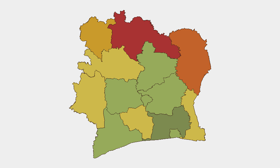
Situation Summary
Ivory Coast remains a composite threat rank #55 globally (score 30) with 11 tracked events, reflecting persistent low-to-moderate security risk concentrated in the northern border zones. The country's security posture is characterized by baseline criminality in urban centres and localized instability in remote districts rather than acute national-level crisis. Recent activity signals include government statements, company-level communications, and territorial occupation notices dated 17 July, though specifics remain limited in open reporting. The 24-hour security environment shows no major escalation beyond routine infrastructure incidents.
Key Developments
- PK 120, Autoroute du Nord (Yamoussoukro–Abidjan corridor) – 17 July 2026, night
A serious road traffic accident resulted in four fatalities and significant disruption on this critical national highway. Risk impact: temporary congestion, secondary accident risk, and potential delays for inter-city travel and logistics until clearing operations complete.
- Government and company public statements – 17 July 2026
Three distinct public communications issued (Government of Côte d'Ivoire vs. company; company statement; chief executive vs. company) alongside a government territorial occupation notice. Exact subject matter not detailed in available sources; warrants monitoring for labour, contractual, or regulatory dispute escalation.
- Abidjan civic disapproval signal – 17 July 2026
Abidjan authorities issued disapproval notice regarding multiple companies. Context unclear from available reporting; requires clarification to assess operational or reputational risk to corporate entities in-country.
- No acute security/conflict incidents reported – last 48 hours
Open-source monitoring shows no new armed clashes, civil unrest, major crime events, or infrastructure failures beyond the highway accident. Existing travel cautions (street crime, armed robbery risk in urban areas; sporadic banditry in northern regions) remain in place but unchanged.
Highest-Risk Areas
The northern savanna and border districts—Savanes (78), Zanzan (75), Denguélé (72), and Comoé (70)—drive the country's composite risk profile. These regions face persistent cross-border instability, remote terrain limiting state presence, and trafficking activity; risk scores reflect militia activity, banditry, and humanitarian exposure rather than acute conflict. Central mountainous areas (Montagnes, 68) and western zones (Woroba, 65; Sassandra-Marahoué, 58) represent secondary concern. By contrast, Abidjan (45) and southern coastal districts show significantly lower risk, though street crime and petty armed robbery remain routine concerns for residents and transiting personnel.
How GeoBit Would Assist
Security teams should deploy AOI Monitoring & Early Warning on the Savanes, Zanzan, and Denguélé districts to track cross-border movement, banditry indicators, and militia activity with real-time alerting. Routing & Network Analysis enables identification of safer inter-city corridors given the PK 120 highway disruption and northern instability; intelligence teams can model alternative supply and personnel routes. Intel Sweep, multi-language OSINT, and entity extraction on the 17 July government/company statements will clarify regulatory, labour, or contractual dimensions and assess reputational or operational exposure for corporate assets.
7-Day Outlook
No imminent escalation is forecast; risk trajectory remains stable at baseline northern instability and urban crime. Highway clearing operations should restore normal Yamoussoukro–Abidjan traffic within 48–72 hours. Duty-of-care teams should monitor resolution of the 17 July government–company communications and maintain standard northern-district travel restrictions and asset-protection protocols.
Highest-Risk Areas — Ranked
| # | State / Region | Risk |
|---|---|---|
| 1 | Savanes District | 78 |
| 2 | Zanzan District | 75 |
| 3 | Denguélé District | 72 |
| 4 | Comoé District | 70 |
| 5 | Montagnes District | 68 |
| 6 | Woroba District | 65 |
| 7 | Gôh-Djiboua District | 60 |
| 8 | Sassandra-Marahoué District | 58 |
| 9 | Vallée du Bandama District | 55 |
| 10 | Bas-Sassandra District | 52 |
| 11 | Lacs District | 48 |
| 12 | Abidjan | 45 |
Sources
Previous Daily Briefs
A new Ivory Coast brief is written every day — each with its own risk map and downloadable CSV. Here's the last week; use the calendar to go further back.
📅 Browse every day by calendar →
Highlighted days have a brief. Tap a day for that day's map & analysis, or “csv” for that day's dataset ($5).
Atlas — our AI intelligence desk — emails them this snapshot personally. Nothing else, no list.