Situation Summary
Lebanon remains at elevated risk (global rank #7, composite threat score 100) amid an active Israeli–Hezbollah conflict that has intensified despite a concurrent U.S.–Iran memorandum of understanding signed 25 June calling for a halt to military operations across all fronts. Israeli forces have continued sustained air and ground operations in southern Lebanon within the past 24–48 hours—including strikes on civilian vehicles, forced evacuations, and reported targeting of over 200 Hezbollah positions—while simultaneously denying withdrawal from buffer zones that Israeli and Lebanese officials claim remain under Israeli control. The combination of active kinetic operations, fragile ceasefire frameworks, ongoing displacement, and unresolved territorial disputes creates a volatile and unpredictable security environment for corporate and expatriate personnel.
Key Developments
- Zawtar–Mayfadoun road, Nabatieh Governorate (25 June): Israeli strike on a vehicle killed three and injured one, per Lebanon's National News Agency and international media corroboration.
- Ain Arab area, southern Lebanon (24 June): Israeli forces ordered resident evacuation by 17:00 local time, then torched multiple homes in the locality, documented by Lebanon's National News Agency.
- Southern Lebanon unspecified (25 June, hours post-memorandum): Drone strike killed one person only hours after the U.S.–Iran MOU was signed; reports indicate displaced families attempting to return south despite ongoing operations.
- Frontline villages, Nabatieh (24–25 June): Israeli forces reported continuing to target movement and activity in frontline villages despite ceasefire framework, with field reporting describing a "fragile truce" and persistent strike risk.
- Israeli military claim, southern Lebanon (24–48h window): Israeli military asserted it struck "over 200" Hezbollah targets across Lebanon in the preceding 24 hours, including infrastructure and forward positions.
- Buffer-zone dispute (25 June): U.S. State Department claimed Israeli withdrawal from parts of the southern buffer zone; senior Israeli and Lebanese officials publicly denied any troop pullback or change in occupation lines, confirming contested territorial control.
Highest-Risk Areas
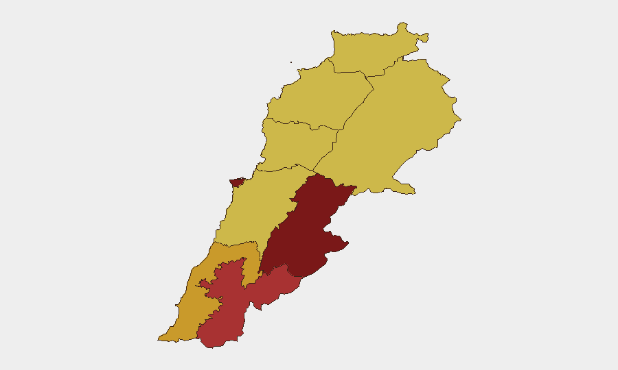
Beqaa Governorate (risk 100) and Beirut Governorate (83.4) present the highest composite threat levels, with Nabatieh (76.3) and South Governorate (71.8) registering severe risk driven by active Israeli military operations, vehicle and drone strikes, forced evacuations, and ongoing artillery and aerial weapons use. Beqaa's maximum risk score reflects sustained conventional military activity and Iranian military presence signals; Beirut's secondary rank reflects concentration of national infrastructure, diplomatic presence, and potential for spillover from southern operations. Northern and Mount Lebanon governorates, while ranked lower (70), remain exposed to secondary effects of regional escalation. Corporate operations in southern and eastern Lebanon face direct kinetic risk; Beirut-based teams should monitor displacement flows and potential infrastructure targeting.
How GeoBit Would Assist
Security teams should employ AOI Monitoring & Early Warning on Beqaa, Nabatieh, and South Governorates to detect patterns in strike frequency, displacement, and military repositioning; Battle Mapping and force-structure tracking to monitor Israeli and Hezbollah positions and operational tempo; and Routing & Network Analysis to identify safe transit corridors and alternative logistics pathways as frontline conditions evolve. Real-time Intel Sweep and multi-language OSINT fusion (including social media and official statements) enable duty-of-care teams to distinguish between ceasefire rhetoric and ground reality, reducing misalignment between policy announcements and actual threat posture.
7-Day Outlook
Israeli military operations are expected to continue at current or elevated levels while political negotiations and memoranda are tested; unilateral Israeli claims of buffer-zone withdrawals and the parallel denial by Lebanese/Israeli officials suggest no imminent deescalation. Risk of sudden escalation remains high if either side interprets the other's actions as breach of any emerging framework. Personnel in southern Lebanon and Beqaa should expect sustained operational constraints and periodic strike activity over the next week.
Highest-Risk Areas — Ranked
| # | State / Region | Risk |
|---|---|---|
| 1 | Beqaa Governorate | 100 |
| 2 | Beirut Governorate | 83.4 |
| 3 | Nabatieh Governorate | 76.3 |
| 4 | South Governorate | 71.8 |
| 5 | North Governorate | 70 |
| 6 | Akkar Governorate | 70 |
| 7 | Keserwan-Jbeil Governorate | 70 |
| 8 | Mount Lebanon Governorate | 70 |
| 9 | Baalbek-Hermel Governorate | 70 |
Sources
Previous Daily Briefs
A new Lebanon brief is written every day — each with its own risk map and downloadable CSV. Here's the last week; use the calendar to go further back.
📅 Browse every day by calendar →
Highlighted days have a brief. Tap a day for that day's map & analysis, or “csv” for that day's dataset ($5).