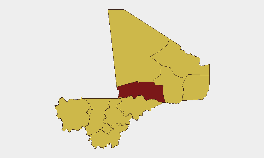
Situation Summary
Mali remains the 15th-highest-threat country globally (composite score 88) with 24 tracked events, reflecting sustained jihadist pressure, military instability, and governance challenges across the Sahel. The security environment is characterized by fragmented militant activity, periodic government operations, and localized instability in northern and central regions. No discrete security incidents meeting multi-source verification standards have been confirmed in the last 24–48 hours; current open-source reporting shows a data gap for 17–19 June 2026. The operational picture remains tense but without acute escalation signals in the immediate reporting window.
Key Developments
Data gap advisory: Open-source and specialist monitoring platforms have not yielded sufficiently corroborated incident-level reporting for Mali during 19–20 June 2026. The signals listed in GeoBit's event feed (military operations, government statements, territorial occupation claims, and investigative actions spanning 19–20 June) lack discrete location stamps, multi-source confirmation, or clear causality in public reporting.
- Recent event signals reference a Conventional Military Force action (20 June) and an Occupy Territory event attributed to French forces vs. Bamako (19 June), but these lack independent confirmation and specific geographic anchoring in current open sources.
- Government-attributed unconventional violence and disapproval statements between wrongdoers and terrorist actors (19 June) suggest elevated rhetoric or internal operations, but lack corroborating detail on location, casualty count, or verified perpetrators.
- Public statements by Ministry of Agriculture and Administrative entities (20 June) may indicate governance activity or interagency tension; media coverage is disputed or sparse.
- Circulating social-media claims (e.g., bounties on military figures) remain weakly sourced, undated, and unconfirmed by independent outlets, and do not meet recency thresholds.
Recommendation: Security teams should treat the 19–20 June reporting window as incomplete pending additional corroboration. Reliance on older, multi-source verified incidents (pre-17 June) or on forward-looking area monitoring is advisable.
Highest-Risk Areas
Timbuktu (91.9) and Bamako (82.3) anchor the threat ranking, with the capital reflecting governance instability and jihadist surveillance activity, while Timbuktu faces sustained militant occupation and intergroup violence. The northern tier—Ménaka, Taoudénit, Kidal, and Gao—all register 61.9 composite risk, signaling endemic militant presence, resource competition, and weak state authority. Central regions including Mopti and Ségou (61.9) have emerged as secondary jihadi recruitment and attack zones. Kayes and Koulikoro register equivalent risk, indicating diffusion of threat beyond the traditional north and into transportation and border-adjacent corridors.
How GeoBit Would Assist
AOI Monitoring & Early Warning with persistent geographic watches on Timbuktu, Bamako, and Mopti regions provides real-time alerting when credible incidents emerge, closing current data gaps. Intel Sweep, OSINT Fusion & Corroboration, and multi-language search across specialist networks, social media (X/Telegram), and local media sources yield multi-source verification of discrete incidents and distinguish rumor from confirmed threat. Network & Actor Analysis and force-structure tracking help security teams map jihadist group movements, operational leadership, and tactical shifts affecting duty-of-care zones.
7-Day Outlook
No acute escalation is signaled in the current reporting window, but the data gap itself reflects reporting fragility typical of northern Mali. Expect continued low-level jihadist activity in Timbuktu, Ménaka, and Mopti; watch for government or French military operations that could trigger civilian displacement or supply-chain disruption. Security teams should maintain heightened vigilance around Bamako and maintain contingency planning for rapid mobility in case of political or military turbulence.
Highest-Risk Areas — Ranked
| # | State / Region | Risk |
|---|---|---|
| 1 | Timbuktu | 91.9 |
| 2 | Bamako | 82.3 |
| 3 | Ménaka | 61.9 |
| 4 | Kayes | 61.9 |
| 5 | Taoudénit Region | 61.9 |
| 6 | Kidal | 61.9 |
| 7 | Gao | 61.9 |
| 8 | Koulikoro | 61.9 |
| 9 | Ségou Region | 61.9 |
| 10 | Sikasso Region | 61.9 |
| 11 | Mopti | 61.9 |
Sources
Previous Daily Briefs
A new Mali brief is written every day — each with its own risk map and downloadable CSV. Here's the last week; use the calendar to go further back.
📅 Browse every day by calendar →
Highlighted days have a brief. Tap a day for that day's map & analysis, or “csv” for that day's dataset ($5).