Situation Summary
Malta remains a low-threat environment globally (rank #166, composite score 5) with no active tracked security events and minimal civil unrest or organized violence in the reporting window. The last 24–48 hours have yielded isolated incidents—a serious maritime diving accident, routine court proceedings on older criminal cases, and political criticism of hospital capacity—none indicating systemic security deterioration or emerging mass-casualty risk. The sub-national risk ranking reflects elevated scores in urban centres (Valletta, Sliema, St Julian's) likely driven by density, tourism, and nightlife-area crime rather than organized conflict or terrorism.
Key Developments
- Comino / Mġarr Harbour, Gozo (22–24 August): A 51-year-old Italian diver was found unconscious during a recreational dive off Comino on 22 August, transported by boat to Mġarr Harbour and then by ambulance to Gozo General Hospital, where he remains in serious condition. A magistrate's inquiry and police investigation are underway to establish circumstances and safety compliance.
- Swieqi & Malta International Airport (20–24 August): Six Italian youths were arrested at the airport on 20–21 August following CCTV evidence linking them to car vandalism in Swieqi. By 22 August, two teenagers pleaded guilty to vandalizing four vehicles, received suspended sentences, and were referred for deportation; immigration proceedings remain active as of 24 August.
- Mater Dei Hospital, Msida (24 August): The Nationalist Party publicly stated that Mater Dei Hospital is experiencing a "worsening capacity crisis" beyond seasonal pressures, signalling political contention over health-system management but no associated civil unrest or public protests in the reporting window.
- St Julian's / Ta' Giorni (court update 22–24 August): Ongoing legal proceedings against John Agius, accused of shooting two police officers during a standoff in July and arson at a construction site, are continuing with evidence compilation; he faces attempted-murder and firearms charges and has pleaded not guilty. This reflects legal/procedural activity on an older incident, not fresh violence.
- General maritime & emergency response (22–24 August): The Comino diving emergency highlighted coordinated multi-agency response across Gozo–Comino maritime routes and ground ambulance services, with no reported failures or secondary incidents.
Highest-Risk Areas
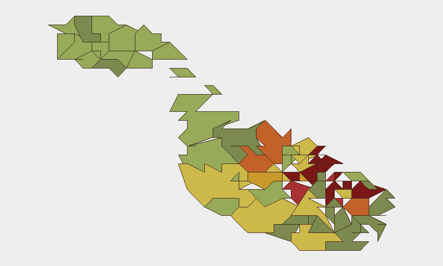
Valletta (95), Sliema (92), and St Julian's (90) dominate the sub-national ranking, reflecting their roles as commercial, tourist, and entertainment hubs with high foot traffic, nightlife-area property crime, and historical incidents such as the Ta' Giorni police shooting. Urban density and tourism influx drive exposure to opportunistic crime (vehicle vandalism, theft) and occasional serious violent crime, but no evidence of territorial organized crime, gang warfare, or terrorism. Peripheral and rural areas (Żabbar, Cospicua, Senglea) record lower scores, suggesting risk concentrates in economically active and tourist-dense zones.
How GeoBit Would Assist
Security teams operating in Malta would benefit from persistent AOI monitoring & early warning on high-risk urban centres (Valletta, Sliema, St Julian's) to detect emerging protest activity, crime spikes, or accident patterns; OSINT fusion (X/Twitter, Telegram, local news) to corroborate incident reports and distinguish genuine threats from noise; and maritime & aviation tracking to monitor regional ferry routes, diving-site traffic, and airport passenger flows for anomalies or secondary risks. Real-time multi-language web search and sentiment analysis would flag political and health-system narratives before they escalate to public unrest.
7-Day Outlook
No material escalation is anticipated over the next seven days. Court proceedings on existing cases will continue; the diving accident will remain under investigation with no forecast of wider implications. Political debate over hospital capacity may intensify but is unlikely to trigger organized demonstrations. Routine tourism, nightlife-area petty crime, and emergency response remain the primary risk vectors for corporate assets and personnel.
Highest-Risk Areas — Ranked
| # | State / Region | Risk |
|---|---|---|
| 1 | Valletta | 95 |
| 2 | Sliema | 92 |
| 3 | Saint Julian's | 90 |
| 4 | Gżira | 88 |
| 5 | Hamrun | 87 |
| 6 | Paola | 86 |
| 7 | Msida | 85 |
| 8 | Birkirkara | 84 |
| 9 | Birgu | 83 |
| 10 | Senglea | 82 |
| 11 | Cospicua | 81 |
| 12 | Żabbar | 80 |
Sources
Previous Daily Briefs
A new Malta brief is written every day — each with its own risk map and downloadable CSV. Here's the last week; use the calendar to go further back.
- August 22, 2026
- August 20, 2026
- August 18, 2026
- August 15, 2026
- August 13, 2026
- August 11, 2026
- August 9, 2026
📅 Browse every day by calendar →
Highlighted days have a brief. Tap a day for that day's map & analysis, or “csv” for that day's dataset ($5).
Atlas — our AI intelligence desk — emails them this snapshot personally. Nothing else, no list.