Situation Summary
Mauritania remains a low-frequency event environment globally (rank #143, composite score 7) with no tracked security incidents recorded in the 24–48 hour window. The country's threat profile is heavily concentrated in remote northern and eastern border regions, where counterterrorism operations and irregular migration pressures persist. Current humanitarian and maritime activity—notably a large migrant rescue operation on 2026-08-21—reflects chronic regional instability and transit vulnerabilities rather than acute escalation. Overall trajectory remains stable but fragmented by persistent sub-national risk concentration in Saharan territories.
Key Developments
- Atlantic waters, west of Mauritania — 2026-08-21 — Mauritanian coastguard rescued 315 migrants, including 40 children, from an overloaded, drifting vessel; rescue confirmed across multiple independent sources. Incident underscores sustained maritime-migration pressure and search-and-rescue burden on state resources.
- U.S. State Department advisory (Mauritania-wide) — 2026-08-21 to 2026-08-24 — Level 3 advisory remains in force, citing crime, terrorism, and limited health infrastructure as primary concerns; advisory is routine restatement, not new threat development.
- No new incident-level security events recorded in the past 24–48 hours across GeoBit's tracked event feeds, OSINT sweep, or live web research.
Highest-Risk Areas
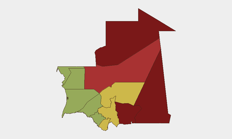
Tiris Zemmour (risk 95) and Hodh Ech Chargui (risk 85) dominate the sub-national threat profile, reflecting their proximity to ungoverned border zones and known militant transit corridors in the Sahara-Sahel belt. Hodh El Gharbi and Adrar follow at elevated but slightly lower risk, driven by similar cross-border and terrain-access factors. These four northern and eastern regions account for the majority of structural counterterrorism and smuggling-related risk; central and coastal regions (Brakna, Dakhlet Nouadhibou) show materially lower composite scores, though coastal areas remain vulnerable to maritime crime and irregular migration. Corporate assets and personnel in the capital region should maintain proportionate vigilance; those operating or transiting in remote mining or resource-extraction zones in Tiris Zemmour and the Hodh regions face elevated exposure to militant activity, banditry, and state-capacity gaps.
How GeoBit Would Assist
Security teams with personnel or assets in high-risk regions should deploy AOI (Area-of-Interest) Monitoring & Early Warning on Tiris Zemmour and Hodh Ech Chargui to receive persistent alerts on incident activity, militant movement, or armed clashes. Maritime & Aviation tracking and OSINT fusion (X/Twitter, Telegram, regional news sources) would provide early visibility into irregular migration surges and coastal security events that could disrupt logistics or evacuation routing. Routing & Network Analysis can map secure alternate supply-chain and personnel-movement corridors around confirmed high-risk zones, and Border & Disputed-Territory search capabilities help identify evolving cross-border transit vulnerabilities and militant sanctuary areas.
7-Day Outlook
No significant escalation is forecast for the coming week. Maritime-migration activity and routine sub-national security operations will likely continue at baseline levels. Risk remains geographically partitioned; incidents, if any, will cluster in northern and eastern border zones. Duty-of-care teams should maintain current alert postures and continue monitoring maritime and migration updates, particularly for any incidents that might affect supply-chain or personnel-evacuation access to coastal ports.
Highest-Risk Areas — Ranked
| # | State / Region | Risk |
|---|---|---|
| 1 | Tiris Zemmour | 95 |
| 2 | Hodh Ech Chargui | 85 |
| 3 | Hodh El Gharbi | 80 |
| 4 | Adrar | 78 |
| 5 | Tagant | 68 |
| 6 | Guidimaka | 65 |
| 7 | Assaba | 62 |
| 8 | Gorgol | 58 |
| 9 | Trarza | 55 |
| 10 | Inchiri | 52 |
| 11 | Brakna | 48 |
| 12 | Dakhlet Nouadhibou | 45 |
Sources
Previous Daily Briefs
A new Mauritania brief is written every day — each with its own risk map and downloadable CSV. Here's the last week; use the calendar to go further back.
- August 22, 2026
- August 20, 2026
- August 18, 2026
- August 16, 2026
- August 14, 2026
- August 12, 2026
- August 10, 2026
📅 Browse every day by calendar →
Highlighted days have a brief. Tap a day for that day's map & analysis, or “csv” for that day's dataset ($5).
Atlas — our AI intelligence desk — emails them this snapshot personally. Nothing else, no list.