Situation Summary
Moldova faces sustained airspace incursions and sovereignty violations linked to Russian drone and cruise-missile operations against Ukrainian targets, with at least three confirmed cross-border incidents in the past week. The transits pose no direct armed threat to Moldovan territory but create safety hazards, disrupt air traffic, and underscore Moldova's exposure to regional conflict spillover. Governance concerns—including the recent arrest of Gagauzia's regional head—add localized institutional risk. Overall threat level remains moderate but operationally active.
Key Developments
- Southern Moldova airspace incursion (24 Aug, ~05:55–06:09 UTC) – An unidentified drone entered Moldovan airspace from Vynohradivka (Odesa oblast, Ukraine), transited over southern Moldova toward Vulcănești in UTA Găgăuzia, and exited near Pașcani (Cahul district) toward Romania. The Ministry of Defence imposed a 15-minute airspace closure; the incident occurred during concurrent Russian aerial strikes on Ukraine and was treated as a sovereignty violation.
- Cross-border air monitoring and Romanian response (24 Aug, ~06:00 UTC) – Following the southern Moldova incursion, Romanian military radar detected intermittent signals in Moldovan airspace near Cahul, with one contact later appearing over Târgu Bujor (Galați County, Romania). Romania scrambled two F-16s and an IAR-330 SOCAT helicopter; authorities issued a public RO-Alert warning at 06:12, reflecting heightened regional airspace coordination.
- Tabachi border-crossing damage and closure (ongoing impact, 24 Aug) – Russian drone strikes on 20–21 Aug damaged the Tabaki/Tabachi international checkpoint on the Ukrainian side of the Moldova border, forcing suspension of passenger and vehicle traffic. Cross-border redirection remains in effect, affecting regional mobility and trade flow.
- Giurgiulești drone debris discovery (20 Aug, updates 24 Aug) – The Ministry of Internal Affairs confirmed multiple drone incidents near Giurgiulești in the Moldova–Ukraine–Romania border triangle, including discovery of Geran/Shahed-136 debris close to Moldovan territory, linked to Russian strikes on Reni (Ukraine) port infrastructure.
- Talmaza aerial intrusion and debris (17–18 Aug, Defence Minister reiteration 24 Aug) – An unidentified aerial object entered central Moldovan airspace between Cuciurgan and Tiraspol, triggering a 15-minute airspace closure and subsequently crashing near Talmaza village, causing a grass fire with no casualties. The Defence Minister restated on 24 Aug that hostile Russian activities against Ukraine also endanger Moldova's security.
- Chișinău traffic incident and official misconduct (evening 23 Aug) – A 26-year-old public official from the Durlești mayor's office crashed into a parked vehicle while severely intoxicated (1.15 mg/L exhaled alcohol). The vehicle was seized and the driver detained, with prior police documentation of alcohol abuse and hooligan behavior; low immediate security impact but reflects localized governance and law-and-order risks.
- Peace March commemorative event (24 Aug, daytime) – A Peace March marking the 82nd anniversary of Moldova's liberation from Nazism proceeded through central Chișinău without reported clashes or arrests, though the event carries political-symbolic significance in Moldova's contested civic memory landscape.
Highest-Risk Areas
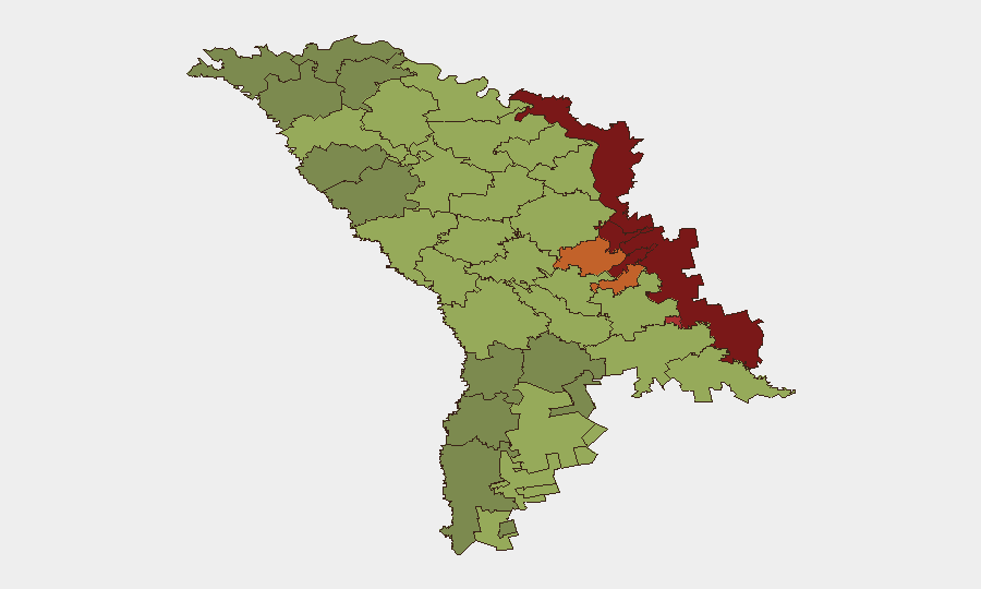
The Left Bank of the Dniester (risk 85), Dubăsari (82), and Bender (79) remain Moldova's highest-risk zones, reflecting persistent separatist institutional structures, Russian military presence, and limited state control. Southern border regions—Gagauzia (54), Taraclia (55), Căușeni (53), and Ștefan Vodă (51)—face concentrated drone-transit risk and cross-border spillover. Chișinău (49), while lower-ranked, remains a governance and political-symbolic focal point. The current airspace incidents predominantly affect southern and central Moldova; sustained monitoring of the Cahul–Vulcănești corridor and the Giurgiulești triangle is operationally critical.
How GeoBit Would Assist
A corporate security team in Moldova should deploy AOI Monitoring & Early Warning on southern airspace corridors and border checkpoints (Tabachi, Giurgiulești, Cahul) to receive real-time alerts on drone activity and traffic disruptions. Aviation tracking and Network & Actor Analysis (linking Russian drone patterns and targeting signatures) provide predictive context for future incursions. GIS & Spatial Analysis and Routing & Network Analysis enable alternative cross-border and internal travel planning during airspace closures.
7-Day Outlook
Russian drone operations against Ukrainian targets will likely continue, sustaining a 30–40% probability of additional airspace transits over southern Moldova within the next seven days. Border checkpoints may experience intermittent closures tied to Ukrainian-side damage and repair cycles. Domestic governance risks (official misconduct, regional political tension in Gagauzia) remain secondary but warrant monitoring of public order and institutional stability in low-risk periods.
Highest-Risk Areas — Ranked
| # | State / Region | Risk |
|---|---|---|
| 1 | Administrative-Territorial Units of the Left Bank of the Dniester | 85 |
| 2 | Dubăsari | 82 |
| 3 | Bender | 79 |
| 4 | Criuleni | 75 |
| 5 | Rezina | 58 |
| 6 | Taraclia | 55 |
| 7 | Gagauzia | 54 |
| 8 | Căușeni | 53 |
| 9 | Soroca | 52 |
| 10 | Ștefan Vodă | 51 |
| 11 | Orhei | 50 |
| 12 | Chișinău | 49 |
Sources
Previous Daily Briefs
A new Moldova brief is written every day — each with its own risk map and downloadable CSV. Here's the last week; use the calendar to go further back.
- August 22, 2026
- August 20, 2026
- August 18, 2026
- August 15, 2026
- August 13, 2026
- August 11, 2026
- August 9, 2026
📅 Browse every day by calendar →
Highlighted days have a brief. Tap a day for that day's map & analysis, or “csv” for that day's dataset ($5).
Atlas — our AI intelligence desk — emails them this snapshot personally. Nothing else, no list.