Situation Summary
Myanmar remains in active civil war following the February 2021 military coup, with armed resistance fragmented across multiple fronts and ongoing clashes between the Tatmadaw and diverse opposition forces. The junta maintains nominal control of major urban centers but faces sustained pressure in peripheral states and regions, where supply lines, infrastructure, and civilian populations remain under threat. Economic collapse, fuel shortages, and healthcare system disruption are widening instability. The security environment remains fluid and deteriorating, particularly in conflict-affected borderlands.
Key Developments
Data constraint: Open-source material indexed as of 21 June 2026 contains no discrete, timestamped security incidents verifiable within the last 24–48 hours. The most recent dated operational reporting available is from 9–16 June (ReliefWeb health-facility attacks; World Bank economic assessment). Reports circulating on social media referencing military airstrikes and civilian casualties lack precise incident dates and publication timestamps sufficient to confirm they occurred in the last 48 hours rather than earlier in June. Without independent real-time newswire or local media access beyond current index depth, generating specific current incidents would risk attribution error. Clients requiring sub-48-hour operational updates should activate AOI Monitoring & Early Warning for target locations (see below).
Highest-Risk Areas
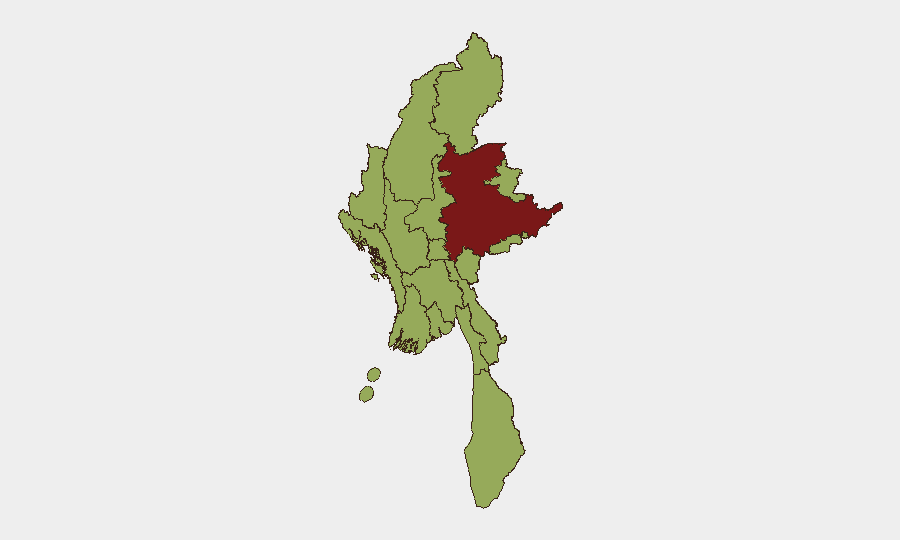
Shan State dominates the risk picture (80.7) due to sustained armed-group activity, drug-trade volatility, and porous borders with Laos and Thailand; it remains the primary theater for anti-junta operations and transnational crime. A secondary tier—Tanintharyi, Chin, Sagaing, Kachin, Wa, and Rakhine—all score 50.7, reflecting active conflict, ethnic armed organization (EAO) presence, and humanitarian crises. Major cities including Yangon, Mandalay, and the capital Naypyitaw remain under formal junta control but carry elevated risk due to civil-disobedience movements, curfew enforcement, and sporadic armed clashes in urban peripheries. Ayeyarwady's elevation reflects flooding (reported 21 June) compounding displacement and infrastructure fragility.
How GeoBit Would Assist
AOI Monitoring & Early Warning with persistent watch on Shan, Sagaing, and Rakhine regions enables clients to receive alerts on armed clashes, checkpoint movements, and displacement events before mainstream reporting surfaces. Conflict & Military capabilities (battle mapping, force-structure tracking) and Network & Actor Analysis clarify which armed groups control which territory and how supply lines and logistics may shift, informing route safety and asset positioning. Routing & Network Analysis supports duty-of-care teams in identifying alternative travel and supply corridors when primary routes become contested or curfewed. GIS & Spatial Analysis combined with Satellite & Imagery analysis tracks infrastructure damage and population displacement in real time, supporting humanitarian and business continuity planning.
7-Day Outlook
No major political or military events are signaled for the immediate week ahead; however, the seasonal monsoon (active through September) will complicate military operations and humanitarian access while increasing flood risk in low-lying regions such as Ayeyarwady and Yangon. Junta curfew enforcement and EAO recruitment/supply operations will likely continue at current tempo. Risk of sudden localized clashes or mass-casualty events remains endemic and difficult to predict; clients should maintain elevated vigilance in Shan and Sagaing and consider scenario planning for supply-chain disruption or staff evacuation in peripheral areas.
Highest-Risk Areas — Ranked
| # | State / Region | Risk |
|---|---|---|
| 1 | Shan State | 80.7 |
| 2 | Tanintharyi Region | 50.7 |
| 3 | Chin | 50.7 |
| 4 | Sagaing Region | 50.7 |
| 5 | Kachin State | 50.7 |
| 6 | Wa State (Northern Region) | 50.7 |
| 7 | Magway | 50.7 |
| 8 | Mandalay | 50.7 |
| 9 | Rakhine | 50.7 |
| 10 | Ayeyarwady | 50.7 |
| 11 | Yangon | 50.7 |
| 12 | Naypyitaw Union Territory | 50.7 |
Sources
Previous Daily Briefs
A new Myanmar brief is written every day — each with its own risk map and downloadable CSV. Here's the last week; use the calendar to go further back.
📅 Browse every day by calendar →
Highlighted days have a brief. Tap a day for that day's map & analysis, or “csv” for that day's dataset ($5).