Situation Summary
Niger remains under persistent terrorist threat and faces significant political instability following the 2023 coup, with security conditions deteriorating most acutely in the Sahel and Agadez mining regions. The country ranks #18 globally in GeoBit's composite threat assessment (score 97) and continues to face coordinated insurgent activity, kidnapping risk, and transnational militant operations. Recent reporting (as of 25 June 2026) reflects ongoing tension and volatility, though open-source confirmation of specific new incidents in the immediate 24–48 hour window remains limited.
Key Developments
Reporting Constraint: GeoBit's live web research (last 24–48 hours, Niger) has identified no clearly documented and independently verified new attacks, protests, or major security incidents that can be cross-confirmed across multiple time-stamped sources and attributed specifically to Niger in this narrow window.
Most current indexed coverage references either:
- The 18 June 2026 Niamey airport attack (now 7+ days old; outside the 24–48h window)
- Standing UK/international travel advisories (last substantively updated 28 May 2026)
- Undated or older social-media items lacking reliable time-stamps
- Events in Nigeria (a separate country), not Niger
Operational Note: If your security team requires an incident-focused brief, GeoBit recommends expanding the assessment window to 7–10 days (which would include the Niamey airport strike and follow-on security operations) or pivoting to a forward-looking risk assessment by sub-national region based on established threat patterns and early-warning indicators.
Highest-Risk Areas
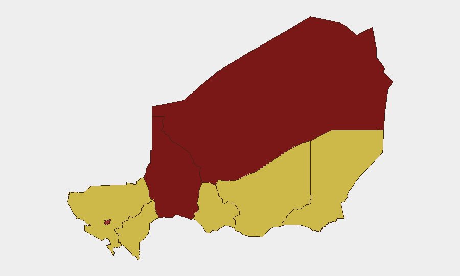
Agadez Region (risk score 98) and Tahoua Region (93.7) remain the primary drivers of Niger's elevated threat profile, reflecting active armed group presence, mining-sector vulnerabilities, and limited state control in remote border zones. Niamey (76.5) carries elevated risk due to past attack patterns and the concentration of government and international assets; Zinder, Diffa, Tillabéri, Dosso, and Maradi regions all remain at baseline elevated risk (68) due to cross-border militant activity and porous security perimeters. The gap between Agadez/Tahoua and other regions underscores the concentration of both militant capacity and state counter-terrorism operations in the north.
How GeoBit Would Assist
Security teams with personnel or assets in Niger should employ GeoBit's AOI Monitoring & Early Warning service to establish persistent watches over high-risk administrative zones (particularly Agadez and Tahoua) with automated alerting on new event signals. Intel Sweep and multi-language OSINT fusion across open feeds, social media, and local news sources enable rapid cross-confirmation of emerging incidents and reduce false-alarm risk. Alternative route and network analysis tools support contingency planning for personnel movement, while conflict & military force-tracking and battle mapping maintain situational awareness of armed-group positions and state counter-insurgency operations.
7-Day Outlook
Near-term risk trajectory in Niger remains stable at elevated baseline, with no indication of imminent major escalation; however, the sparse quality of current open-source reporting should not be interpreted as risk reduction. Persistent militant activity in the north, ongoing political tensions, and the fragile security environment post-coup suggest continued volatility and periodic localized incidents are highly probable. Security teams should assume heightened ambient risk persists and avoid confidence-building from the absence of 24–48h incident reporting.
Highest-Risk Areas — Ranked
| # | State / Region | Risk |
|---|---|---|
| 1 | Agadez Region | 98 |
| 2 | Tahoua Region | 93.7 |
| 3 | Niamey | 76.5 |
| 4 | Zinder Region | 68 |
| 5 | Diffa Region | 68 |
| 6 | Tillabéri Region | 68 |
| 7 | Dosso Region | 68 |
| 8 | Maradi Region | 68 |
Sources
Previous Daily Briefs
A new Niger brief is written every day — each with its own risk map and downloadable CSV. Here's the last week; use the calendar to go further back.
📅 Browse every day by calendar →
Highlighted days have a brief. Tap a day for that day's map & analysis, or “csv” for that day's dataset ($5).