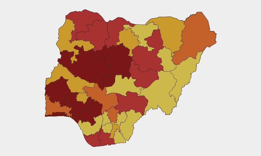
Situation Summary
Nigeria remains the second-highest-threat nation globally, with 1,105 tracked events and a composite threat score of 100. Over the last 48 hours, a cluster of high-lethality incidents—including a 20-person mass killing in Plateau State, a school abduction in Kebbi State, and a coordinated banking-sector threat—signals sustained operational capacity among armed groups and growing targeting of civilian and financial infrastructure. The federal government's declaration of a terror alert and deployment of additional security assets, alongside transmission of a State Police Bill to the Senate, reflects escalating security concerns and ongoing institutional responses.
Key Developments
- Bokkos LGA, Plateau State (June 22–24): Armed gunmen killed at least 20 civilians in a rural community attack; Plateau State police have confirmed fatalities and opened formal investigation. This incident represents one of the highest single-casualty events in recent reporting cycles.
- NIPSS campus, Kuru, Jos South LGA, Plateau State (June 22–24): A confirmed security incident at or near the National Institute for Policy and Strategic Studies prompted rapid response and containment operations by security agencies; formal investigation ongoing.
- Kebbi State girls' school (June 22–24): Armed bandits attacked a school, killing the vice principal and abducting approximately 24 schoolgirls; at least two girls subsequently escaped. The incident underscores persistent targeting of education facilities and vulnerable populations.
- FirstBank threat incident (June 24): A security alert flagged delivery of a threat message accompanied by live ammunition directed at FirstBank, circulated across social media and security monitoring platforms as a credible intimidation signal to Nigeria's financial sector.
- Federal security posture escalation (June 24): Federal Government declared holidays and deployed additional security assets nationwide amid a terror alert, raising short-term travel and operational risk in major urban centers.
- State Police Bill transmission (June 24): President Tinubu transmitted the State Police Bill to the National Assembly with Senate leadership pledging safeguards; viewed by civil-society monitors as a significant governance and internal-security development with long-term implications.
- Kaduna State forced relocation (June 22–24): Authorities announced large-scale resident displacement in Rigasa, Igabi LGA, due to gully erosion, with a ₦34 billion remediation project; flagged as secondary security and displacement risk.
Highest-Risk Areas
Oyo State (risk score 100) and Lagos State (95.3) dominate the sub-national ranking and reflect concentration of both armed-group activity and urban vulnerability. However, Plateau State (78.8) and Niger State (91.7) currently show the highest acute threat from mass-casualty incidents and coordinated attacks on civilians and strategic sites. Kaduna State (86.1) and Kebbi State (not separately ranked but recent school attack suggests elevated exposure) remain critical flashpoints for banditry, kidnapping, and infrastructure disruption. The geographic spread across middle-belt and northern states, combined with Federal Capital Territory inclusion (82.8), indicates diffuse rather than localized threat concentration.
How GeoBit Would Assist
A corporate security team operating in Nigeria would deploy AOI Monitoring & Early Warning to track Plateau, Kaduna, and Kebbi states in real time for incident escalation and secondary attack patterns. OSINT Fusion & Corroboration (X/Twitter, Telegram, news feeds, and civil-society reporting) enables rapid confirmation of emerging threats, as demonstrated by FirstBank warning detection. Routing & Network Analysis supports alternative travel planning in high-risk states, while GIS & Spatial Analysis refines facility-risk assessments around schools, financial institutions, and government sites.
7-Day Outlook
Immediate risk remains elevated across the middle belt and northern Nigeria, with school and infrastructure sites likely to remain high-value targets. The federal security alert and legislative activity around the State Police Bill may temporarily increase checkpoint activity and travel disruptions in major corridors. Absent significant operational disruption of armed groups, incident frequency is likely to sustain or incrementally increase over the next seven days.
Highest-Risk Areas — Ranked
| # | State / Region | Risk |
|---|---|---|
| 1 | Oyo State | 100 |
| 2 | Lagos State | 95.3 |
| 3 | Niger State | 91.7 |
| 4 | Kaduna State | 86.1 |
| 5 | Osun State | 86.1 |
| 6 | Federal Capital Territory | 82.8 |
| 7 | Ondo State | 82.1 |
| 8 | Edo State | 81.7 |
| 9 | Sokoto State | 79.8 |
| 10 | Plateau State | 78.8 |
| 11 | Rivers State | 78 |
| 12 | Bauchi State | 77.9 |
Sources
Previous Daily Briefs
A new Nigeria brief is written every day — each with its own risk map and downloadable CSV. Here's the last week; use the calendar to go further back.
📅 Browse every day by calendar →
Highlighted days have a brief. Tap a day for that day's map & analysis, or “csv” for that day's dataset ($5).