Situation Summary
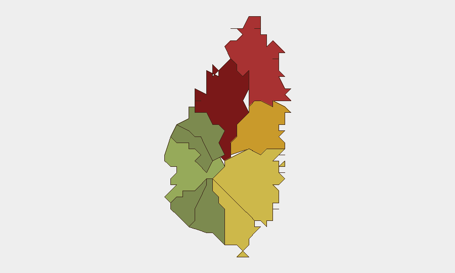
Saint Lucia presents a moderate security environment with a composite threat score of 6 (global rank #143), reflecting endemic urban crime concentrated in the capital and northern parishes rather than systemic instability or active conflict. No discrete security events have been recorded in the current monitoring window. The threat landscape remains characterized by localized criminal activity in Castries and surrounding districts, with risk declining sharply in rural southern and western areas.
Key Developments
No verifiable discrete security events have been identified in the last 24–48 hours. Web research for the requested window returned archived crime coverage, travel advisory pages, and non-time-stamped social media references without sufficient publication timestamps or corroborating sources to confirm current incidents. A social media post referencing drug and firearm charges against three individuals circulated without confirmed date or location metadata. Security teams should note that absence of reported events does not indicate absence of criminal activity; rather, it reflects reporting lag and limited real-time visibility in regional media and official channels.
Highest-Risk Areas
Castries (risk 95) and Gros Islet (risk 78) drive Saint Lucia's threat profile, accounting for the majority of recorded crime and violence. These urban and semi-urban parishes in the north are hubs of gang activity, drug trafficking, and street crime; Castries in particular concentrates government, port, and commercial infrastructure. Dennery (risk 72) and Vieux Fort (risk 68) represent secondary concern zones. Rural and southern districts (Canaries, Choiseul, Anse La Raye) register significantly lower composite risk, indicating that localized crime does not extend uniformly across the island.
How GeoBit Would Assist
Security teams managing personnel or assets in Castries, Gros Islet, or transit corridors should employ Intel Sweep and global event feeds to monitor emerging criminal incidents and gang activity with minimal reporting lag. AOI Monitoring & Early Warning with persistent watch on high-risk parishes (especially the port, commercial districts, and transportation nodes in Castries) can provide alert capability when incidents occur. Multi-language search, X/Twitter & Telegram OSINT, and sentiment analysis enable detection of emerging criminal narratives, gang tensions, or protest activity that may precede visible incidents. Routing & Network Analysis can support duty-of-care teams in identifying safer travel corridors and contingency routes around known crime hotspots.
7-Day Outlook
No imminent acute security escalation is indicated. Baseline criminal activity in northern parishes is expected to persist at endemic levels typical of Caribbean urban centers; seasonal patterns and local gang dynamics are the primary near-term drivers. Security teams should maintain standard vigilance protocols and monitor reporting channels for any spike in gang violence, drug-related incidents, or incidents affecting expatriate or corporate targets.
CAVEAT: This brief reflects the absence of time-verified event data in the current window. Real-time situational awareness depends on continuous monitoring via OSINT, local media, and official channels. GeoBit recommends activating persistent AOI watch on Castries and Gros Islet if duty-of-care exposure warrants real-time alerting.
Highest-Risk Areas — Ranked
| # | State / Region | Risk |
|---|---|---|
| 1 | Castries | 95 |
| 2 | Gros Islet | 78 |
| 3 | Dennery | 72 |
| 4 | Vieux Fort | 68 |
| 5 | Micoud | 65 |
| 6 | Soufrière | 42 |
| 7 | Laborie | 38 |
| 8 | Choiseul | 35 |
| 9 | Anse La Raye | 28 |
| 10 | Canaries | 12 |
Sources
- unitedpacstlucia.com
- unitedpacstlucia.com
- x.com
- saintluciadailypost.com
- unitedpacstlucia.com
- saintluciadailypost.com
- saintluciadailypost.com
- unitedpacstlucia.com
- stluciatimes.com
- caribbeantoday.com
- unitedpacstlucia.com
- stluciastar.com
- saintluciadailypost.com
- stluciatimes.com
- stluciatimes.com
- homeaffairs.govt.lc
- facebook.com
- globalnews.ca
Previous Daily Briefs
A new Saint Lucia brief is written every day — each with its own risk map and downloadable CSV. Here's the last week; use the calendar to go further back.
📅 Browse every day by calendar →
Highlighted days have a brief. Tap a day for that day's map & analysis, or “csv” for that day's dataset ($5).
Atlas — our AI intelligence desk — emails them this snapshot personally. Nothing else, no list.