Situation Summary
Samoa remains a low-threat environment with no security incidents, civil unrest, or infrastructure failures recorded in the last 24–48 hours (22–23 August 2026). The national composite threat score stands at 21 globally (rank #81), reflecting baseline crime patterns and stable governance. No escalation in the security posture is expected over the near term, and duty-of-care risk for corporate personnel and assets remains routine.
Key Developments
- No verifiable security incidents in Samoa (22–23 August 2026). Open-source monitoring, social media OSINT, and regional news feeds confirm absence of protests, serious crime spikes, infrastructure disruptions, or civil unrest within the last 24–48 hours.
- Samoa Police alert on online misinformation (17 August 2026, context). Police issued a public warning about AI-generated fake content and false accounts circulating on social media, but no physical incidents or unrest tied to these narratives have been reported.
- Magnitude 4.7 earthquake recorded, Samoa Islands region (19 August 2026, context). Seismic event at coordinates –15.917°, –172.731° produced no reported damage, casualties, or infrastructure disruption affecting current security or travel risk.
- Political-security case resolved (mid-August, background). A 49-year-old resident of Falelauniu was arrested and charged after posting threats to kill the Prime Minister on Facebook between 1–16 August; the arrest removed the acute incident from the active threat pipeline.
- Residential burglary pattern ongoing in Apia (through 19 August, localized). Petty crime reports from Siusega and Ululoloa in the Apia area continue a low-level trend; no organized escalation or gang activity noted.
- Samoa Airways aircraft recovery in progress (Fitiuta, Manu'a Islands). The DHC-6-300 runway excursion from 28 July remains under technical assessment and dismantling; recovery operations are expected to extend up to three months but pose no acute safety or security risk to mainland operations.
Highest-Risk Areas
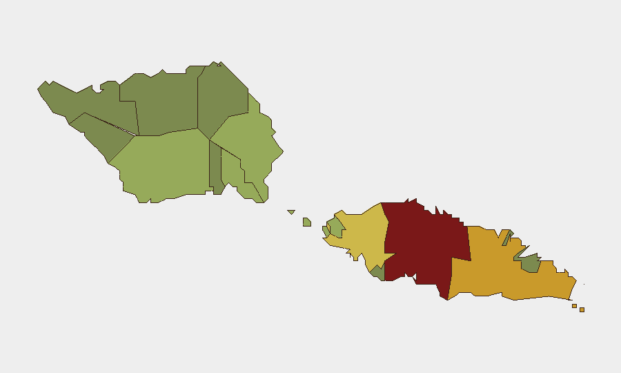
Tuamasaga District (risk score 85) drives the sub-national ranking, reflecting Apia's status as the capital and largest urban center, where petty crime, administrative friction, and urban congestion concentrate. Ātua (71) and Aʻana (62) follow as secondary urban and semi-urban zones where baseline theft and occasional interpersonal violence occur. Collectively, these three districts account for the majority of tracked crime and administrative incidents; rural and outer islands (Vaisigano, Vaʻa-o-Fonoti) present minimal risk. The ranking reflects crime density rather than organized violence, insurgency, or state failure.
How GeoBit Would Assist
Security teams with personnel or assets in Samoa would leverage AOI Monitoring & Early Warning to track Tuamasaga and Ātua districts for emerging crime clusters or civil unrest; Intel Sweep and X/Twitter OSINT to detect early signs of online agitation or misinformation campaigns affecting security posture; and Risk & Threat Assessment to model duty-of-care exposure for staff movements between Apia and outer islands. Maritime & Aviation tracking supports supply chain and personnel transit monitoring, especially given Samoa Airways' current operational constraints.
7-Day Outlook
No acute security triggers are anticipated over the next seven days. Routine crime monitoring should continue in central Apia, and teams should track Samoa Police public communications for any policy changes or incident escalations. The low-threat environment is expected to persist absent external regional developments in the South Pacific.
Highest-Risk Areas — Ranked
| # | State / Region | Risk |
|---|---|---|
| 1 | Tuamasaga | 85 |
| 2 | Ātua | 71 |
| 3 | Aʻana | 62 |
| 4 | Aiga-i-le-Tai | 55 |
| 5 | Faʻasaleleaga | 48 |
| 6 | Palauli | 42 |
| 7 | Satupaʻitea | 38 |
| 8 | Gagaʻemauga | 35 |
| 9 | Gagaʻifomauga | 32 |
| 10 | Vaisigano | 28 |
| 11 | Vaʻa-o-Fonoti | 23 |
Sources
Previous Daily Briefs
A new Samoa brief is written every day — each with its own risk map and downloadable CSV. Here's the last week; use the calendar to go further back.
- August 21, 2026
- August 19, 2026
- August 17, 2026
- August 15, 2026
- August 13, 2026
- August 11, 2026
- August 10, 2026
📅 Browse every day by calendar →
Highlighted days have a brief. Tap a day for that day's map & analysis, or “csv” for that day's dataset ($5).
Atlas — our AI intelligence desk — emails them this snapshot personally. Nothing else, no list.